Ialysós elevation
Ialysós (South Aegean, Dodecanese), Greece elevation is 16 meters and Ialysós elevation in feet is 52 ft above sea level [src 1]. Ialysós is a populated place (feature code) with elevation that is 135 meters (443 ft) smaller than average city elevation in Greece.
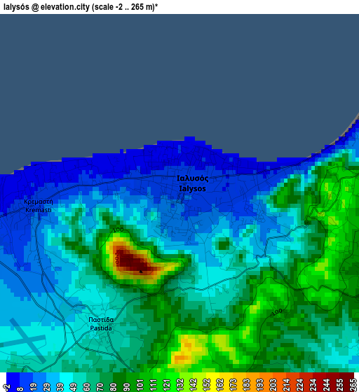
Below is the Elevation map of Ialysós, which displays elevation range with different colors. Scale of the first map is from -2 to 265 m (-7 to 869 ft) with average elevation of 59.2 meters (=194 ft) [note 1]
These maps also provides idea of topography and contour of this city, they are displayed at different zoom levels. More info about maps, scale and edge coordinates you can find below images.
| \ | Map #1 | Map #2 | Topo.Map |
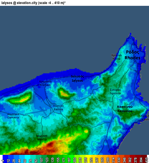
| Scale [m] | -2..265 m | -4..410 m | × |
| Scale [ft] | -7..869 ft | -13..1345 ft | × |
| Average | 59.2 m = 194 ft | 85.2 m = 280 ft | × |
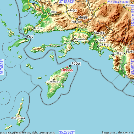
| Width | 7.86 km = 4.9 mi | 15.73 km = 9.8 mi | 251.7 km = 156.4 mi |
| Height | 7.86 km = 4.9 mi | 15.73 km = 9.8 mi | 251.7 km = 156.4 mi |
| ↑Max Latitude | 36.448877° | 36.484218° | 37.53693° |
| Latitude at center | 36.41352° | 36.41352° | 36.41352° |
| ↓Min Latitude | 36.378147° | 36.342757° | 35.27363° |
| ← Min Longitude | 28.111215° | 28.067269° | 26.74891° |
| Longitude center | 28.15516° | 28.15516° | 28.15516° |
| →Max Longitude | 28.199105° | 28.243051° | 29.56141° |
Nearby cities:
Cities around Ialysós sort by population:
• Ródos elevation 36 m
6.5 km,  67°
67°
• Kos 1 m
94 km,  304°
304°
• Faliraki 12 m
9.1 km,  154°
154°
• Afántou 28 m
13.4 km,  177°
177°
• Archángelos 163 m
22.4 km,  189°
189°
• Kremastí 15 m
3.2 km,  262°
262°
• Sými 4 m
36.3 km,  308°
308°
• Lárdos 18 m
37.6 km,  199°
199°
• Émponas 432 m
33.9 km,  232°
232°
• Mandráki 7 m
93.9 km,  283°
283°
• Megálo Chorió 34 m
72.6 km,  273°
273°
• Chálki 11 m
53.1 km,  246°
246°
Multilingual:
 En español:
Ialysós elevación 16 m.
 En France:
Ialysós élévation 16 m.


Sources and notes:
- [note 1] Map square and city borders are not equal. Map elevation data is calculated only from area inside that square.
- [src 1] Elevation data from geonames database provided with same terms of usage.
- [src 2] The elevation map of Ialysós is generated using elevation data from NASA's 3 arcsec (90m) resolution SRTM data.
- [src 3] Base (background) map © OpenStreetMap contributors tiles are generated by Geofabrik and OpenTopoMap.
Copyright & License:
This Ialysós Elevation Map is licensed under CC BY-SA. You may reuse any part from this page, if you give a proper credit by linking to this URL:
 More info on terms of use page.