Kos elevation
Kos (South Aegean, Dodecanese), Greece elevation is 1 meters and Kos elevation in feet is 3 ft above sea level [src 1]. Kos is a seat of a third-order administrative division (feature code) with elevation that is 150 meters (492 ft) smaller than average city elevation in Greece.
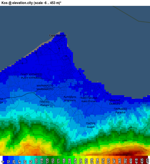
Below is the Elevation map of Kos, which displays elevation range with different colors. Scale of the first map is from -6 to 453 m (-20 to 1486 ft) with average elevation of 89.1 meters (=292 ft) [note 1]
These maps also provides idea of topography and contour of this city, they are displayed at different zoom levels. More info about maps, scale and edge coordinates you can find below images.
| \ | Map #1 | Map #2 | Topo.Map |
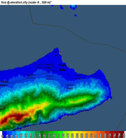
| Scale [m] | -6..453 m | -8..826 m | × |
| Scale [ft] | -20..1486 ft | -26..2710 ft | × |
| Average | 89.1 m = 292 ft | 173 m = 568 ft | × |
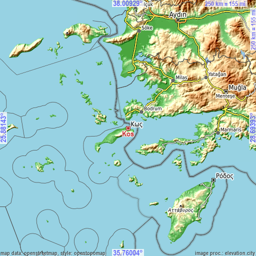
| Width | 7.82 km = 4.9 mi | 15.63 km = 9.7 mi | 250.1 km = 155.4 mi |
| Height | 7.82 km = 4.9 mi | 15.63 km = 9.7 mi | 250.1 km = 155.4 mi |
| ↑Max Latitude | 36.928088° | 36.963209° | 38.00929° |
| Latitude at center | 36.89295° | 36.89295° | 36.89295° |
| ↓Min Latitude | 36.857796° | 36.822626° | 35.76004° |
| ← Min Longitude | 27.243735° | 27.199789° | 25.88143° |
| Longitude center | 27.28768° | 27.28768° | 27.28768° |
| →Max Longitude | 27.331625° | 27.375571° | 28.69393° |
Nearby cities:
Cities around Kos sort by population:
• Kálymnos elevation 6 m
27.7 km,  283°
283°
• Agía Marína 59 m
48.4 km,  306°
306°
• Zipári 36 m
7.5 km,  256°
256°
• Kéfalos 109 m
33.5 km,  240°
240°
• Pylí 76 m
12.6 km, 244°
• Sými 4 m
57.8 km,  122°
122°
• Antimácheia 145 m
19.3 km, 241°
• Pánormos 13 m
32.3 km,  285°
285°
• Lakkí 5 m
47 km,  304°
304°
• Kardámaina 7 m
17.8 km,  226°
226°
• Mandráki 7 m
34.2 km,  203°
203°
• Megálo Chorió 34 m
49 km,  173°
173°


Sources and notes:
- [note 1] Map square and city borders are not equal. Map elevation data is calculated only from area inside that square.
- [src 1] Elevation data from geonames database provided with same terms of usage.
- [src 2] The elevation map of Kos is generated using elevation data from NASA's 3 arcsec (90m) resolution SRTM data.
- [src 3] Base (background) map © OpenStreetMap contributors tiles are generated by Geofabrik and OpenTopoMap.
Copyright & License:
This Kos Elevation Map is licensed under CC BY-SA. You may reuse any part from this page, if you give a proper credit by linking to this URL:
 More info on terms of use page.