Voúla elevation
Voúla (Attica, Nomarchía Anatolikís Attikís), Greece elevation is 54 meters and Voúla elevation in feet is 177 ft above sea level [src 1]. Voúla is a seat of a third-order administrative division (feature code) with elevation that is 97 meters (318 ft) smaller than average city elevation in Greece.
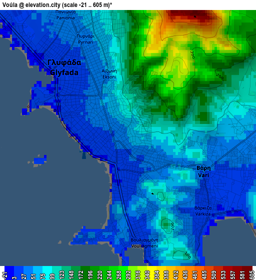
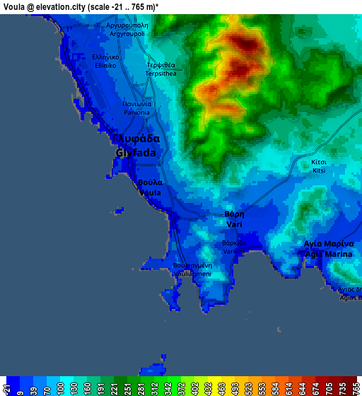
Below is the Elevation map of Voúla, which displays elevation range with different colors. Scale of the first map is from -21 to 605 m (-69 to 1985 ft) with average elevation of 104.6 meters (=343 ft) [note 1]
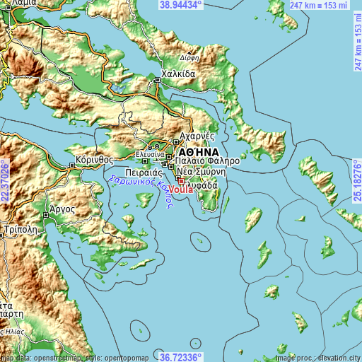
These maps also provides idea of topography and contour of this city, they are displayed at different zoom levels. More info about maps, scale and edge coordinates you can find below images.
| \ | Map #1 | Map #2 | Topo.Map |
| Scale [m] | -21..605 m | -21..765 m | × |
| Scale [ft] | -69..1985 ft | -69..2510 ft | × |
| Average | 104.6 m = 343 ft | 151.7 m = 498 ft | × |
| Width | 7.72 km = 4.8 mi | 15.43 km = 9.6 mi | 246.9 km = 153.4 mi |
| Height | 7.72 km = 4.8 mi | 15.43 km = 9.6 mi | 246.9 km = 153.4 mi |
| ↑Max Latitude | 37.876906° | 37.911585° | 38.94434° |
| Latitude at center | 37.84221° | 37.84221° | 37.84221° |
| ↓Min Latitude | 37.807498° | 37.77277° | 36.72336° |
| ← Min Longitude | 23.732565° | 23.688619° | 22.37026° |
| Longitude center | 23.77651° | 23.77651° | 23.77651° |
| →Max Longitude | 23.820455° | 23.864401° | 25.18276° |
Nearby cities:
Cities around Voúla sort by population:
• Glyfáda elevation 24 m
2.8 km,  324°
324°
• Ilioúpoli 308 m
10 km,  355°
355°
• Agios Dimitrios 73 m
10.8 km,  339°
339°
• Álimos 44 m
8.9 km,  328°
328°
• Argyroúpoli 67 m
7.4 km, 342°
• Koropí 130 m
10.5 km,  53°
53°
• Ellinikó 52 m
6 km, 331°
• Vári 30 m
2.5 km,  113°
113°
• Kítsi 98 m
5.7 km,  79°
79°
• Vouliagméni 6 m
3.1 km,  176°
176°
• Agía Marína 9 m
6.4 km, 112°
• Agios Dimítrios Kropiás 52 m
8.2 km,  119°
119°
Multilingual:
 En español:
Voúla elevación 54 m.
 En France:
Voúla élévation 54 m.


Sources and notes:
- [note 1] Map square and city borders are not equal. Map elevation data is calculated only from area inside that square.
- [src 1] Elevation data from geonames database provided with same terms of usage.
- [src 2] The elevation map of Voúla is generated using elevation data from NASA's 3 arcsec (90m) resolution SRTM data.
- [src 3] Base (background) map © OpenStreetMap contributors tiles are generated by Geofabrik and OpenTopoMap.
Copyright & License:
This Voúla Elevation Map is licensed under CC BY-SA. You may reuse any part from this page, if you give a proper credit by linking to this URL:
 More info on terms of use page.