Gérakas elevation
Gérakas (Attica, Nomarchía Anatolikís Attikís), Greece elevation is 250 meters and Gérakas elevation in feet is 820 ft above sea level [src 1]. Gérakas is a seat of a third-order administrative division (feature code) with elevation that is 99 meters (325 ft) bigger than average city elevation in Greece.
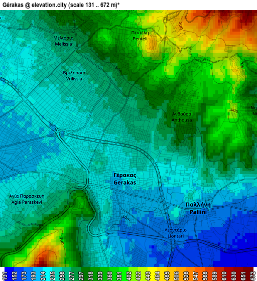
Below is the Elevation map of Gérakas, which displays elevation range with different colors. Scale of the first map is from 131 to 672 m (430 to 2205 ft) with average elevation of 281.8 meters (=925 ft) [note 1]
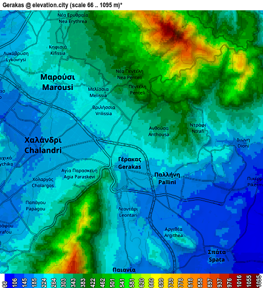
These maps also provides idea of topography and contour of this city, they are displayed at different zoom levels. More info about maps, scale and edge coordinates you can find below images.

| \ | Map #1 | Map #2 | Topo.Map |
| Scale [m] | 131..672 m | 66..1095 m | × |
| Scale [ft] | 430..2205 ft | 217..3593 ft | × |
| Average | 281.8 m = 925 ft | 303.7 m = 996 ft | × |
| Width | 7.7 km = 4.8 mi | 15.4 km = 9.6 mi | 246.3 km = 153 mi |
| Height | 7.7 km = 4.8 mi | 15.4 km = 9.6 mi | 246.3 km = 153 mi |
| ↑Max Latitude | 38.05738° | 38.091975° | 39.12217° |
| Latitude at center | 38.02277° | 38.02277° | 38.02277° |
| ↓Min Latitude | 37.988143° | 37.9535° | 36.90663° |
| ← Min Longitude | 23.813655° | 23.769709° | 22.45135° |
| Longitude center | 23.8576° | 23.8576° | 23.8576° |
| →Max Longitude | 23.901545° | 23.945491° | 25.26385° |
Nearby cities:
Cities around Gérakas sort by population:
• Khalándrion elevation 194 m
5 km,  271°
271°
• Agía Paraskeví 216 m
2.2 km,  252°
252°
• Cholargós 219 m
5.6 km,  243°
243°
• Vrilissia 232 m
2.7 km,  296°
296°
• Melíssia 273 m
3.7 km,  324°
324°
• Pallíni 199 m
3 km,  131°
131°
• Néa Pentéli 432 m
4.2 km,  1°
1°
• Leondárion 207 m
4 km,  183°
183°
• Pentéli 450 m
3.1 km,  14°
14°
• Dhráfi 268 m
4.4 km,  88°
88°
• Anthoúsa 316 m
1.7 km,  79°
79°
• Argithéa 224 m
5.8 km,  155°
155°
Multilingual:
 En español:
Gérakas elevación 250 m.
 En France:
Gérakas élévation 250 m.


Sources and notes:
- [note 1] Map square and city borders are not equal. Map elevation data is calculated only from area inside that square.
- [src 1] Elevation data from geonames database provided with same terms of usage.
- [src 2] The elevation map of Gérakas is generated using elevation data from NASA's 3 arcsec (90m) resolution SRTM data.
- [src 3] Base (background) map © OpenStreetMap contributors tiles are generated by Geofabrik and OpenTopoMap.
Copyright & License:
This Gérakas Elevation Map is licensed under CC BY-SA. You may reuse any part from this page, if you give a proper credit by linking to this URL:
 More info on terms of use page.