Malabo elevation
Malabo (Bioko Norte), Equatorial Guinea elevation is 106 meters and Malabo elevation in feet is 348 ft above sea level [src 1]. Malabo is a capital of a political entity (feature code) with elevation that is 240 meters (787 ft) smaller than average city elevation in Equatorial Guinea.
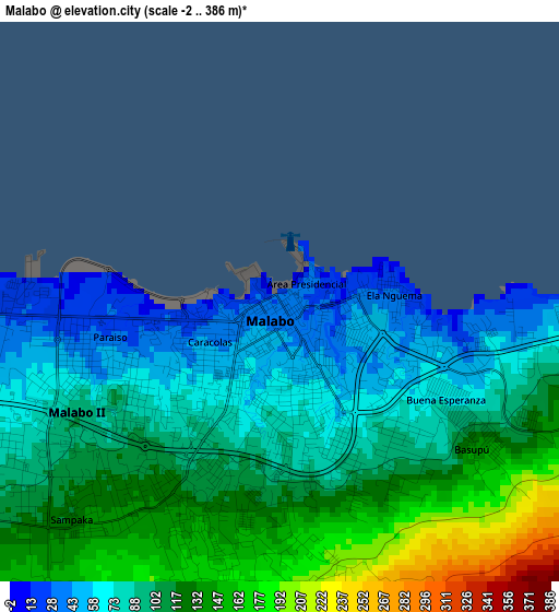
Below is the Elevation map of Malabo, which displays elevation range with different colors. Scale of the first map is from -2 to 386 m (-7 to 1266 ft) with average elevation of 102.5 meters (=336 ft) [note 1]
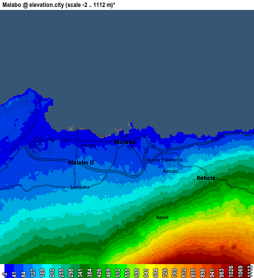
These maps also provides idea of topography and contour of this city, they are displayed at different zoom levels. More info about maps, scale and edge coordinates you can find below images.
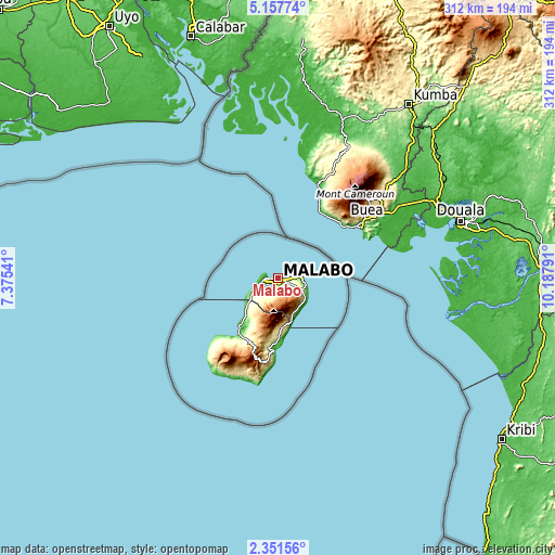
| \ | Map #1 | Map #2 | Topo.Map |
| Scale [m] | -2..386 m | -2..1112 m | × |
| Scale [ft] | -7..1266 ft | -7..3648 ft | × |
| Average | 102.5 m = 336 ft | 290.9 m = 954 ft | × |
| Width | 9.75 km = 6.1 mi | 19.5 km = 12.1 mi | 312 km = 193.9 mi |
| Height | 9.75 km = 6.1 mi | 19.5 km = 12.1 mi | 312 km = 193.9 mi |
| ↑Max Latitude | 3.79963° | 3.843477° | 5.15774° |
| Latitude at center | 3.75578° | 3.75578° | 3.75578° |
| ↓Min Latitude | 3.711928° | 3.668074° | 2.35156° |
| ← Min Longitude | 8.737715° | 8.693769° | 7.37541° |
| Longitude center | 8.78166° | 8.78166° | 8.78166° |
| →Max Longitude | 8.825605° | 8.869551° | 10.18791° |
Nearby cities:
Cities around Malabo sort by population:
• Bata elevation 13 m
237.1 km,  152°
152°
• Añisoc 456 m
304.7 km,  133°
133°
• Luba 72 m
41.7 km,  217°
217°
• Mikomeseng 542 m
271.7 km, 131°
• Rebola 394 m
7.2 km, 127°
• Mbini 13 m
258.7 km,  159°
159°
• Ayene 443 m
299.2 km, 134°
• Machinda 174 m
245.5 km, 148°
• Santiago de Baney 284 m
15.4 km,  114°
114°
• Ncue 399 m
269.4 km,  135°
135°
• Bitica 28 m
275.4 km, 160°
• Río Campo 28 m
195.4 km, 143°
Multilingual:
 En español:
Ciudad de Malabo, Santa Isabel, Malabo elevación 106 m.
 En France:
Malabo élévation 106 m.


Sources and notes:
- [note 1] Map square and city borders are not equal. Map elevation data is calculated only from area inside that square.
- [src 1] Elevation data from geonames database provided with same terms of usage.
- [src 2] The elevation map of Malabo is generated using elevation data from NASA's 3 arcsec (90m) resolution SRTM data.
- [src 3] Base (background) map © OpenStreetMap contributors tiles are generated by Geofabrik and OpenTopoMap.
Copyright & License:
This Malabo Elevation Map is licensed under CC BY-SA. You may reuse any part from this page, if you give a proper credit by linking to this URL:
 More info on terms of use page.