Youkounkoun elevation
Youkounkoun (Boke, Koundara Prefecture), Guinea elevation is 76 meters and Youkounkoun elevation in feet is 249 ft above sea level [src 1]. Youkounkoun is a populated place (feature code) with elevation that is 357 meters (1171 ft) smaller than average city elevation in Guinea.
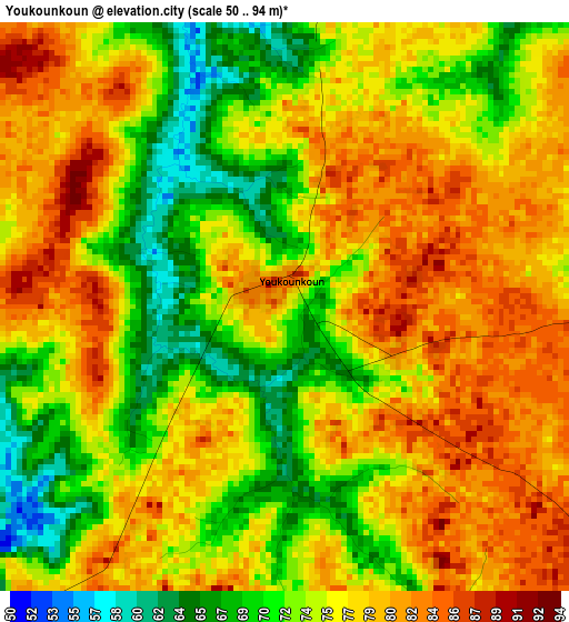
Below is the Elevation map of Youkounkoun, which displays elevation range with different colors. Scale of the first map is from 50 to 94 m (164 to 308 ft) with average elevation of 75.9 meters (=249 ft) [note 1]
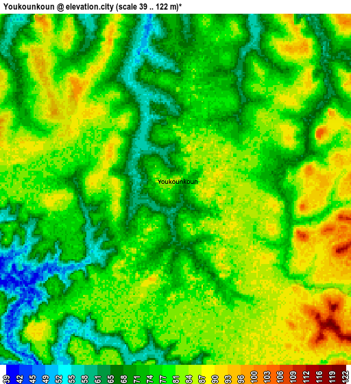
These maps also provides idea of topography and contour of this city, they are displayed at different zoom levels. More info about maps, scale and edge coordinates you can find below images.
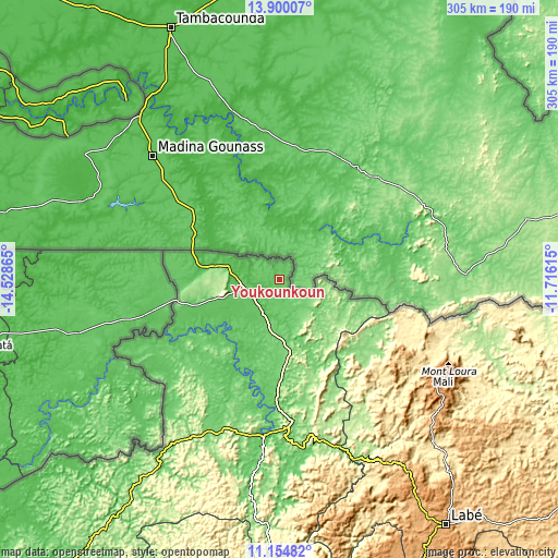
| \ | Map #1 | Map #2 | Topo.Map |
| Scale [m] | 50..94 m | 39..122 m | × |
| Scale [ft] | 164..308 ft | 128..400 ft | × |
| Average | 75.9 m = 249 ft | 77.1 m = 253 ft | × |
| Width | 9.54 km = 5.9 mi | 19.08 km = 11.9 mi | 305.2 km = 189.6 mi |
| Height | 9.54 km = 5.9 mi | 19.08 km = 11.9 mi | 305.3 km = 189.7 mi |
| ↑Max Latitude | 12.573995° | 12.616883° | 13.90007° |
| Latitude at center | 12.5311° | 12.5311° | 12.5311° |
| ↓Min Latitude | 12.488198° | 12.445289° | 11.15482° |
| ← Min Longitude | -13.166345° | -13.210291° | -14.52865° |
| Longitude center | -13.1224° | -13.1224° | -13.1224° |
| →Max Longitude | -13.078455° | -13.034509° | -11.71615° |
Nearby cities:
Cities around Youkounkoun sort by population:
• Labé elevation 1026 m
162.8 km,  145°
145°
• Télimélé 610 m
181.6 km,  176°
176°
• Tougué 805 m
199.3 km,  127°
127°
• Pita 973 m
181.8 km, 154°
• Boké 49 m
218.6 km,  215°
215°
• Koundara 77 m
20 km,  254°
254°
• Koubia 750 m
169.9 km, 128°
• Kimbo 262 m
241.5 km,  191°
191°
• Gaoual 79 m
87.3 km, 185°
• Dalaba 1240 m
225.4 km,  155°
155°
• Mali 1440 m
102.7 km,  119°
119°
• Lélouma 955 m
132.1 km, 158°
Multilingual:
 En español:
Youkounkoun elevación 76 m.
 En France:
Youkounkoun élévation 76 m.
 Auf Deutsch:
Youkounkoun höhe über dem Meeresspiegel ist 76 m.

Sources and notes:
- [note 1] Map square and city borders are not equal. Map elevation data is calculated only from area inside that square.
- [src 1] Elevation data from geonames database provided with same terms of usage.
- [src 2] The elevation map of Youkounkoun is generated using elevation data from NASA's 3 arcsec (90m) resolution SRTM data.
- [src 3] Base (background) map © OpenStreetMap contributors tiles are generated by Geofabrik and OpenTopoMap.
Copyright & License:
This Youkounkoun Elevation Map is licensed under CC BY-SA. You may reuse any part from this page, if you give a proper credit by linking to this URL:
 More info on terms of use page.