Bolnisi elevation
Bolnisi (Kvemo Kartli, Bolnisis Munitsip’alit’et’i), Georgia elevation is 524 meters and Bolnisi elevation in feet is 1719 ft above sea level [src 1]. Bolnisi is a seat of a second-order administrative division (feature code) with elevation that is 16 meters (52 ft) smaller than average city elevation in Georgia.
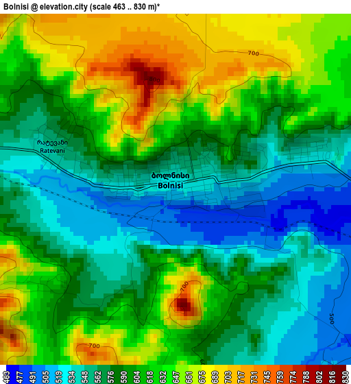
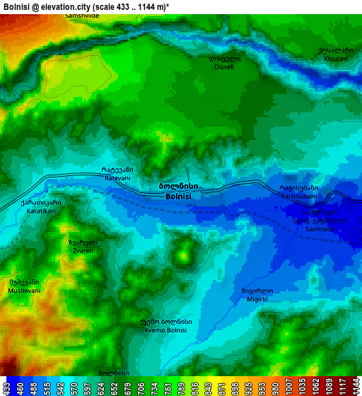
Below is the Elevation map of Bolnisi, which displays elevation range with different colors. Scale of the first map is from 463 to 830 m (1519 to 2723 ft) with average elevation of 599.4 meters (=1967 ft) [note 1]
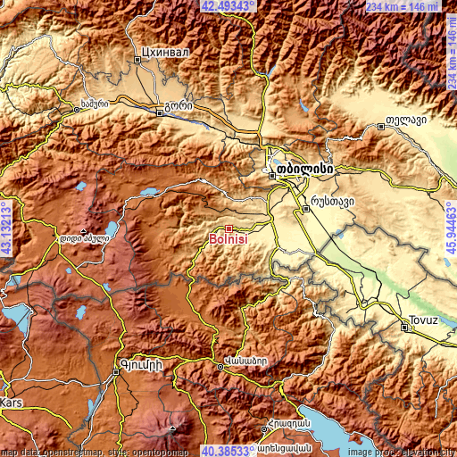
These maps also provides idea of topography and contour of this city, they are displayed at different zoom levels. More info about maps, scale and edge coordinates you can find below images.
| \ | Map #1 | Map #2 | Topo.Map |
| Scale [m] | 463..830 m | 433..1144 m | × |
| Scale [ft] | 1519..2723 ft | 1421..3753 ft | × |
| Average | 599.4 m = 1967 ft | 646.5 m = 2121 ft | × |
| Width | 7.33 km = 4.6 mi | 14.65 km = 9.1 mi | 234.4 km = 145.6 mi |
| Height | 7.33 km = 4.6 mi | 14.65 km = 9.1 mi | 234.4 km = 145.6 mi |
| ↑Max Latitude | 41.480871° | 41.513786° | 42.49343° |
| Latitude at center | 41.44794° | 41.44794° | 41.44794° |
| ↓Min Latitude | 41.414992° | 41.382027° | 40.38533° |
| ← Min Longitude | 44.494435° | 44.450489° | 43.13213° |
| Longitude center | 44.53838° | 44.53838° | 44.53838° |
| →Max Longitude | 44.582325° | 44.626271° | 45.94463° |
Nearby cities:
Cities around Bolnisi sort by population:
• Tbilisi elevation 491 m
36.8 km,  41°
41°
• Rust’avi 338 m
39.5 km,  73°
73°
• Marneuli 408 m
22.8 km,  82°
82°
• Gardabani 306 m
46.2 km,  88°
88°
• Naghvarevi 493 m
21.4 km,  119°
119°
• Manglisi 1195 m
30.5 km,  335°
335°
• Tsqnet’i 947 m
30.5 km,  25°
25°
• T’et’ri Tsqaro 1174 m
12.5 km,  329°
329°
• Dmanisi 1168 m
18.1 km,  298°
298°
• Dzegvi 503 m
44.5 km,  6°
6°
• Zahesi 487 m
45.5 km,  23°
23°
• Tsalka 1482 m
40.8 km,  293°
293°
Multilingual:
 En español:
Bolnisi elevación 524 m.
 En France:
Bolnissi élévation 524 m.
 Auf Deutsch:
Bolnissi, Katharinenfeld höhe über dem Meeresspiegel ist 524 m.

Sources and notes:
- [note 1] Map square and city borders are not equal. Map elevation data is calculated only from area inside that square.
- [src 1] Elevation data from geonames database provided with same terms of usage.
- [src 2] The elevation map of Bolnisi is generated using elevation data from NASA's 3 arcsec (90m) resolution SRTM data.
- [src 3] Base (background) map © OpenStreetMap contributors tiles are generated by Geofabrik and OpenTopoMap.
Copyright & License:
This Bolnisi Elevation Map is licensed under CC BY-SA. You may reuse any part from this page, if you give a proper credit by linking to this URL:
 More info on terms of use page.