Tsqnet’i elevation
Tsqnet’i, Georgia elevation is 947 meters and Tsqnet’i elevation in feet is 3107 ft above sea level [src 1]. Tsqnet’i is a populated place (feature code) with elevation that is 407 meters (1335 ft) bigger than average city elevation in Georgia.
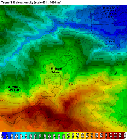
Below is the Elevation map of Tsqnet’i, which displays elevation range with different colors. Scale of the first map is from 461 to 1494 m (1512 to 4902 ft) with average elevation of 904.7 meters (=2968 ft) [note 1]
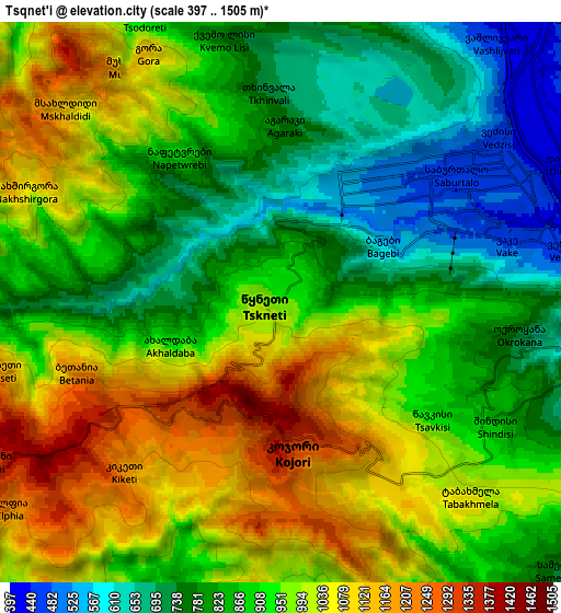
These maps also provides idea of topography and contour of this city, they are displayed at different zoom levels. More info about maps, scale and edge coordinates you can find below images.
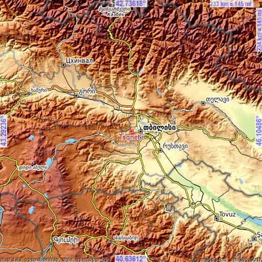
| \ | Map #1 | Map #2 | Topo.Map |
| Scale [m] | 461..1494 m | 397..1505 m | × |
| Scale [ft] | 1512..4902 ft | 1302..4938 ft | × |
| Average | 904.7 m = 2968 ft | 913.6 m = 2997 ft | × |
| Width | 7.3 km = 4.5 mi | 14.59 km = 9.1 mi | 233.5 km = 145.1 mi |
| Height | 7.3 km = 4.5 mi | 14.59 km = 9.1 mi | 233.5 km = 145.1 mi |
| ↑Max Latitude | 41.727526° | 41.760314° | 42.73618° |
| Latitude at center | 41.69472° | 41.69472° | 41.69472° |
| ↓Min Latitude | 41.661898° | 41.629059° | 40.63612° |
| ← Min Longitude | 44.654665° | 44.610719° | 43.29236° |
| Longitude center | 44.69861° | 44.69861° | 44.69861° |
| →Max Longitude | 44.742555° | 44.786501° | 46.10486° |
Nearby cities:
Cities around Tsqnet’i sort by population:
• Tbilisi elevation 491 m
11.2 km,  90°
90°
• Rust’avi 338 m
29.3 km,  123°
123°
• Marneuli 408 m
26 km,  159°
159°
• Kaspi 549 m
34.2 km,  318°
318°
• Bolnisi 524 m
30.5 km,  205°
205°
• Mtskheta 476 m
16.8 km,  5°
5°
• Manglisi 1195 m
26.1 km,  270°
270°
• T’et’ri Tsqaro 1174 m
25.8 km,  229°
229°
• Didi Lilo 789 m
22.6 km,  78°
78°
• Dmanisi 1168 m
34.8 km,  237°
237°
• Dzegvi 503 m
18.6 km,  334°
334°
• Zahesi 487 m
15.1 km,  17°
17°
Multilingual:
 En español:
Tsqnet’i elevación 947 m.
 En France:
Tsqnet’i élévation 947 m.
 Auf Deutsch:
Tsqnet’i höhe über dem Meeresspiegel ist 947 m.

Sources and notes:
- [note 1] Map square and city borders are not equal. Map elevation data is calculated only from area inside that square.
- [src 1] Elevation data from geonames database provided with same terms of usage.
- [src 2] The elevation map of Tsqnet’i is generated using elevation data from NASA's 3 arcsec (90m) resolution SRTM data.
- [src 3] Base (background) map © OpenStreetMap contributors tiles are generated by Geofabrik and OpenTopoMap.
Copyright & License:
This Tsqnet’i Elevation Map is licensed under CC BY-SA. You may reuse any part from this page, if you give a proper credit by linking to this URL:
 More info on terms of use page.