Lent’ekhi elevation
Lent’ekhi (Racha-Lechkhumi and Kvemo Svaneti), Georgia elevation is 738 meters and Lent’ekhi elevation in feet is 2421 ft above sea level [src 1]. Lent’ekhi is a populated place (feature code) with elevation that is 198 meters (650 ft) bigger than average city elevation in Georgia.
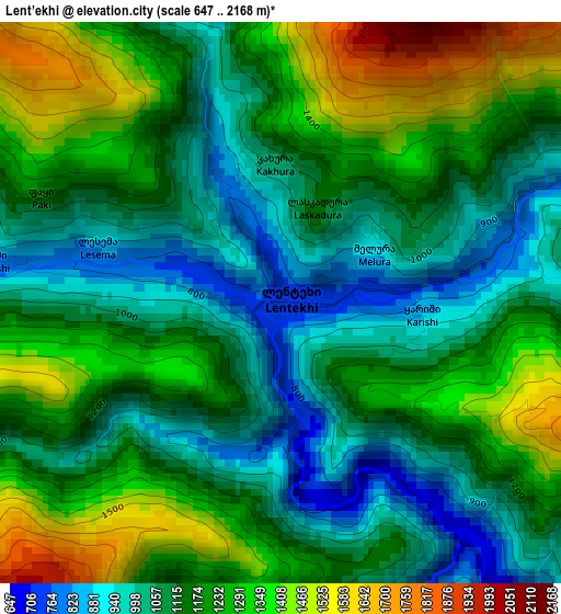
Below is the Elevation map of Lent’ekhi, which displays elevation range with different colors. Scale of the first map is from 647 to 2168 m (2123 to 7113 ft) with average elevation of 1170.4 meters (=3840 ft) [note 1]
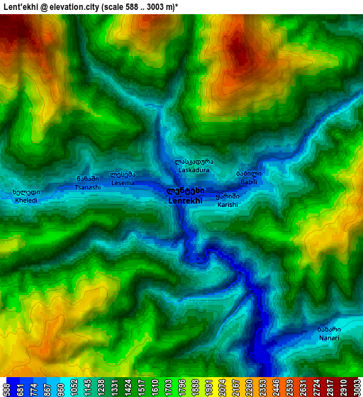
These maps also provides idea of topography and contour of this city, they are displayed at different zoom levels. More info about maps, scale and edge coordinates you can find below images.
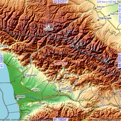
| \ | Map #1 | Map #2 | Topo.Map |
| Scale [m] | 647..2168 m | 588..3003 m | × |
| Scale [ft] | 2123..7113 ft | 1929..9852 ft | × |
| Average | 1170.4 m = 3840 ft | 1495.7 m = 4907 ft | × |
| Width | 7.17 km = 4.5 mi | 14.34 km = 8.9 mi | 229.5 km = 142.6 mi |
| Height | 7.17 km = 4.5 mi | 14.34 km = 8.9 mi | 229.5 km = 142.6 mi |
| ↑Max Latitude | 42.821171° | 42.853396° | 43.81231° |
| Latitude at center | 42.78893° | 42.78893° | 42.78893° |
| ↓Min Latitude | 42.756672° | 42.724397° | 41.74834° |
| ← Min Longitude | 42.678315° | 42.634369° | 41.31601° |
| Longitude center | 42.72226° | 42.72226° | 42.72226° |
| →Max Longitude | 42.766205° | 42.810151° | 44.12851° |
Nearby cities:
Cities around Lent’ekhi sort by population:
• Kutaisi elevation 153 m
58 km,  182°
182°
• Tsqaltubo 142 m
50.8 km,  191°
191°
• Tqibuli 565 m
53.7 km,  155°
155°
• Khoni 118 m
57.4 km,  205°
205°
• Tsalenjikha 179 m
57.2 km,  249°
249°
• Mart’vili 194 m
50.2 km, 213°
• Jvari 335 m
55.3 km,  261°
261°
• Kveda Chkhorots’q’u 125 m
61.6 km,  236°
236°
• Mest’ia 1412 m
28.6 km,  0°
0°
• Oni 838 m
63.3 km,  111°
111°
• Ambrolauri 609 m
46.7 km,  129°
129°
• Gori 705 m
47.3 km, 129°
Multilingual:
 En español:
Lent’ekhi elevación 738 m.
 En France:
Lent’ekhi élévation 738 m.
 Auf Deutsch:
Lent’ekhi höhe über dem Meeresspiegel ist 738 m.

Sources and notes:
- [note 1] Map square and city borders are not equal. Map elevation data is calculated only from area inside that square.
- [src 1] Elevation data from geonames database provided with same terms of usage.
- [src 2] The elevation map of Lent’ekhi is generated using elevation data from NASA's 3 arcsec (90m) resolution SRTM data.
- [src 3] Base (background) map © OpenStreetMap contributors tiles are generated by Geofabrik and OpenTopoMap.
Copyright & License:
This Lent’ekhi Elevation Map is licensed under CC BY-SA. You may reuse any part from this page, if you give a proper credit by linking to this URL:
 More info on terms of use page.