Culloden elevation
Culloden (Scotland, Highland), United Kingdom elevation is 38 meters and Culloden elevation in feet is 125 ft above sea level [src 1]. Culloden is a populated place (feature code) with elevation that is 34 meters (112 ft) smaller than average city elevation in United Kingdom.
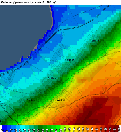
Below is the Elevation map of Culloden, which displays elevation range with different colors. Scale of the first map is from -2 to 188 m (-7 to 617 ft) with average elevation of 75.8 meters (=249 ft) [note 1]
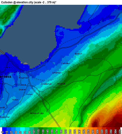
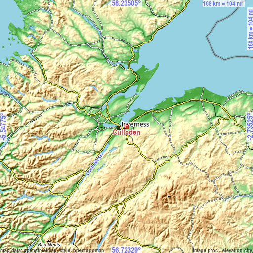
These maps also provides idea of topography and contour of this city, they are displayed at different zoom levels. More info about maps, scale and edge coordinates you can find below images.
| \ | Map #1 | Map #2 | Topo.Map |
| Scale [m] | -2..188 m | -2..379 m | × |
| Scale [ft] | -7..617 ft | -7..1243 ft | × |
| Average | 75.8 m = 249 ft | 103.9 m = 341 ft | × |
| Width | 5.25 km = 3.3 mi | 10.51 km = 6.5 mi | 168.1 km = 104.5 mi |
| Height | 5.25 km = 3.3 mi | 10.51 km = 6.5 mi | 168.1 km = 104.5 mi |
| ↑Max Latitude | 57.510603° | 57.5342° | 58.23505° |
| Latitude at center | 57.48699° | 57.48699° | 57.48699° |
| ↓Min Latitude | 57.463362° | 57.439719° | 56.72329° |
| ← Min Longitude | -4.185445° | -4.229391° | -5.54775° |
| Longitude center | -4.1415° | -4.1415° | -4.1415° |
| →Max Longitude | -4.097555° | -4.053609° | -2.73525° |
Nearby cities:
Cities around Culloden sort by population:
• Inverness elevation 15 m
5 km,  259°
259°
• Nairn 20 m
18.8 km,  56°
56°
• Westhill 92 m
1.6 km,  196°
196°
• Muir of Ord 35 m
19.3 km,  280°
280°
• Smithton 48 m
1 km,  215°
215°
• Milton of Leys 150 m
4.5 km,  207°
207°
• Conon Bridge 8 m
19.7 km,  296°
296°
• Balloch 69 m
1.6 km,  69°
69°
• Fortrose 25 m
10.5 km,  2°
2°
• Beauly 7 m
19.1 km,  268°
268°
• Ardersier 5 m
10.8 km,  34°
34°
• Highland 3 m
5.2 km, 268°
Multilingual:
 En español:
Culloden elevación 38 m.
 En France:
Culloden élévation 38 m.


Sources and notes:
- [note 1] Map square and city borders are not equal. Map elevation data is calculated only from area inside that square.
- [src 1] Elevation data from geonames database provided with same terms of usage.
- [src 2] The elevation map of Culloden is generated using elevation data from NASA's 3 arcsec (90m) resolution SRTM data.
- [src 3] Base (background) map © OpenStreetMap contributors tiles are generated by Geofabrik and OpenTopoMap.
Copyright & License:
This Culloden Elevation Map is licensed under CC BY-SA. You may reuse any part from this page, if you give a proper credit by linking to this URL:
 More info on terms of use page.