Hockley Heath elevation
Hockley Heath (England, Solihull), United Kingdom elevation is 143 meters and Hockley Heath elevation in feet is 469 ft above sea level [src 1]. Hockley Heath is a populated place (feature code) with elevation that is 71 meters (233 ft) bigger than average city elevation in United Kingdom.
Below is the Elevation map of Hockley Heath, which displays elevation range with different colors. Scale of the first map is from 103 to 158 m (338 to 518 ft) with average elevation of 132.9 meters (=436 ft) [note 1]
These maps also provides idea of topography and contour of this city, they are displayed at different zoom levels. More info about maps, scale and edge coordinates you can find below images.
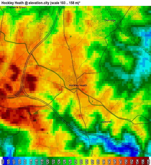
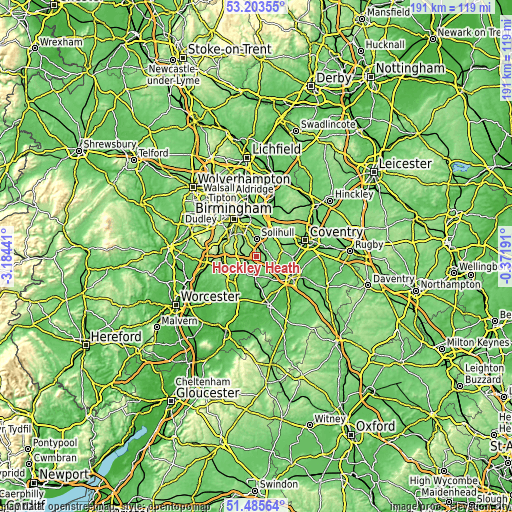
| \ | Map #1 | Topo.Map |
| Scale [m] | 103..158 m | × |
| Scale [ft] | 338..518 ft | × |
| Average | 132.9 m = 436 ft | × |
| Width | 5.97 km = 3.7 mi | 191 km = 118.7 mi |
| Height | 5.97 km = 3.7 mi | 191 km = 118.7 mi |
| ↑Max Latitude | 52.379773° | 53.20355° |
| Latitude at center | 52.35294° | 52.35294° |
| ↓Min Latitude | 52.32609° | 51.48564° |
| ← Min Longitude | -1.822105° | -3.18441° |
| Longitude center | -1.77816° | -1.77816° |
| →Max Longitude | -1.734215° | -0.37191° |
Nearby cities:
Cities around Hockley Heath sort by population:
• Solihull elevation 132 m
6.8 km,  358°
358°
• Shirley 145 m
7 km,  336°
336°
• Knowle 124 m
4.5 km,  42°
42°
• Dorridge 125 m
2.8 km, 37°
• Balsall Common 124 m
9.7 km,  63°
63°
• Dickens Heath 150 m
5.5 km,  311°
311°
• Henley in Arden 74 m
7 km,  179°
179°
• Wroxall 131 m
7.6 km,  102°
102°
• Hampton in Arden 123 m
9.5 km,  32°
32°
• Barston 118 m
7.7 km,  47°
47°
• Tidbury Green 158 m
6.1 km,  300°
300°
• Cheswick Green 136 m
3.9 km,  321°
321°
Multilingual:
 En español:
Hockley Heath elevación 143 m.
 En France:
Hockley Heath élévation 143 m.
 Auf Deutsch:
Hockley Heath höhe über dem Meeresspiegel ist 143 m.

Sources and notes:
- [note 1] Map square and city borders are not equal. Map elevation data is calculated only from area inside that square.
- [src 1] Elevation data from geonames database provided with same terms of usage.
- [src 2] The elevation map of Hockley Heath is generated using elevation data from NASA's 3 arcsec (90m) resolution SRTM data.
- [src 3] Base (background) map © OpenStreetMap contributors tiles are generated by Geofabrik and OpenTopoMap.
Copyright & License:
This Hockley Heath Elevation Map is licensed under CC BY-SA. You may reuse any part from this page, if you give a proper credit by linking to this URL:
 More info on terms of use page.