Neston elevation
Neston (England, Wiltshire), United Kingdom elevation is 119 meters and Neston elevation in feet is 390 ft above sea level [src 1]. Neston is a populated place (feature code) with elevation that is 47 meters (154 ft) bigger than average city elevation in United Kingdom.
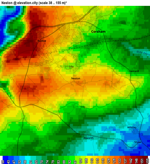
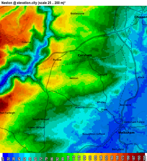
Below is the Elevation map of Neston, which displays elevation range with different colors. Scale of the first map is from 38 to 155 m (125 to 509 ft) with average elevation of 95.6 meters (=314 ft) [note 1]
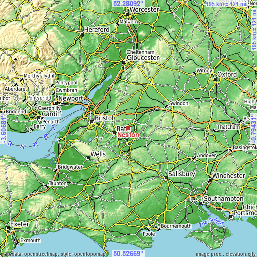
These maps also provides idea of topography and contour of this city, they are displayed at different zoom levels. More info about maps, scale and edge coordinates you can find below images.
| \ | Map #1 | Map #2 | Topo.Map |
| Scale [m] | 38..155 m | 25..200 m | × |
| Scale [ft] | 125..509 ft | 82..656 ft | × |
| Average | 95.6 m = 314 ft | 86 m = 282 ft | × |
| Width | 6.1 km = 3.8 mi | 12.19 km = 7.6 mi | 195.1 km = 121.2 mi |
| Height | 6.1 km = 3.8 mi | 12.19 km = 7.6 mi | 195 km = 121.2 mi |
| ↑Max Latitude | 51.439621° | 51.467006° | 52.28092° |
| Latitude at center | 51.41222° | 51.41222° | 51.41222° |
| ↓Min Latitude | 51.384803° | 51.357369° | 50.52669° |
| ← Min Longitude | -2.244505° | -2.288451° | -3.60681° |
| Longitude center | -2.20056° | -2.20056° | -2.20056° |
| →Max Longitude | -2.156615° | -2.112669° | -0.79431° |
Nearby cities:
Cities around Neston sort by population:
• Chippenham elevation 61 m
7.5 km,  44°
44°
• Melksham 41 m
6.1 km,  136°
136°
• Corsham 96 m
2.7 km,  24°
24°
• Colerne 164 m
5.2 km,  303°
303°
• Whitley 53 m
3.1 km,  126°
126°
• Atworth 67 m
2.3 km,  166°
166°
• Holt 41 m
6.3 km,  177°
177°
• Biddestone 120 m
5.4 km,  1°
1°
• Lacock 48 m
5.5 km,  86°
86°
• Bathford 64 m
7.1 km,  259°
259°
• Monkton Farleigh 167 m
6.2 km,  244°
244°
• Box 90 m
3.1 km,  275°
275°
Multilingual:
 En español:
Neston elevación 119 m.
 En France:
Neston élévation 119 m.


Sources and notes:
- [note 1] Map square and city borders are not equal. Map elevation data is calculated only from area inside that square.
- [src 1] Elevation data from geonames database provided with same terms of usage.
- [src 2] The elevation map of Neston is generated using elevation data from NASA's 3 arcsec (90m) resolution SRTM data.
- [src 3] Base (background) map © OpenStreetMap contributors tiles are generated by Geofabrik and OpenTopoMap.
Copyright & License:
This Neston Elevation Map is licensed under CC BY-SA. You may reuse any part from this page, if you give a proper credit by linking to this URL:
 More info on terms of use page.