Bangor elevation
Bangor (Wales, Gwynedd), United Kingdom elevation is 23 meters and Bangor elevation in feet is 75 ft above sea level [src 1]. Bangor is a populated place (feature code) with elevation that is 49 meters (161 ft) smaller than average city elevation in United Kingdom.
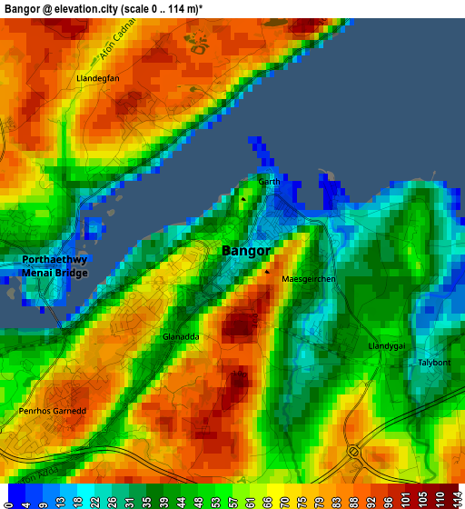
Below is the Elevation map of Bangor, which displays elevation range with different colors. Scale of the first map is from 0 to 114 m (0 to 374 ft) with average elevation of 59.4 meters (=195 ft) [note 1]
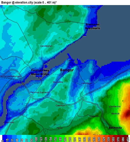
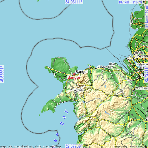
These maps also provides idea of topography and contour of this city, they are displayed at different zoom levels. More info about maps, scale and edge coordinates you can find below images.
| \ | Map #1 | Map #2 | Topo.Map |
| Scale [m] | 0..114 m | 0..401 m | × |
| Scale [ft] | 0..374 ft | 0..1316 ft | × |
| Average | 59.4 m = 195 ft | 87.6 m = 287 ft | × |
| Width | 5.85 km = 3.6 mi | 11.7 km = 7.3 mi | 187.2 km = 116.3 mi |
| Height | 5.85 km = 3.6 mi | 11.7 km = 7.3 mi | 187.2 km = 116.3 mi |
| ↑Max Latitude | 53.253819° | 53.280102° | 54.06111° |
| Latitude at center | 53.22752° | 53.22752° | 53.22752° |
| ↓Min Latitude | 53.201205° | 53.174873° | 52.37739° |
| ← Min Longitude | -4.173305° | -4.217251° | -5.53561° |
| Longitude center | -4.12936° | -4.12936° | -4.12936° |
| →Max Longitude | -4.085415° | -4.041469° | -2.72311° |
Nearby cities:
Cities around Bangor sort by population:
• Menai Bridge elevation 34 m
2.7 km,  270°
270°
• Bethesda 176 m
7 km,  137°
137°
• Llanfairfechan 22 m
10.9 km,  71°
71°
• Llanfairpwllgwyngyll 42 m
5 km,  262°
262°
• Y Felinheli 13 m
6.7 km,  228°
228°
• Llanrug 119 m
9.9 km,  206°
206°
• Gaerwen 59 m
9.6 km, 265°
• Deiniolen 212 m
8.8 km,  181°
181°
• Beaumaris 10 m
4.7 km,  31°
31°
• Tregarth 130 m
5 km,  146°
146°
• Llangoed 33 m
7.9 km,  20°
20°
• Aber 33 m
7.5 km,  85°
85°
Multilingual:
 En español:
Bangor elevación 23 m.
 En France:
Bangor élévation 23 m.


Sources and notes:
- [note 1] Map square and city borders are not equal. Map elevation data is calculated only from area inside that square.
- [src 1] Elevation data from geonames database provided with same terms of usage.
- [src 2] The elevation map of Bangor is generated using elevation data from NASA's 3 arcsec (90m) resolution SRTM data.
- [src 3] Base (background) map © OpenStreetMap contributors tiles are generated by Geofabrik and OpenTopoMap.
Copyright & License:
This Bangor Elevation Map is licensed under CC BY-SA. You may reuse any part from this page, if you give a proper credit by linking to this URL:
 More info on terms of use page.