Bedwas elevation
Bedwas (Wales, Caerphilly County Borough), United Kingdom elevation is 67 meters and Bedwas elevation in feet is 220 ft above sea level [src 1]. Bedwas is a populated place (feature code) with elevation that is 5 meters (16 ft) smaller than average city elevation in United Kingdom.
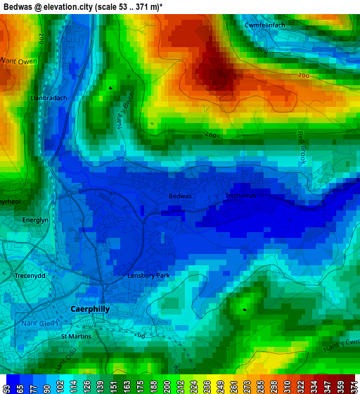
Below is the Elevation map of Bedwas, which displays elevation range with different colors. Scale of the first map is from 53 to 371 m (174 to 1217 ft) with average elevation of 144.8 meters (=475 ft) [note 1]
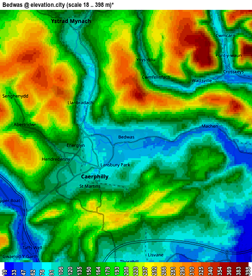
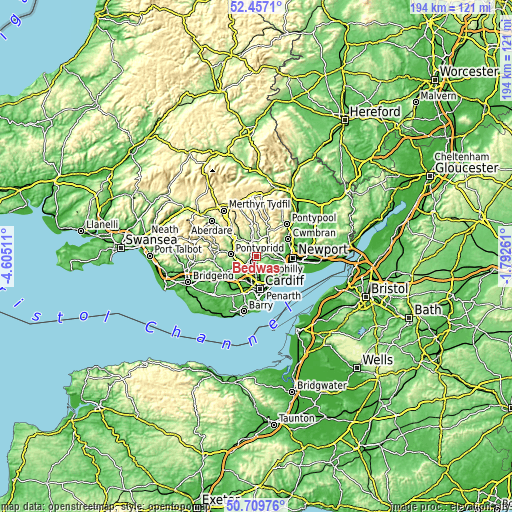
These maps also provides idea of topography and contour of this city, they are displayed at different zoom levels. More info about maps, scale and edge coordinates you can find below images.
| \ | Map #1 | Map #2 | Topo.Map |
| Scale [m] | 53..371 m | 18..398 m | × |
| Scale [ft] | 174..1217 ft | 59..1306 ft | × |
| Average | 144.8 m = 475 ft | 166.7 m = 547 ft | × |
| Width | 6.07 km = 3.8 mi | 12.14 km = 7.5 mi | 194.3 km = 120.7 mi |
| Height | 6.07 km = 3.8 mi | 12.14 km = 7.5 mi | 194.3 km = 120.7 mi |
| ↑Max Latitude | 51.619123° | 51.6464° | 52.4571° |
| Latitude at center | 51.59183° | 51.59183° | 51.59183° |
| ↓Min Latitude | 51.56452° | 51.537194° | 50.70976° |
| ← Min Longitude | -3.242805° | -3.286751° | -4.60511° |
| Longitude center | -3.19886° | -3.19886° | -3.19886° |
| →Max Longitude | -3.154915° | -3.110969° | -1.79261° |
Nearby cities:
Cities around Bedwas sort by population:
• Caerphilly elevation 94 m
2.3 km,  214°
214°
• Risca 49 m
7 km,  75°
75°
• Blackwood 227 m
8.5 km,  355°
355°
• Abercarn 103 m
7.6 km,  35°
35°
• Abertridwr 145 m
4.8 km,  275°
275°
• Hengoed 205 m
6.9 km,  340°
340°
• Llanbradach 95 m
2.7 km,  306°
306°
• Machen 55 m
4 km, 83°
• Pengam 134 m
8.4 km,  346°
346°
• Ystrad Mynach 115 m
6.2 km, 335°
• Crosskeys 63 m
6 km,  59°
59°
• Maesycwmmer 102 m
5.4 km,  334°
334°
Multilingual:
 En español:
Bedwas elevación 67 m.
 En France:
Bedwas élévation 67 m.


Sources and notes:
- [note 1] Map square and city borders are not equal. Map elevation data is calculated only from area inside that square.
- [src 1] Elevation data from geonames database provided with same terms of usage.
- [src 2] The elevation map of Bedwas is generated using elevation data from NASA's 3 arcsec (90m) resolution SRTM data.
- [src 3] Base (background) map © OpenStreetMap contributors tiles are generated by Geofabrik and OpenTopoMap.
Copyright & License:
This Bedwas Elevation Map is licensed under CC BY-SA. You may reuse any part from this page, if you give a proper credit by linking to this URL:
 More info on terms of use page.