Belford elevation
Belford (England, Northumberland), United Kingdom elevation is 56 meters and Belford elevation in feet is 184 ft above sea level [src 1]. Belford is a seat of a third-order administrative division (feature code) with elevation that is 16 meters (52 ft) smaller than average city elevation in United Kingdom.
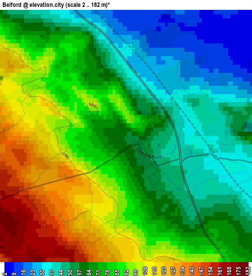
Below is the Elevation map of Belford, which displays elevation range with different colors. Scale of the first map is from 2 to 182 m (7 to 597 ft) with average elevation of 74 meters (=243 ft) [note 1]
These maps also provides idea of topography and contour of this city, they are displayed at different zoom levels. More info about maps, scale and edge coordinates you can find below images.
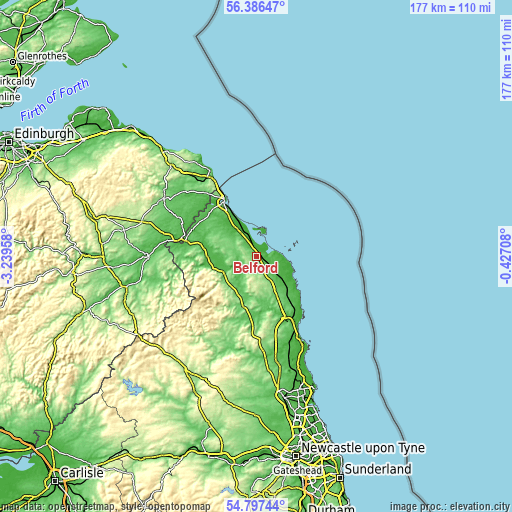
| \ | Map #1 | Topo.Map |
| Scale [m] | 2..182 m | × |
| Scale [ft] | 7..597 ft | × |
| Average | 74 m = 243 ft | × |
| Width | 5.52 km = 3.4 mi | 176.7 km = 109.8 mi |
| Height | 5.52 km = 3.4 mi | 176.7 km = 109.8 mi |
| ↑Max Latitude | 55.62482° | 56.38647° |
| Latitude at center | 55.6° | 55.6° |
| ↓Min Latitude | 55.575164° | 54.79744° |
| ← Min Longitude | -1.877275° | -3.23958° |
| Longitude center | -1.83333° | -1.83333° |
| →Max Longitude | -1.789385° | -0.42708° |
Nearby cities:
Cities around Belford sort by population:
• Wooler elevation 56 m
12.6 km,  242°
242°
• Seahouses 16 m
11.4 km,  100°
100°
• North Sunderland 20 m
10.9 km, 103°
• Embleton 44 m
17 km,  133°
133°
• Beadnell 8 m
13.5 km,  110°
110°
• Lowick 100 m
10.7 km,  301°
301°
• Bamburgh 26 m
7.3 km,  84°
84°
• Kirknewton 322 m
19.7 km,  253°
253°
• Ford 88 m
16.1 km,  283°
283°
• Ancroft 30 m
15.3 km,  316°
316°
• Doddington 53 m
10.9 km,  261°
261°
• Ellingham 74 m
10.3 km,  143°
143°
Multilingual:
 En español:
Belford elevación 56 m.
 En France:
Belford élévation 56 m.


Sources and notes:
- [note 1] Map square and city borders are not equal. Map elevation data is calculated only from area inside that square.
- [src 1] Elevation data from geonames database provided with same terms of usage.
- [src 2] The elevation map of Belford is generated using elevation data from NASA's 3 arcsec (90m) resolution SRTM data.
- [src 3] Base (background) map © OpenStreetMap contributors tiles are generated by Geofabrik and OpenTopoMap.
Copyright & License:
This Belford Elevation Map is licensed under CC BY-SA. You may reuse any part from this page, if you give a proper credit by linking to this URL:
 More info on terms of use page.