Bideford elevation
Bideford (England, Devon), United Kingdom elevation is 42 meters and Bideford elevation in feet is 138 ft above sea level [src 1]. Bideford is a populated place (feature code) with elevation that is 30 meters (98 ft) smaller than average city elevation in United Kingdom.
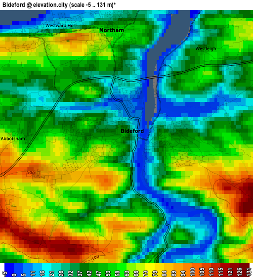
Below is the Elevation map of Bideford, which displays elevation range with different colors. Scale of the first map is from -5 to 131 m (-16 to 430 ft) with average elevation of 50.9 meters (=167 ft) [note 1]
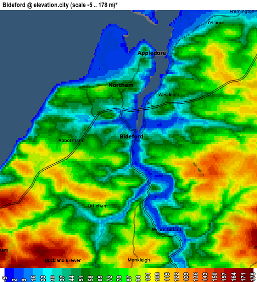
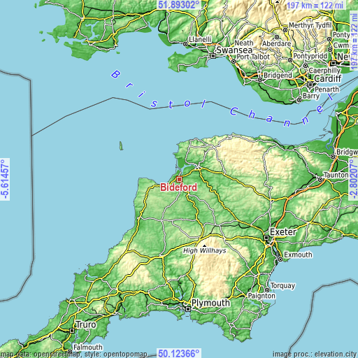
These maps also provides idea of topography and contour of this city, they are displayed at different zoom levels. More info about maps, scale and edge coordinates you can find below images.
| \ | Map #1 | Map #2 | Topo.Map |
| Scale [m] | -5..131 m | -5..178 m | × |
| Scale [ft] | -16..430 ft | -16..584 ft | × |
| Average | 50.9 m = 167 ft | 71.9 m = 236 ft | × |
| Width | 6.15 km = 3.8 mi | 12.3 km = 7.6 mi | 196.7 km = 122.2 mi |
| Height | 6.15 km = 3.8 mi | 12.3 km = 7.6 mi | 196.7 km = 122.2 mi |
| ↑Max Latitude | 51.044417° | 51.072038° | 51.89302° |
| Latitude at center | 51.01678° | 51.01678° | 51.01678° |
| ↓Min Latitude | 50.989126° | 50.961456° | 50.12366° |
| ← Min Longitude | -4.252265° | -4.296211° | -5.61457° |
| Longitude center | -4.20832° | -4.20832° | -4.20832° |
| →Max Longitude | -4.164375° | -4.120429° | -2.80207° |
Nearby cities:
Cities around Bideford sort by population:
• Barnstaple elevation 12 m
12.7 km,  56°
56°
• Ilfracombe 14 m
22.4 km,  17°
17°
• Braunton 14 m
10.7 km, 17°
• Northam 62 m
1.9 km,  342°
342°
• Great Torrington 99 m
8.4 km,  147°
147°
• South Molton 131 m
26.2 km,  90°
90°
• Fremington 25 m
7.7 km,  40°
40°
• Combe Martin 30 m
24 km,  32°
32°
• Holsworthy 138 m
25 km,  204°
204°
• Appledore 51 m
3.7 km,  8°
8°
• Hatherleigh 81 m
23.7 km,  156°
156°
• Winkleigh 168 m
25.8 km,  133°
133°
Multilingual:
 En español:
Bideford elevación 42 m.
 En France:
Bideford élévation 42 m.


Sources and notes:
- [note 1] Map square and city borders are not equal. Map elevation data is calculated only from area inside that square.
- [src 1] Elevation data from geonames database provided with same terms of usage.
- [src 2] The elevation map of Bideford is generated using elevation data from NASA's 3 arcsec (90m) resolution SRTM data.
- [src 3] Base (background) map © OpenStreetMap contributors tiles are generated by Geofabrik and OpenTopoMap.
Copyright & License:
This Bideford Elevation Map is licensed under CC BY-SA. You may reuse any part from this page, if you give a proper credit by linking to this URL:
 More info on terms of use page.