Burton upon Trent elevation
Burton upon Trent (England, Staffordshire), United Kingdom elevation is 49 meters and Burton upon Trent elevation in feet is 161 ft above sea level [src 1]. Burton upon Trent is a populated place (feature code) with elevation that is 23 meters (75 ft) smaller than average city elevation in United Kingdom.
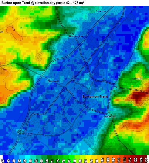
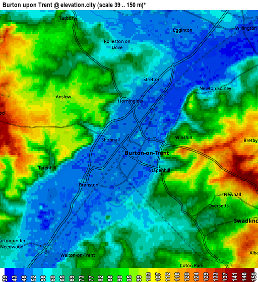
Below is the Elevation map of Burton upon Trent, which displays elevation range with different colors. Scale of the first map is from 42 to 127 m (138 to 417 ft) with average elevation of 63.8 meters (=209 ft) [note 1]
These maps also provides idea of topography and contour of this city, they are displayed at different zoom levels. More info about maps, scale and edge coordinates you can find below images.
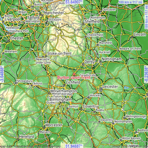
| \ | Map #1 | Map #2 | Topo.Map |
| Scale [m] | 42..127 m | 39..150 m | × |
| Scale [ft] | 138..417 ft | 128..492 ft | × |
| Average | 63.8 m = 209 ft | 73.6 m = 241 ft | × |
| Width | 5.91 km = 3.7 mi | 11.81 km = 7.3 mi | 189 km = 117.4 mi |
| Height | 5.91 km = 3.7 mi | 11.81 km = 7.3 mi | 189 km = 117.4 mi |
| ↑Max Latitude | 52.833837° | 52.860377° | 53.64907° |
| Latitude at center | 52.80728° | 52.80728° | 52.80728° |
| ↓Min Latitude | 52.780707° | 52.754118° | 51.94887° |
| ← Min Longitude | -1.686575° | -1.730521° | -3.04888° |
| Longitude center | -1.64263° | -1.64263° | -1.64263° |
| →Max Longitude | -1.598685° | -1.554739° | -0.23638° |
Nearby cities:
Cities around Burton upon Trent sort by population:
• Swadlincote elevation 98 m
6.8 km,  122°
122°
• Sinfin 61 m
13.3 km,  51°
51°
• Ashby de la Zouch 126 m
13.3 km, 120°
• Measham 105 m
14.5 km,  140°
140°
• Barton under Needwood 60 m
7.4 km,  227°
227°
• Alrewas 56 m
11 km,  221°
221°
• Repton 53 m
7.2 km,  59°
59°
• Etwall 76 m
8.9 km,  18°
18°
• Moira 97 m
10.7 km, 137°
• Donisthorpe 107 m
11.6 km, 142°
• Findern 59 m
9.6 km,  43°
43°
• Yoxall 66 m
10.9 km,  245°
245°
Multilingual:
 En español:
Burton upon Trent elevación 49 m.
 En France:
Burton upon Trent élévation 49 m.
 Auf Deutsch:
Burton-upon-Trent höhe über dem Meeresspiegel ist 49 m.

Sources and notes:
- [note 1] Map square and city borders are not equal. Map elevation data is calculated only from area inside that square.
- [src 1] Elevation data from geonames database provided with same terms of usage.
- [src 2] The elevation map of Burton upon Trent is generated using elevation data from NASA's 3 arcsec (90m) resolution SRTM data.
- [src 3] Base (background) map © OpenStreetMap contributors tiles are generated by Geofabrik and OpenTopoMap.
Copyright & License:
This Burton upon Trent Elevation Map is licensed under CC BY-SA. You may reuse any part from this page, if you give a proper credit by linking to this URL:
 More info on terms of use page.