Comrie elevation
Comrie (Scotland, Perth and Kinross), United Kingdom elevation is 61 meters and Comrie elevation in feet is 200 ft above sea level [src 1]. Comrie is a populated place (feature code) with elevation that is 11 meters (36 ft) smaller than average city elevation in United Kingdom.
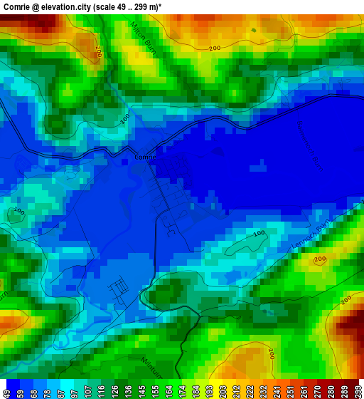
Below is the Elevation map of Comrie, which displays elevation range with different colors. Scale of the first map is from 49 to 299 m (161 to 981 ft) with average elevation of 117.1 meters (=384 ft) [note 1]
These maps also provides idea of topography and contour of this city, they are displayed at different zoom levels. More info about maps, scale and edge coordinates you can find below images.
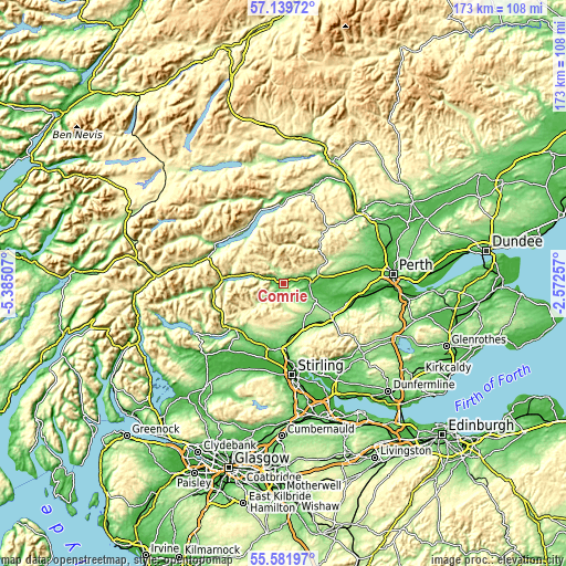
| \ | Map #1 | Topo.Map |
| Scale [m] | 49..299 m | × |
| Scale [ft] | 161..981 ft | × |
| Average | 117.1 m = 384 ft | × |
| Width | 5.41 km = 3.4 mi | 173.2 km = 107.6 mi |
| Height | 5.41 km = 3.4 mi | 173.2 km = 107.6 mi |
| ↑Max Latitude | 56.393131° | 57.13972° |
| Latitude at center | 56.3688° | 56.3688° |
| ↓Min Latitude | 56.344453° | 55.58197° |
| ← Min Longitude | -4.022765° | -5.38507° |
| Longitude center | -3.97882° | -3.97882° |
| →Max Longitude | -3.934875° | -2.57257° |
Nearby cities:
Cities around Comrie sort by population:
• Stirling elevation 24 m
27.9 km,  174°
174°
• Dunblane 64 m
20.1 km,  177°
177°
• Tullibody 33 m
27.5 km,  161°
161°
• Crieff 84 m
8.6 km,  87°
87°
• Tillicoultry 21 m
28.2 km,  148°
148°
• Bridge of Allan 13 m
24 km, 175°
• Alva 22 m
26.3 km, 155°
• Auchterarder 108 m
18.6 km,  115°
115°
• Callander 75 m
20.2 km,  226°
226°
• Menstrie 22 m
25.4 km, 162°
• Doune 40 m
20.4 km,  192°
192°
• Methven 77 m
25.2 km,  77°
77°
Multilingual:
 En español:
Comrie elevación 61 m.
 En France:
Comrie élévation 61 m.


Sources and notes:
- [note 1] Map square and city borders are not equal. Map elevation data is calculated only from area inside that square.
- [src 1] Elevation data from geonames database provided with same terms of usage.
- [src 2] The elevation map of Comrie is generated using elevation data from NASA's 3 arcsec (90m) resolution SRTM data.
- [src 3] Base (background) map © OpenStreetMap contributors tiles are generated by Geofabrik and OpenTopoMap.
Copyright & License:
This Comrie Elevation Map is licensed under CC BY-SA. You may reuse any part from this page, if you give a proper credit by linking to this URL:
 More info on terms of use page.