Dalmellington elevation
Dalmellington (Scotland, East Ayrshire), United Kingdom elevation is 170 meters and Dalmellington elevation in feet is 558 ft above sea level [src 1]. Dalmellington is a populated place (feature code) with elevation that is 98 meters (322 ft) bigger than average city elevation in United Kingdom.
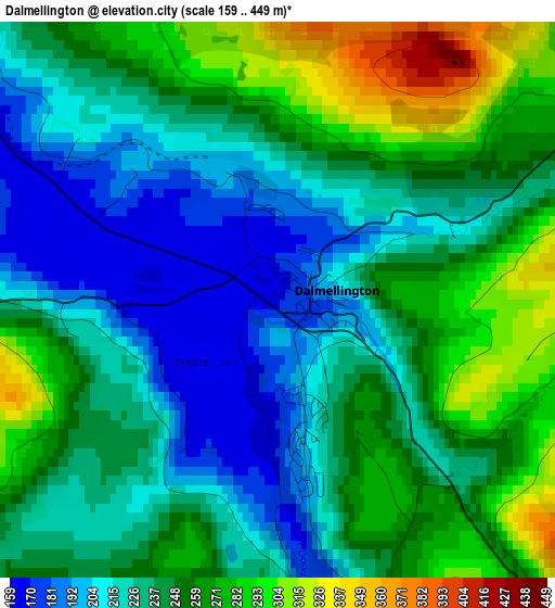
Below is the Elevation map of Dalmellington, which displays elevation range with different colors. Scale of the first map is from 159 to 449 m (522 to 1473 ft) with average elevation of 241.9 meters (=794 ft) [note 1]
These maps also provides idea of topography and contour of this city, they are displayed at different zoom levels. More info about maps, scale and edge coordinates you can find below images.
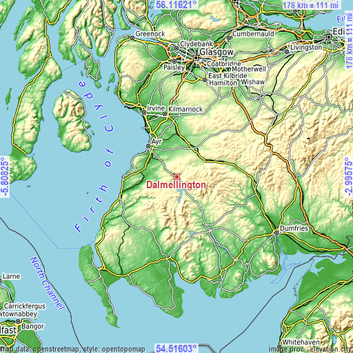
| \ | Map #1 | Topo.Map |
| Scale [m] | 159..449 m | × |
| Scale [ft] | 522..1473 ft | × |
| Average | 241.9 m = 794 ft | × |
| Width | 5.56 km = 3.5 mi | 177.9 km = 110.5 mi |
| Height | 5.56 km = 3.5 mi | 177.9 km = 110.5 mi |
| ↑Max Latitude | 55.349184° | 56.11621° |
| Latitude at center | 55.32419° | 55.32419° |
| ↓Min Latitude | 55.29918° | 54.51603° |
| ← Min Longitude | -4.445945° | -5.80825° |
| Longitude center | -4.402° | -4.402° |
| →Max Longitude | -4.358055° | -2.99575° |
Nearby cities:
Cities around Dalmellington sort by population:
• Cumnock elevation 115 m
16.8 km,  30°
30°
• Maybole 84 m
17.9 km,  281°
281°
• Auchinleck 157 m
17.8 km,  22°
22°
• Drongan 106 m
12.8 km,  344°
344°
• New Cumnock 187 m
15.9 km,  59°
59°
• Patna 171 m
7.9 km,  304°
304°
• Coylton 73 m
15.4 km,  331°
331°
• Mossblown 50 m
20 km, 336°
• Dalrymple 56 m
14.5 km, 304°
• Bellsbank 194 m
1.3 km,  170°
170°
• Logan 164 m
17.9 km,  35°
35°
• Ochiltree 132 m
15.2 km,  8°
8°
Multilingual:
 En español:
Dalmellington elevación 170 m.
 En France:
Dalmellington élévation 170 m.
 Auf Deutsch:
Dalmellington höhe über dem Meeresspiegel ist 170 m.

Sources and notes:
- [note 1] Map square and city borders are not equal. Map elevation data is calculated only from area inside that square.
- [src 1] Elevation data from geonames database provided with same terms of usage.
- [src 2] The elevation map of Dalmellington is generated using elevation data from NASA's 3 arcsec (90m) resolution SRTM data.
- [src 3] Base (background) map © OpenStreetMap contributors tiles are generated by Geofabrik and OpenTopoMap.
Copyright & License:
This Dalmellington Elevation Map is licensed under CC BY-SA. You may reuse any part from this page, if you give a proper credit by linking to this URL:
 More info on terms of use page.