Darfield elevation
Darfield (England, Barnsley), United Kingdom elevation is 64 meters and Darfield elevation in feet is 210 ft above sea level [src 1]. Darfield is a populated place (feature code) with elevation that is 8 meters (26 ft) smaller than average city elevation in United Kingdom.
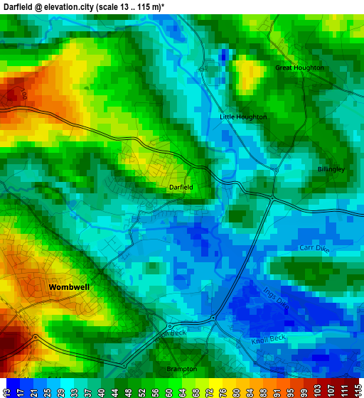
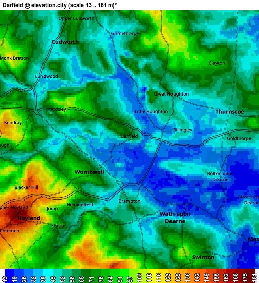
Below is the Elevation map of Darfield, which displays elevation range with different colors. Scale of the first map is from 13 to 115 m (43 to 377 ft) with average elevation of 46.1 meters (=151 ft) [note 1]
These maps also provides idea of topography and contour of this city, they are displayed at different zoom levels. More info about maps, scale and edge coordinates you can find below images.
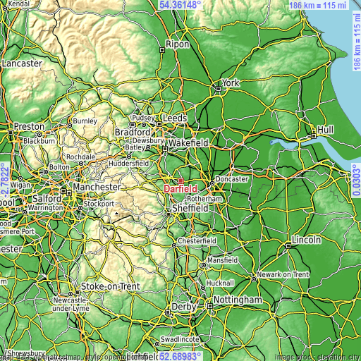
| \ | Map #1 | Map #2 | Topo.Map |
| Scale [m] | 13..115 m | 13..181 m | × |
| Scale [ft] | 43..377 ft | 43..594 ft | × |
| Average | 46.1 m = 151 ft | 61.5 m = 202 ft | × |
| Width | 5.81 km = 3.6 mi | 11.62 km = 7.2 mi | 185.9 km = 115.5 mi |
| Height | 5.81 km = 3.6 mi | 11.62 km = 7.2 mi | 185.9 km = 115.5 mi |
| ↑Max Latitude | 53.560011° | 53.586105° | 54.36148° |
| Latitude at center | 53.5339° | 53.5339° | 53.5339° |
| ↓Min Latitude | 53.507773° | 53.48163° | 52.68983° |
| ← Min Longitude | -1.419895° | -1.463841° | -2.7822° |
| Longitude center | -1.37595° | -1.37595° | -1.37595° |
| →Max Longitude | -1.332005° | -1.288059° | 0.0303° |
Nearby cities:
Cities around Darfield sort by population:
• Wath upon Dearne elevation 35 m
4 km,  149°
149°
• Hoyland Nether 162 m
6.2 km,  232°
232°
• Wombwell 53 m
1.9 km, 226°
• Mexborough 28 m
7.1 km,  128°
128°
• Bolton upon Dearne 31 m
4.4 km,  116°
116°
• Cudworth 68 m
4.9 km,  327°
327°
• Grimethorpe 49 m
4.7 km,  359°
359°
• Great Houghton 62 m
2.8 km,  38°
38°
• Barnburgh 49 m
6.9 km,  99°
99°
• Wentworth 115 m
6.7 km,  202°
202°
• Shafton 82 m
6.9 km,  341°
341°
• Little Houghton 50 m
1.7 km, 38°
Multilingual:
 En español:
Darfield elevación 64 m.
 En France:
Darfield élévation 64 m.


Sources and notes:
- [note 1] Map square and city borders are not equal. Map elevation data is calculated only from area inside that square.
- [src 1] Elevation data from geonames database provided with same terms of usage.
- [src 2] The elevation map of Darfield is generated using elevation data from NASA's 3 arcsec (90m) resolution SRTM data.
- [src 3] Base (background) map © OpenStreetMap contributors tiles are generated by Geofabrik and OpenTopoMap.
Copyright & License:
This Darfield Elevation Map is licensed under CC BY-SA. You may reuse any part from this page, if you give a proper credit by linking to this URL:
 More info on terms of use page.