Drighlington elevation
Drighlington (England, City and Borough of Leeds), United Kingdom elevation is 182 meters and Drighlington elevation in feet is 597 ft above sea level [src 1]. Drighlington is a seat of a third-order administrative division (feature code) with elevation that is 110 meters (361 ft) bigger than average city elevation in United Kingdom.
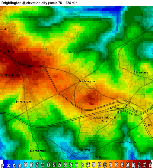
Below is the Elevation map of Drighlington, which displays elevation range with different colors. Scale of the first map is from 78 to 224 m (256 to 735 ft) with average elevation of 151.9 meters (=498 ft) [note 1]
These maps also provides idea of topography and contour of this city, they are displayed at different zoom levels. More info about maps, scale and edge coordinates you can find below images.
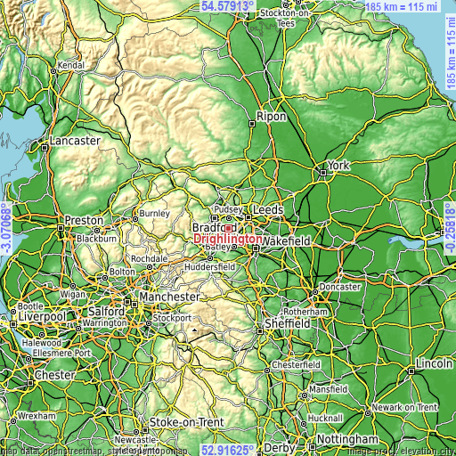
| \ | Map #1 | Topo.Map |
| Scale [m] | 78..224 m | × |
| Scale [ft] | 256..735 ft | × |
| Average | 151.9 m = 498 ft | × |
| Width | 5.78 km = 3.6 mi | 184.9 km = 114.9 mi |
| Height | 5.78 km = 3.6 mi | 184.9 km = 114.9 mi |
| ↑Max Latitude | 53.781894° | 54.57913° |
| Latitude at center | 53.75592° | 53.75592° |
| ↓Min Latitude | 53.72993° | 52.91625° |
| ← Min Longitude | -1.708375° | -3.07068° |
| Longitude center | -1.66443° | -1.66443° |
| →Max Longitude | -1.620485° | -0.25818° |
Nearby cities:
Cities around Drighlington sort by population:
• Leeds elevation 50 m
8.9 km,  59°
59°
• Bradford 110 m
7.1 km,  306°
306°
• Morley 148 m
4.7 km,  112°
112°
• Dewsbury 44 m
7.6 km,  162°
162°
• Batley 58 m
6.2 km, 161°
• Pudsey 163 m
4.4 km,  2°
2°
• Cleckheaton 92 m
4.8 km,  221°
221°
• Mirfield 47 m
9.4 km,  192°
192°
• Liversedge 103 m
6 km,  198°
198°
• Heckmondwike 61 m
5.6 km, 188°
• Holbeck 39 m
7 km, 64°
• Gildersome 139 m
2.3 km,  74°
74°
Multilingual:
 En español:
Drighlington elevación 182 m.
 En France:
Drighlington élévation 182 m.
 Auf Deutsch:
Drighlington höhe über dem Meeresspiegel ist 182 m.

Sources and notes:
- [note 1] Map square and city borders are not equal. Map elevation data is calculated only from area inside that square.
- [src 1] Elevation data from geonames database provided with same terms of usage.
- [src 2] The elevation map of Drighlington is generated using elevation data from NASA's 3 arcsec (90m) resolution SRTM data.
- [src 3] Base (background) map © OpenStreetMap contributors tiles are generated by Geofabrik and OpenTopoMap.
Copyright & License:
This Drighlington Elevation Map is licensed under CC BY-SA. You may reuse any part from this page, if you give a proper credit by linking to this URL:
 More info on terms of use page.