Dunbar elevation
Dunbar (Scotland, East Lothian), United Kingdom elevation is 21 meters and Dunbar elevation in feet is 69 ft above sea level [src 1]. Dunbar is a populated place (feature code) with elevation that is 51 meters (167 ft) smaller than average city elevation in United Kingdom.
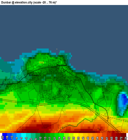
Below is the Elevation map of Dunbar, which displays elevation range with different colors. Scale of the first map is from -20 to 76 m (-66 to 249 ft) with average elevation of 26.1 meters (=86 ft) [note 1]
These maps also provides idea of topography and contour of this city, they are displayed at different zoom levels. More info about maps, scale and edge coordinates you can find below images.
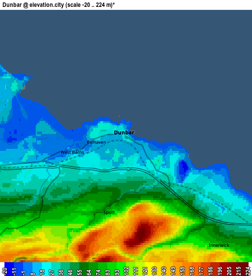
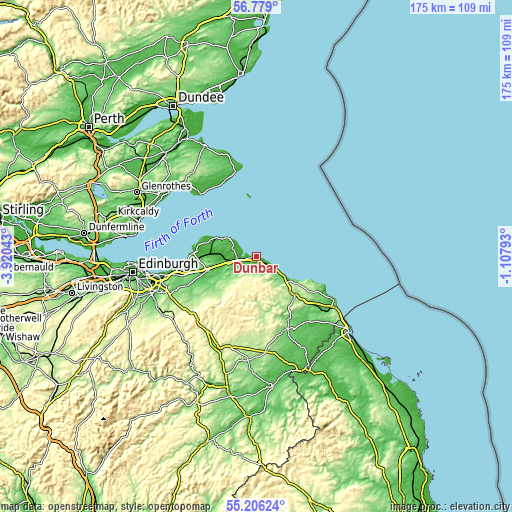
| \ | Map #1 | Map #2 | Topo.Map |
| Scale [m] | -20..76 m | -20..224 m | × |
| Scale [ft] | -66..249 ft | -66..735 ft | × |
| Average | 26.1 m = 86 ft | 63.1 m = 207 ft | × |
| Width | 5.46 km = 3.4 mi | 10.93 km = 6.8 mi | 174.9 km = 108.7 mi |
| Height | 5.46 km = 3.4 mi | 10.93 km = 6.8 mi | 174.9 km = 108.7 mi |
| ↑Max Latitude | 56.025186° | 56.049736° | 56.779° |
| Latitude at center | 56.00062° | 56.00062° | 56.00062° |
| ↓Min Latitude | 55.976039° | 55.951442° | 55.20624° |
| ← Min Longitude | -2.558125° | -2.602071° | -3.92043° |
| Longitude center | -2.51418° | -2.51418° | -2.51418° |
| →Max Longitude | -2.470235° | -2.426289° | -1.10793° |
Nearby cities:
Cities around Dunbar sort by population:
• Haddington elevation 55 m
17.5 km,  253°
253°
• North Berwick 8 m
14.5 km,  296°
296°
• Anstruther 13 m
27.4 km,  334°
334°
• Duns 134 m
27 km,  157°
157°
• Gullane 34 m
19.9 km,  281°
281°
• Longniddry 22 m
23.9 km,  263°
263°
• East Linton 25 m
9 km, 260°
• Pittenweem 26 m
27.2 km, 330°
• Pencaitland 90 m
25.9 km, 246°
• Macmerry 95 m
25.2 km, 254°
• Saint Monans 19 m
27.8 km, 325°
• Aberlady 12 m
21.4 km,  272°
272°
Multilingual:
 En español:
Dunbar elevación 21 m.
 En France:
Dunbar élévation 21 m.


Sources and notes:
- [note 1] Map square and city borders are not equal. Map elevation data is calculated only from area inside that square.
- [src 1] Elevation data from geonames database provided with same terms of usage.
- [src 2] The elevation map of Dunbar is generated using elevation data from NASA's 3 arcsec (90m) resolution SRTM data.
- [src 3] Base (background) map © OpenStreetMap contributors tiles are generated by Geofabrik and OpenTopoMap.
Copyright & License:
This Dunbar Elevation Map is licensed under CC BY-SA. You may reuse any part from this page, if you give a proper credit by linking to this URL:
 More info on terms of use page.