Dursley elevation
Dursley (England, Gloucestershire), United Kingdom elevation is 73 meters and Dursley elevation in feet is 240 ft above sea level [src 1]. Dursley is a populated place (feature code) with elevation that is 1 meters (3 ft) bigger than average city elevation in United Kingdom.
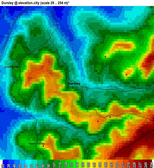
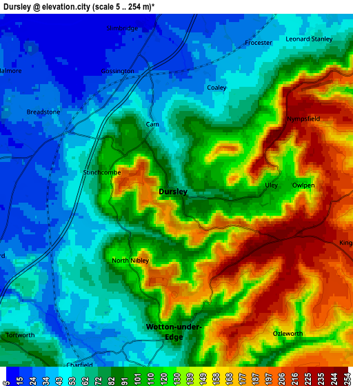
Below is the Elevation map of Dursley, which displays elevation range with different colors. Scale of the first map is from 29 to 254 m (95 to 833 ft) with average elevation of 113.1 meters (=371 ft) [note 1]
These maps also provides idea of topography and contour of this city, they are displayed at different zoom levels. More info about maps, scale and edge coordinates you can find below images.
| \ | Map #1 | Map #2 | Topo.Map |
| Scale [m] | 29..254 m | 5..254 m | × |
| Scale [ft] | 95..833 ft | 16..833 ft | × |
| Average | 113.1 m = 371 ft | 95.9 m = 315 ft | × |
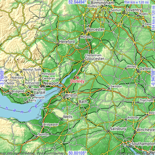
| Width | 6.06 km = 3.8 mi | 12.12 km = 7.5 mi | 193.9 km = 120.5 mi |
| Height | 6.06 km = 3.8 mi | 12.12 km = 7.5 mi | 193.9 km = 120.5 mi |
| ↑Max Latitude | 51.708629° | 51.735852° | 52.54494° |
| Latitude at center | 51.68139° | 51.68139° | 51.68139° |
| ↓Min Latitude | 51.654134° | 51.626862° | 50.80105° |
| ← Min Longitude | -2.397275° | -2.441221° | -3.75958° |
| Longitude center | -2.35333° | -2.35333° | -2.35333° |
| →Max Longitude | -2.309385° | -2.265439° | -0.94708° |
Nearby cities:
Cities around Dursley sort by population:
• Stonehouse elevation 42 m
9 km,  32°
32°
• Wotton-under-Edge 82 m
5.5 km,  174°
174°
• Nailsworth 67 m
9.3 km,  81°
81°
• Charfield 49 m
7.1 km,  211°
211°
• Berkeley 21 m
7.4 km,  278°
278°
• Wickwar 83 m
10.2 km,  198°
198°
• Frampton on Severn 12 m
9.9 km,  355°
355°
• Kingswood 49 m
6.3 km,  188°
188°
• Eastington 32 m
7.6 km,  14°
14°
• Sharpness 13 m
9.6 km,  296°
296°
• Hill 7 m
11.7 km,  253°
253°
• Falfield 30 m
8.9 km,  236°
236°
Multilingual:
 En español:
Dursley elevación 73 m.
 En France:
Dursley élévation 73 m.


Sources and notes:
- [note 1] Map square and city borders are not equal. Map elevation data is calculated only from area inside that square.
- [src 1] Elevation data from geonames database provided with same terms of usage.
- [src 2] The elevation map of Dursley is generated using elevation data from NASA's 3 arcsec (90m) resolution SRTM data.
- [src 3] Base (background) map © OpenStreetMap contributors tiles are generated by Geofabrik and OpenTopoMap.
Copyright & License:
This Dursley Elevation Map is licensed under CC BY-SA. You may reuse any part from this page, if you give a proper credit by linking to this URL:
 More info on terms of use page.