East Dean elevation
East Dean (England, Hampshire), United Kingdom elevation is 38 meters and East Dean elevation in feet is 125 ft above sea level [src 1]. East Dean is a populated place (feature code) with elevation that is 34 meters (112 ft) smaller than average city elevation in United Kingdom.
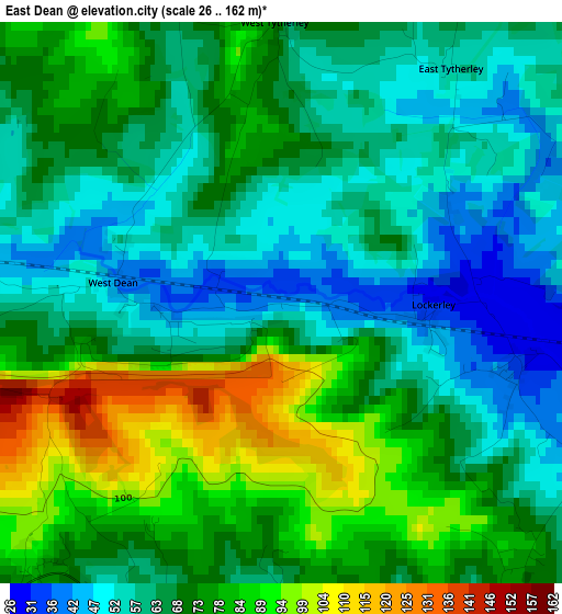
Below is the Elevation map of East Dean, which displays elevation range with different colors. Scale of the first map is from 26 to 162 m (85 to 531 ft) with average elevation of 68.8 meters (=226 ft) [note 1]
These maps also provides idea of topography and contour of this city, they are displayed at different zoom levels. More info about maps, scale and edge coordinates you can find below images.
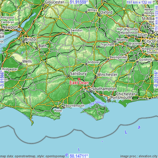
| \ | Map #1 | Topo.Map |
| Scale [m] | 26..162 m | × |
| Scale [ft] | 85..531 ft | × |
| Average | 68.8 m = 226 ft | × |
| Width | 6.14 km = 3.8 mi | 196.6 km = 122.2 mi |
| Height | 6.14 km = 3.8 mi | 196.6 km = 122.2 mi |
| ↑Max Latitude | 51.067414° | 51.91559° |
| Latitude at center | 51.03979° | 51.03979° |
| ↓Min Latitude | 51.01215° | 50.14711° |
| ← Min Longitude | -1.653355° | -3.01566° |
| Longitude center | -1.60941° | -1.60941° |
| →Max Longitude | -1.565465° | -0.20316° |
Nearby cities:
Cities around East Dean sort by population:
• Salisbury elevation 50 m
13.4 km,  284°
284°
• Totton 5 m
15.8 km,  148°
148°
• Romsey 20 m
9.5 km,  126°
126°
• North Baddesley 43 m
13.4 km,  121°
121°
• West Wellow 25 m
7.7 km,  166°
166°
• Downton 35 m
11.2 km,  242°
242°
• Alderbury 94 m
8.7 km,  272°
272°
• Abbotts Ann 64 m
17.6 km,  17°
17°
• Cadnam 30 m
13.4 km, 171°
• Middle Winterslow 125 m
6.7 km,  332°
332°
• Whiteparish 74 m
4.3 km,  219°
219°
• Allington 103 m
13.8 km, 332°
Multilingual:
 En español:
East Dean elevación 38 m.
 En France:
East Dean élévation 38 m.
 Auf Deutsch:
East Dean höhe über dem Meeresspiegel ist 38 m.

Sources and notes:
- [note 1] Map square and city borders are not equal. Map elevation data is calculated only from area inside that square.
- [src 1] Elevation data from geonames database provided with same terms of usage.
- [src 2] The elevation map of East Dean is generated using elevation data from NASA's 3 arcsec (90m) resolution SRTM data.
- [src 3] Base (background) map © OpenStreetMap contributors tiles are generated by Geofabrik and OpenTopoMap.
Copyright & License:
This East Dean Elevation Map is licensed under CC BY-SA. You may reuse any part from this page, if you give a proper credit by linking to this URL:
 More info on terms of use page.