Glusburn elevation
Glusburn (England, North Yorkshire), United Kingdom elevation is 116 meters and Glusburn elevation in feet is 381 ft above sea level [src 1]. Glusburn is a populated place (feature code) with elevation that is 44 meters (144 ft) bigger than average city elevation in United Kingdom.
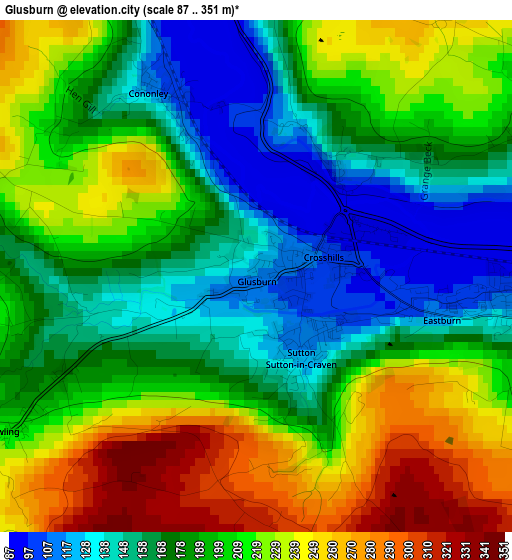
Below is the Elevation map of Glusburn, which displays elevation range with different colors. Scale of the first map is from 87 to 351 m (285 to 1152 ft) with average elevation of 195.4 meters (=641 ft) [note 1]
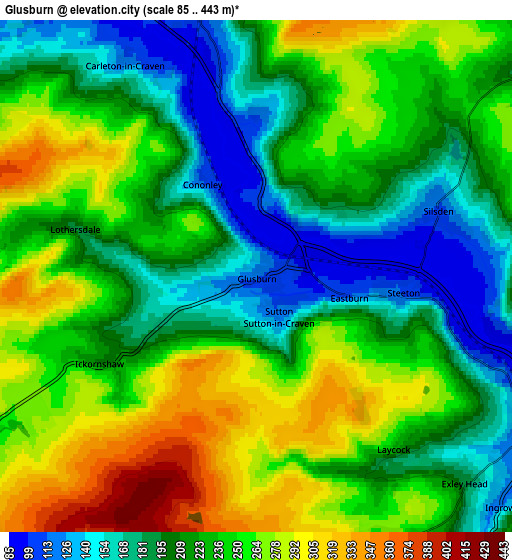
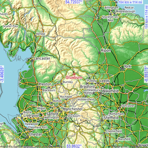
These maps also provides idea of topography and contour of this city, they are displayed at different zoom levels. More info about maps, scale and edge coordinates you can find below images.
| \ | Map #1 | Map #2 | Topo.Map |
| Scale [m] | 87..351 m | 85..443 m | × |
| Scale [ft] | 285..1152 ft | 279..1453 ft | × |
| Average | 195.4 m = 641 ft | 228.5 m = 750 ft | × |
| Width | 5.76 km = 3.6 mi | 11.52 km = 7.2 mi | 184.3 km = 114.5 mi |
| Height | 5.76 km = 3.6 mi | 11.52 km = 7.2 mi | 184.2 km = 114.5 mi |
| ↑Max Latitude | 53.925884° | 53.951753° | 54.72037° |
| Latitude at center | 53.9° | 53.9° | 53.9° |
| ↓Min Latitude | 53.8741° | 53.848183° | 53.0632° |
| ← Min Longitude | -2.043945° | -2.087891° | -3.40625° |
| Longitude center | -2° | -2° | -2° |
| →Max Longitude | -1.956055° | -1.912109° | -0.59375° |
Nearby cities:
Cities around Glusburn sort by population:
• Keighley elevation 108 m
7.1 km,  120°
120°
• Skipton 113 m
6.9 km,  350°
350°
• Cross Hills 93 m
1.2 km,  55°
55°
• Silsden 115 m
4.4 km,  68°
68°
• Haworth 177 m
8.6 km,  156°
156°
• Earby 138 m
9.5 km,  280°
280°
• Steeton 244 m
3.8 km, 119°
• Addingham 108 m
9.1 km, 56°
• Cullingworth 205 m
10.8 km,  141°
141°
• Oxenhope 212 m
10.2 km, 162°
• Embsay 147 m
8.5 km,  3°
3°
• Low Bradley 118 m
3.6 km, 3°
Multilingual:
 En español:
Glusburn elevación 116 m.
 En France:
Glusburn élévation 116 m.
 Auf Deutsch:
Glusburn höhe über dem Meeresspiegel ist 116 m.

Sources and notes:
- [note 1] Map square and city borders are not equal. Map elevation data is calculated only from area inside that square.
- [src 1] Elevation data from geonames database provided with same terms of usage.
- [src 2] The elevation map of Glusburn is generated using elevation data from NASA's 3 arcsec (90m) resolution SRTM data.
- [src 3] Base (background) map © OpenStreetMap contributors tiles are generated by Geofabrik and OpenTopoMap.
Copyright & License:
This Glusburn Elevation Map is licensed under CC BY-SA. You may reuse any part from this page, if you give a proper credit by linking to this URL:
 More info on terms of use page.