Hartlepool elevation
Hartlepool (England), United Kingdom elevation is 1 meters and Hartlepool elevation in feet is 3 ft above sea level [src 1]. Hartlepool is a seat of a second-order administrative division (feature code) with elevation that is 71 meters (233 ft) smaller than average city elevation in United Kingdom.
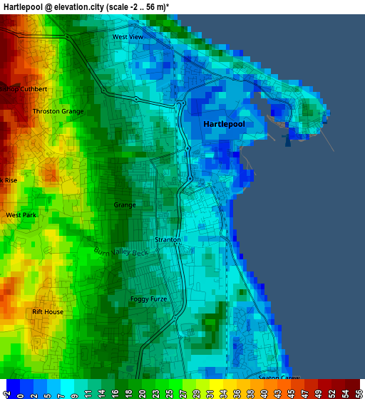
Below is the Elevation map of Hartlepool, which displays elevation range with different colors. Scale of the first map is from -2 to 56 m (-7 to 184 ft) with average elevation of 17.8 meters (=58 ft) [note 1]
These maps also provides idea of topography and contour of this city, they are displayed at different zoom levels. More info about maps, scale and edge coordinates you can find below images.
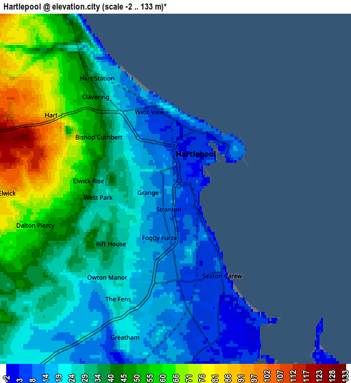
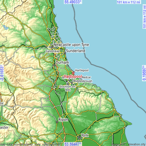
| \ | Map #1 | Map #2 | Topo.Map |
| Scale [m] | -2..56 m | -2..133 m | × |
| Scale [ft] | -7..184 ft | -7..436 ft | × |
| Average | 17.8 m = 58 ft | 34.3 m = 113 ft | × |
| Width | 5.65 km = 3.5 mi | 11.3 km = 7 mi | 180.8 km = 112.3 mi |
| Height | 5.65 km = 3.5 mi | 11.3 km = 7 mi | 180.8 km = 112.3 mi |
| ↑Max Latitude | 54.710935° | 54.736315° | 55.49033° |
| Latitude at center | 54.68554° | 54.68554° | 54.68554° |
| ↓Min Latitude | 54.660129° | 54.634702° | 53.86447° |
| ← Min Longitude | -1.254225° | -1.298171° | -2.61653° |
| Longitude center | -1.21028° | -1.21028° | -1.21028° |
| →Max Longitude | -1.166335° | -1.122389° | 0.19597° |
Nearby cities:
Cities around Hartlepool sort by population:
• Middlesbrough elevation 15 m
12.3 km,  187°
187°
• Redcar 9 m
12.3 km,  128°
128°
• Peterlee 101 m
11.6 km,  315°
315°
• Billingham 13 m
11.9 km,  205°
205°
• Wingate 132 m
12 km,  295°
295°
• Trimdon 144 m
14.1 km,  275°
275°
• Trimdon Grange 140 m
14.2 km, 282°
• Greatham 19 m
5.2 km,  200°
200°
• Elwick 88 m
5.5 km,  268°
268°
• South Bank 22 m
13.8 km,  163°
163°
• Easington Colliery 89 m
13.7 km,  326°
326°
• Grindon 67 m
13.5 km,  235°
235°
Multilingual:
 En español:
Hartlepool elevación 1 m.
 En France:
Hartlepool élévation 1 m.
 Auf Deutsch:
Hartlepool höhe über dem Meeresspiegel ist 1 m.

Sources and notes:
- [note 1] Map square and city borders are not equal. Map elevation data is calculated only from area inside that square.
- [src 1] Elevation data from geonames database provided with same terms of usage.
- [src 2] The elevation map of Hartlepool is generated using elevation data from NASA's 3 arcsec (90m) resolution SRTM data.
- [src 3] Base (background) map © OpenStreetMap contributors tiles are generated by Geofabrik and OpenTopoMap.
Copyright & License:
This Hartlepool Elevation Map is licensed under CC BY-SA. You may reuse any part from this page, if you give a proper credit by linking to this URL:
 More info on terms of use page.