Hartwell elevation
Hartwell (England, Northamptonshire), United Kingdom elevation is 121 meters and Hartwell elevation in feet is 397 ft above sea level [src 1]. Hartwell is a populated place (feature code) with elevation that is 49 meters (161 ft) bigger than average city elevation in United Kingdom.
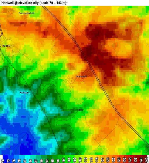
Below is the Elevation map of Hartwell, which displays elevation range with different colors. Scale of the first map is from 70 to 143 m (230 to 469 ft) with average elevation of 110.5 meters (=363 ft) [note 1]
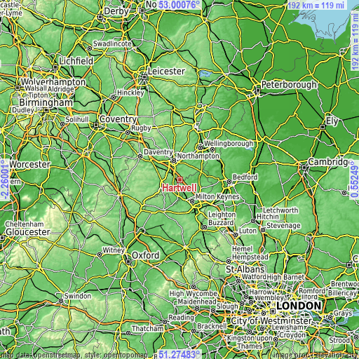
These maps also provides idea of topography and contour of this city, they are displayed at different zoom levels. More info about maps, scale and edge coordinates you can find below images.
| \ | Map #1 | Topo.Map |
| Scale [m] | 70..143 m | × |
| Scale [ft] | 230..469 ft | × |
| Average | 110.5 m = 363 ft | × |
| Width | 6 km = 3.7 mi | 191.9 km = 119.2 mi |
| Height | 6 km = 3.7 mi | 191.9 km = 119.2 mi |
| ↑Max Latitude | 52.173119° | 53.00076° |
| Latitude at center | 52.14616° | 52.14616° |
| ↓Min Latitude | 52.119185° | 51.27483° |
| ← Min Longitude | -0.897705° | -2.26001° |
| Longitude center | -0.85376° | -0.85376° |
| →Max Longitude | -0.809815° | 0.55249° |
Nearby cities:
Cities around Hartwell sort by population:
• Towcester elevation 94 m
9.4 km,  261°
261°
• Hardingstone 106 m
7.8 km,  343°
343°
• Roade 114 m
3.3 km,  294°
294°
• Hanslope 119 m
4 km,  152°
152°
• Blisworth 97 m
6.8 km,  298°
298°
• Potterspury 91 m
7.6 km,  202°
202°
• Hackleton 94 m
5.1 km,  24°
24°
• Stoke Goldington 68 m
5.4 km,  107°
107°
• Weston Underwood 76 m
7.9 km,  90°
90°
• Gayhurst 70 m
7.2 km,  120°
120°
• Ravenstone 88 m
6.5 km, 86°
• Castlethorpe 88 m
6.1 km,  168°
168°
Multilingual:
 En español:
Hartwell elevación 121 m.
 En France:
Hartwell élévation 121 m.
 Auf Deutsch:
Hartwell höhe über dem Meeresspiegel ist 121 m.

Sources and notes:
- [note 1] Map square and city borders are not equal. Map elevation data is calculated only from area inside that square.
- [src 1] Elevation data from geonames database provided with same terms of usage.
- [src 2] The elevation map of Hartwell is generated using elevation data from NASA's 3 arcsec (90m) resolution SRTM data.
- [src 3] Base (background) map © OpenStreetMap contributors tiles are generated by Geofabrik and OpenTopoMap.
Copyright & License:
This Hartwell Elevation Map is licensed under CC BY-SA. You may reuse any part from this page, if you give a proper credit by linking to this URL:
 More info on terms of use page.