Kenilworth elevation
Kenilworth (England, Warwickshire), United Kingdom elevation is 88 meters and Kenilworth elevation in feet is 289 ft above sea level [src 1]. Kenilworth is a populated place (feature code) with elevation that is 16 meters (52 ft) bigger than average city elevation in United Kingdom.
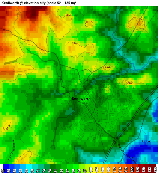
Below is the Elevation map of Kenilworth, which displays elevation range with different colors. Scale of the first map is from 52 to 135 m (171 to 443 ft) with average elevation of 88.9 meters (=292 ft) [note 1]
These maps also provides idea of topography and contour of this city, they are displayed at different zoom levels. More info about maps, scale and edge coordinates you can find below images.
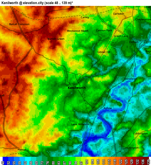
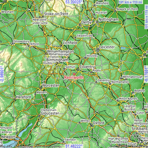
| \ | Map #1 | Map #2 | Topo.Map |
| Scale [m] | 52..135 m | 48..139 m | × |
| Scale [ft] | 171..443 ft | 157..456 ft | × |
| Average | 88.9 m = 292 ft | 93.4 m = 306 ft | × |
| Width | 5.97 km = 3.7 mi | 11.94 km = 7.4 mi | 191 km = 118.7 mi |
| Height | 5.97 km = 3.7 mi | 11.94 km = 7.4 mi | 191 km = 118.7 mi |
| ↑Max Latitude | 52.376415° | 52.403235° | 53.20025° |
| Latitude at center | 52.34958° | 52.34958° | 52.34958° |
| ↓Min Latitude | 52.322728° | 52.29586° | 51.48222° |
| ← Min Longitude | -1.626705° | -1.670651° | -2.98901° |
| Longitude center | -1.58276° | -1.58276° | -1.58276° |
| →Max Longitude | -1.538815° | -1.494869° | -0.17651° |
Nearby cities:
Cities around Kenilworth sort by population:
• Coventry elevation 89 m
7.9 km,  37°
37°
• Royal Leamington Spa 74 m
8.3 km,  149°
149°
• Warwick 57 m
7.4 km,  180°
180°
• Knowle 124 m
10.9 km,  290°
290°
• Balsall Common 124 m
6.6 km,  315°
315°
• Hatton 100 m
6.5 km,  211°
211°
• Wroxall 131 m
6 km,  257°
257°
• Ryton on Dunsmore 80 m
10.3 km,  79°
79°
• Meriden 121 m
10.6 km,  337°
337°
• Leek Wootton 90 m
3.5 km, 176°
• Barston 118 m
9.5 km,  306°
306°
• Berkswell 108 m
7.7 km,  328°
328°
Multilingual:
 En español:
Kenilworth elevación 88 m.
 En France:
Kenilworth élévation 88 m.
 Auf Deutsch:
Kenilworth höhe über dem Meeresspiegel ist 88 m.

Sources and notes:
- [note 1] Map square and city borders are not equal. Map elevation data is calculated only from area inside that square.
- [src 1] Elevation data from geonames database provided with same terms of usage.
- [src 2] The elevation map of Kenilworth is generated using elevation data from NASA's 3 arcsec (90m) resolution SRTM data.
- [src 3] Base (background) map © OpenStreetMap contributors tiles are generated by Geofabrik and OpenTopoMap.
Copyright & License:
This Kenilworth Elevation Map is licensed under CC BY-SA. You may reuse any part from this page, if you give a proper credit by linking to this URL:
 More info on terms of use page.