Kirkburton elevation
Kirkburton (England, Kirklees), United Kingdom elevation is 129 meters and Kirkburton elevation in feet is 423 ft above sea level [src 1]. Kirkburton is a populated place (feature code) with elevation that is 57 meters (187 ft) bigger than average city elevation in United Kingdom.
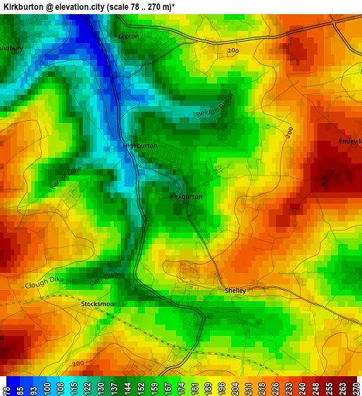
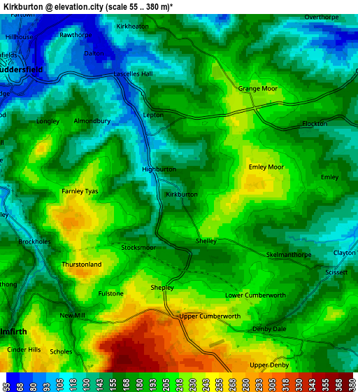
Below is the Elevation map of Kirkburton, which displays elevation range with different colors. Scale of the first map is from 78 to 270 m (256 to 886 ft) with average elevation of 181.4 meters (=595 ft) [note 1]
These maps also provides idea of topography and contour of this city, they are displayed at different zoom levels. More info about maps, scale and edge coordinates you can find below images.
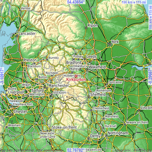
| \ | Map #1 | Map #2 | Topo.Map |
| Scale [m] | 78..270 m | 55..380 m | × |
| Scale [ft] | 256..886 ft | 180..1247 ft | × |
| Average | 181.4 m = 595 ft | 178.3 m = 585 ft | × |
| Width | 5.8 km = 3.6 mi | 11.6 km = 7.2 mi | 185.5 km = 115.3 mi |
| Height | 5.8 km = 3.6 mi | 11.6 km = 7.2 mi | 185.5 km = 115.3 mi |
| ↑Max Latitude | 53.636533° | 53.662581° | 54.43654° |
| Latitude at center | 53.61047° | 53.61047° | 53.61047° |
| ↓Min Latitude | 53.58439° | 53.558295° | 52.76792° |
| ← Min Longitude | -1.746865° | -1.790811° | -3.10917° |
| Longitude center | -1.70292° | -1.70292° | -1.70292° |
| →Max Longitude | -1.658975° | -1.615029° | -0.29667° |
Nearby cities:
Cities around Kirkburton sort by population:
• Huddersfield elevation 90 m
6.9 km,  308°
308°
• Mirfield 47 m
7 km,  3°
3°
• Meltham Mills 171 m
9.2 km,  258°
258°
• Clayton West 127 m
6.3 km,  105°
105°
• Meltham 177 m
9.8 km, 258°
• Shepley 232 m
3.2 km,  196°
196°
• Shelley 217 m
1.7 km,  132°
132°
• Denby Dale 166 m
5.1 km,  145°
145°
• Middlestown 109 m
8.3 km,  57°
57°
• Holmfirth 150 m
7.2 km,  230°
230°
• Emley 192 m
4.7 km,  85°
85°
• Flockton 154 m
4.7 km, 62°
Multilingual:
 En español:
Kirkburton elevación 129 m.
 En France:
Kirkburton élévation 129 m.
 Auf Deutsch:
Kirkburton höhe über dem Meeresspiegel ist 129 m.

Sources and notes:
- [note 1] Map square and city borders are not equal. Map elevation data is calculated only from area inside that square.
- [src 1] Elevation data from geonames database provided with same terms of usage.
- [src 2] The elevation map of Kirkburton is generated using elevation data from NASA's 3 arcsec (90m) resolution SRTM data.
- [src 3] Base (background) map © OpenStreetMap contributors tiles are generated by Geofabrik and OpenTopoMap.
Copyright & License:
This Kirkburton Elevation Map is licensed under CC BY-SA. You may reuse any part from this page, if you give a proper credit by linking to this URL:
 More info on terms of use page.