Knottingley elevation
Knottingley (England, City and Borough of Wakefield), United Kingdom elevation is 28 meters and Knottingley elevation in feet is 92 ft above sea level [src 1]. Knottingley is a populated place (feature code) with elevation that is 44 meters (144 ft) smaller than average city elevation in United Kingdom.
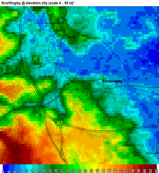
Below is the Elevation map of Knottingley, which displays elevation range with different colors. Scale of the first map is from 4 to 65 m (13 to 213 ft) with average elevation of 24.6 meters (=81 ft) [note 1]
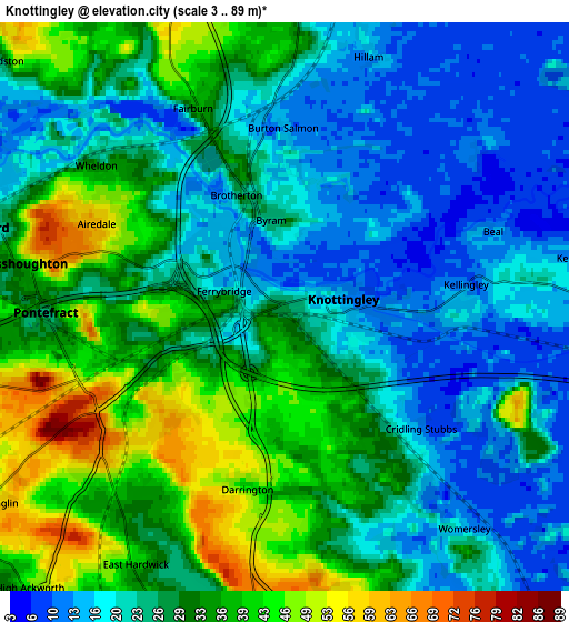
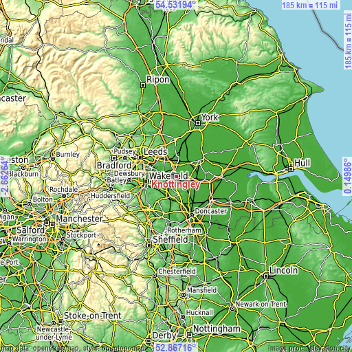
These maps also provides idea of topography and contour of this city, they are displayed at different zoom levels. More info about maps, scale and edge coordinates you can find below images.
| \ | Map #1 | Map #2 | Topo.Map |
| Scale [m] | 4..65 m | 3..89 m | × |
| Scale [ft] | 13..213 ft | 10..292 ft | × |
| Average | 24.6 m = 81 ft | 27.6 m = 91 ft | × |
| Width | 5.78 km = 3.6 mi | 11.57 km = 7.2 mi | 185.1 km = 115 mi |
| Height | 5.78 km = 3.6 mi | 11.57 km = 7.2 mi | 185.1 km = 115 mi |
| ↑Max Latitude | 53.733783° | 53.759771° | 54.53194° |
| Latitude at center | 53.70778° | 53.70778° | 53.70778° |
| ↓Min Latitude | 53.681761° | 53.655725° | 52.86716° |
| ← Min Longitude | -1.300335° | -1.344281° | -2.66264° |
| Longitude center | -1.25639° | -1.25639° | -1.25639° |
| →Max Longitude | -1.212445° | -1.168499° | 0.14986° |
Nearby cities:
Cities around Knottingley sort by population:
• Castleford elevation 15 m
7.3 km,  286°
286°
• Pontefract 69 m
4.1 km,  243°
243°
• Featherstone 48 m
7.4 km, 242°
• South Milford 13 m
7.7 km,  5°
5°
• Hambleton 13 m
8.8 km,  42°
42°
• Monk Fryston 17 m
6.1 km, 11°
• Low Ackworth 28 m
7.8 km,  214°
214°
• Ferrybridge 18 m
1.6 km,  281°
281°
• Byram 26 m
1.8 km,  349°
349°
• Darrington 45 m
3.7 km,  193°
193°
• Ledsham 50 m
7.1 km,  330°
330°
• Ledston 26 m
7.6 km,  310°
310°
Multilingual:
 En español:
Knottingley elevación 28 m.
 En France:
Knottingley élévation 28 m.
 Auf Deutsch:
Knottingley höhe über dem Meeresspiegel ist 28 m.

Sources and notes:
- [note 1] Map square and city borders are not equal. Map elevation data is calculated only from area inside that square.
- [src 1] Elevation data from geonames database provided with same terms of usage.
- [src 2] The elevation map of Knottingley is generated using elevation data from NASA's 3 arcsec (90m) resolution SRTM data.
- [src 3] Base (background) map © OpenStreetMap contributors tiles are generated by Geofabrik and OpenTopoMap.
Copyright & License:
This Knottingley Elevation Map is licensed under CC BY-SA. You may reuse any part from this page, if you give a proper credit by linking to this URL:
 More info on terms of use page.