Llangain elevation
Llangain (Wales, Carmarthenshire), United Kingdom elevation is 97 meters and Llangain elevation in feet is 318 ft above sea level [src 1]. Llangain is a seat of a third-order administrative division (feature code) with elevation that is 25 meters (82 ft) bigger than average city elevation in United Kingdom.
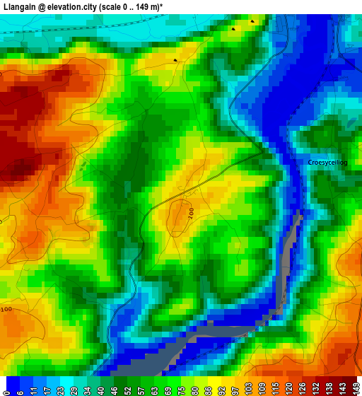
Below is the Elevation map of Llangain, which displays elevation range with different colors. Scale of the first map is from 0 to 149 m (0 to 489 ft) with average elevation of 63.3 meters (=208 ft) [note 1]
These maps also provides idea of topography and contour of this city, they are displayed at different zoom levels. More info about maps, scale and edge coordinates you can find below images.
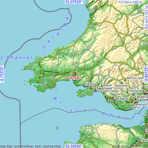
| \ | Map #1 | Topo.Map |
| Scale [m] | 0..149 m | × |
| Scale [ft] | 0..489 ft | × |
| Average | 63.3 m = 208 ft | × |
| Width | 6.04 km = 3.8 mi | 193.3 km = 120.1 mi |
| Height | 6.04 km = 3.8 mi | 193.3 km = 120.1 mi |
| ↑Max Latitude | 51.845487° | 52.67925° |
| Latitude at center | 51.81833° | 51.81833° |
| ↓Min Latitude | 51.791157° | 50.94064° |
| ← Min Longitude | -4.391445° | -5.75375° |
| Longitude center | -4.3475° | -4.3475° |
| →Max Longitude | -4.303555° | -2.94125° |
Nearby cities:
Cities around Llangain sort by population:
• Carmarthen elevation 23 m
5 km,  35°
35°
• Kidwelly 16 m
9.6 km,  161°
161°
• Pontyberem 50 m
13.1 km,  109°
109°
• Saint Clears 7 m
10.3 km,  270°
270°
• Trimsaran 56 m
13.1 km,  146°
146°
• Pontyates 15 m
11.6 km,  129°
129°
• Llansteffan 32 m
5.9 km,  210°
210°
• Llanwinio 184 m
16.1 km,  308°
308°
• Llanddowror 9 m
12.8 km,  261°
261°
• Llanddarog 114 m
11.9 km,  85°
85°
• Abernant 84 m
8.4 km,  326°
326°
• Llangynog 114 m
4.3 km, 274°
Multilingual:
 En español:
Llangain elevación 97 m.
 En France:
Llangain élévation 97 m.


Sources and notes:
- [note 1] Map square and city borders are not equal. Map elevation data is calculated only from area inside that square.
- [src 1] Elevation data from geonames database provided with same terms of usage.
- [src 2] The elevation map of Llangain is generated using elevation data from NASA's 3 arcsec (90m) resolution SRTM data.
- [src 3] Base (background) map © OpenStreetMap contributors tiles are generated by Geofabrik and OpenTopoMap.
Copyright & License:
This Llangain Elevation Map is licensed under CC BY-SA. You may reuse any part from this page, if you give a proper credit by linking to this URL:
 More info on terms of use page.