Ludlow elevation
Ludlow (England, Shropshire), United Kingdom elevation is 117 meters and Ludlow elevation in feet is 384 ft above sea level [src 1]. Ludlow is a populated place (feature code) with elevation that is 45 meters (148 ft) bigger than average city elevation in United Kingdom.
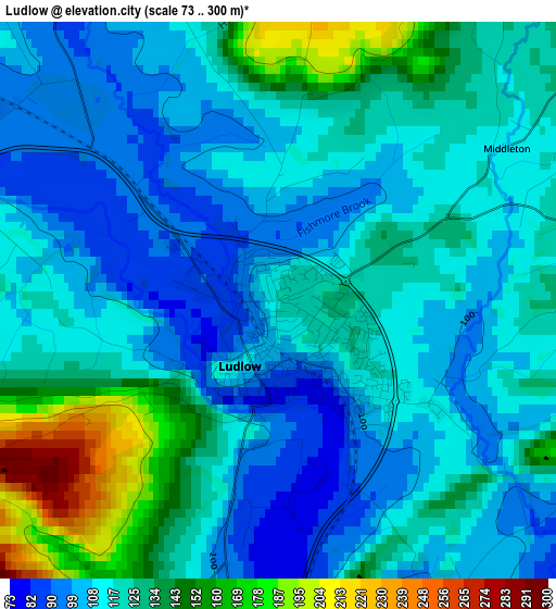
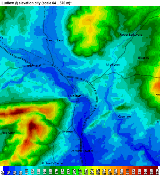
Below is the Elevation map of Ludlow, which displays elevation range with different colors. Scale of the first map is from 73 to 300 m (240 to 984 ft) with average elevation of 120.5 meters (=395 ft) [note 1]
These maps also provides idea of topography and contour of this city, they are displayed at different zoom levels. More info about maps, scale and edge coordinates you can find below images.
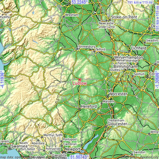
| \ | Map #1 | Map #2 | Topo.Map |
| Scale [m] | 73..300 m | 64..370 m | × |
| Scale [ft] | 240..984 ft | 210..1214 ft | × |
| Average | 120.5 m = 395 ft | 141.9 m = 466 ft | × |
| Width | 5.97 km = 3.7 mi | 11.93 km = 7.4 mi | 190.9 km = 118.6 mi |
| Height | 5.97 km = 3.7 mi | 11.93 km = 7.4 mi | 190.9 km = 118.6 mi |
| ↑Max Latitude | 52.40113° | 52.427935° | 53.2245° |
| Latitude at center | 52.37431° | 52.37431° | 52.37431° |
| ↓Min Latitude | 52.347473° | 52.32062° | 51.50743° |
| ← Min Longitude | -2.757055° | -2.801001° | -4.11936° |
| Longitude center | -2.71311° | -2.71311° | -2.71311° |
| →Max Longitude | -2.669165° | -2.625219° | -1.30686° |
Nearby cities:
Cities around Ludlow sort by population:
• Tenbury Wells elevation 56 m
10.6 km,  131°
131°
• Cleobury Mortimer 133 m
15.7 km,  88°
88°
• Craven Arms 123 m
11.3 km,  312°
312°
• Wigmore 133 m
11.9 km,  236°
236°
• Orleton 92 m
8.6 km,  196°
196°
• Kingsland 89 m
15.6 km,  206°
206°
• Eyton 100 m
14 km,  190°
190°
• Kimbolton 101 m
13.9 km,  176°
176°
• Downton 211 m
8.2 km,  264°
264°
• Burrington 163 m
7.5 km,  248°
248°
• Elton 142 m
7.5 km,  232°
232°
• Bromfield 99 m
3.8 km,  285°
285°
Multilingual:
 En español:
Ludlow elevación 117 m.
 En France:
Ludlow élévation 117 m.


Sources and notes:
- [note 1] Map square and city borders are not equal. Map elevation data is calculated only from area inside that square.
- [src 1] Elevation data from geonames database provided with same terms of usage.
- [src 2] The elevation map of Ludlow is generated using elevation data from NASA's 3 arcsec (90m) resolution SRTM data.
- [src 3] Base (background) map © OpenStreetMap contributors tiles are generated by Geofabrik and OpenTopoMap.
Copyright & License:
This Ludlow Elevation Map is licensed under CC BY-SA. You may reuse any part from this page, if you give a proper credit by linking to this URL:
 More info on terms of use page.