Maghera elevation
Maghera (Northern Ireland, Mid Ulster), United Kingdom elevation is 74 meters and Maghera elevation in feet is 243 ft above sea level [src 1]. Maghera is a populated place (feature code) with elevation that is 2 meters (7 ft) bigger than average city elevation in United Kingdom.
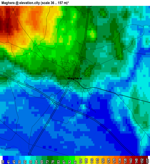
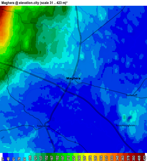
Below is the Elevation map of Maghera, which displays elevation range with different colors. Scale of the first map is from 36 to 157 m (118 to 515 ft) with average elevation of 65.5 meters (=215 ft) [note 1]
These maps also provides idea of topography and contour of this city, they are displayed at different zoom levels. More info about maps, scale and edge coordinates you can find below images.
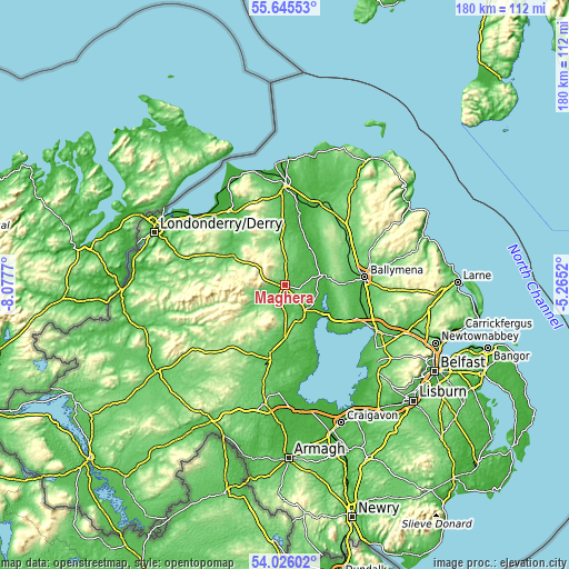
| \ | Map #1 | Map #2 | Topo.Map |
| Scale [m] | 36..157 m | 31..423 m | × |
| Scale [ft] | 118..515 ft | 102..1388 ft | × |
| Average | 65.5 m = 215 ft | 79.9 m = 262 ft | × |
| Width | 5.63 km = 3.5 mi | 11.25 km = 7 mi | 180.1 km = 111.9 mi |
| Height | 5.63 km = 3.5 mi | 11.25 km = 7 mi | 180.1 km = 111.9 mi |
| ↑Max Latitude | 54.869196° | 54.894476° | 55.64553° |
| Latitude at center | 54.8439° | 54.8439° | 54.8439° |
| ↓Min Latitude | 54.818588° | 54.79326° | 54.02602° |
| ← Min Longitude | -6.715395° | -6.759341° | -8.0777° |
| Longitude center | -6.67145° | -6.67145° | -6.67145° |
| →Max Longitude | -6.627505° | -6.583559° | -5.2652° |
Nearby cities:
Cities around Maghera sort by population:
• Cookstown elevation 78 m
22.8 km,  192°
192°
• Magherafelt 76 m
10.9 km,  157°
157°
• Ahoghill 85 m
19.7 km,  82°
82°
• Dungiven 75 m
18.6 km,  302°
302°
• Cullybackey 72 m
21.4 km, 76°
• Castledawson 33 m
10.2 km,  136°
136°
• Draperstown 73 m
7.8 km,  231°
231°
• Kilrea 49 m
14 km,  31°
31°
• Moneymore 48 m
16.9 km,  179°
179°
• Garvagh 66 m
15.5 km,  1°
1°
• Portglenone 32 m
13.2 km, 76°
• Bellaghy 26 m
10.5 km,  111°
111°
Multilingual:
 En español:
Maghera elevación 74 m.
 En France:
Maghera élévation 74 m.


Sources and notes:
- [note 1] Map square and city borders are not equal. Map elevation data is calculated only from area inside that square.
- [src 1] Elevation data from geonames database provided with same terms of usage.
- [src 2] The elevation map of Maghera is generated using elevation data from NASA's 3 arcsec (90m) resolution SRTM data.
- [src 3] Base (background) map © OpenStreetMap contributors tiles are generated by Geofabrik and OpenTopoMap.
Copyright & License:
This Maghera Elevation Map is licensed under CC BY-SA. You may reuse any part from this page, if you give a proper credit by linking to this URL:
 More info on terms of use page.