Newport Pagnell elevation
Newport Pagnell (England, Milton Keynes), United Kingdom elevation is 63 meters and Newport Pagnell elevation in feet is 207 ft above sea level [src 1]. Newport Pagnell is a seat of a third-order administrative division (feature code) with elevation that is 9 meters (30 ft) smaller than average city elevation in United Kingdom.
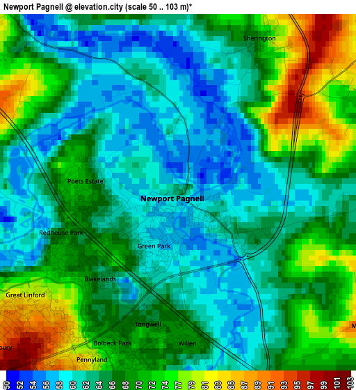
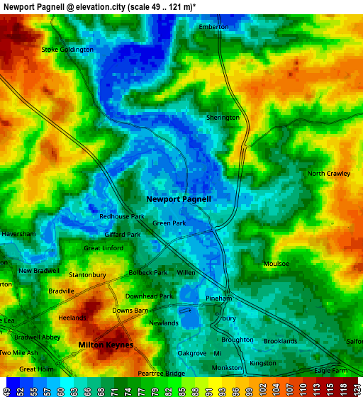
Below is the Elevation map of Newport Pagnell, which displays elevation range with different colors. Scale of the first map is from 50 to 103 m (164 to 338 ft) with average elevation of 67.2 meters (=220 ft) [note 1]
These maps also provides idea of topography and contour of this city, they are displayed at different zoom levels. More info about maps, scale and edge coordinates you can find below images.
| \ | Map #1 | Map #2 | Topo.Map |
| Scale [m] | 50..103 m | 49..121 m | × |
| Scale [ft] | 164..338 ft | 161..397 ft | × |
| Average | 67.2 m = 220 ft | 77.8 m = 255 ft | × |
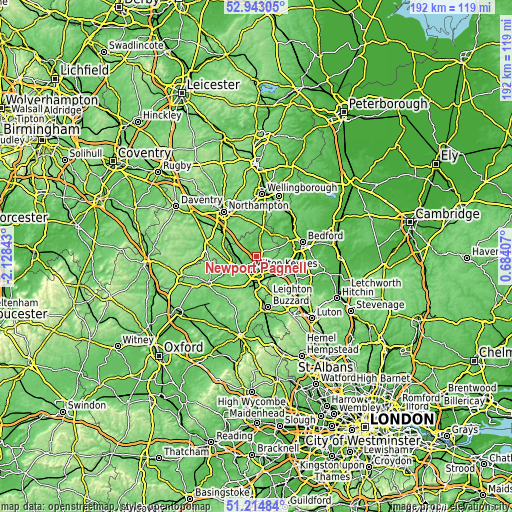
| Width | 6 km = 3.7 mi | 12.01 km = 7.5 mi | 192.2 km = 119.4 mi |
| Height | 6 km = 3.7 mi | 12.01 km = 7.5 mi | 192.1 km = 119.4 mi |
| ↑Max Latitude | 52.114304° | 52.141283° | 52.94305° |
| Latitude at center | 52.08731° | 52.08731° | 52.08731° |
| ↓Min Latitude | 52.060299° | 52.033272° | 51.21484° |
| ← Min Longitude | -0.766125° | -0.810071° | -2.12843° |
| Longitude center | -0.72218° | -0.72218° | -0.72218° |
| →Max Longitude | -0.678235° | -0.634289° | 0.68407° |
Nearby cities:
Cities around Newport Pagnell sort by population:
• Milton Keynes elevation 114 m
5.6 km,  204°
204°
• Sherington 76 m
3.1 km,  29°
29°
• Stoke Goldington 68 m
6.2 km,  322°
322°
• Emberton 66 m
5.6 km,  10°
10°
• Ravenstone 88 m
7.3 km,  340°
340°
• Weston Underwood 76 m
6.6 km,  350°
350°
• Bradwell 80 m
6.2 km,  226°
226°
• Broughton 66 m
4.5 km,  154°
154°
• Gayhurst 70 m
4 km, 316°
• Moulsoe 81 m
3.9 km,  121°
121°
• Chicheley 82 m
3 km,  54°
54°
• Lathbury 59 m
1.3 km,  2°
2°
Multilingual:
 En español:
Newport Pagnell elevación 63 m.
 En France:
Newport Pagnell élévation 63 m.
 Auf Deutsch:
Newport Pagnell höhe über dem Meeresspiegel ist 63 m.

Sources and notes:
- [note 1] Map square and city borders are not equal. Map elevation data is calculated only from area inside that square.
- [src 1] Elevation data from geonames database provided with same terms of usage.
- [src 2] The elevation map of Newport Pagnell is generated using elevation data from NASA's 3 arcsec (90m) resolution SRTM data.
- [src 3] Base (background) map © OpenStreetMap contributors tiles are generated by Geofabrik and OpenTopoMap.
Copyright & License:
This Newport Pagnell Elevation Map is licensed under CC BY-SA. You may reuse any part from this page, if you give a proper credit by linking to this URL:
 More info on terms of use page.