Scone elevation
Scone (Scotland, Perth and Kinross), United Kingdom elevation is 52 meters and Scone elevation in feet is 171 ft above sea level [src 1]. Scone is a populated place (feature code) with elevation that is 20 meters (66 ft) smaller than average city elevation in United Kingdom.
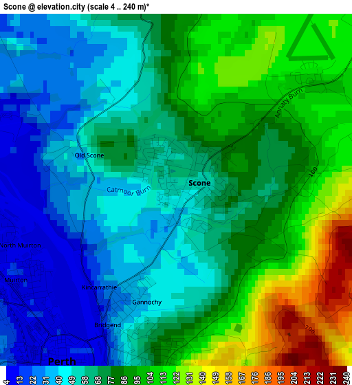
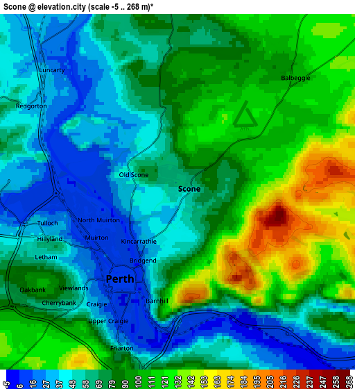
Below is the Elevation map of Scone, which displays elevation range with different colors. Scale of the first map is from 4 to 240 m (13 to 787 ft) with average elevation of 73.5 meters (=241 ft) [note 1]
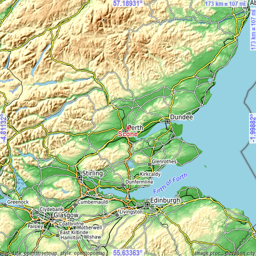
These maps also provides idea of topography and contour of this city, they are displayed at different zoom levels. More info about maps, scale and edge coordinates you can find below images.
| \ | Map #1 | Map #2 | Topo.Map |
| Scale [m] | 4..240 m | -5..268 m | × |
| Scale [ft] | 13..787 ft | -16..879 ft | × |
| Average | 73.5 m = 241 ft | 77.8 m = 255 ft | × |
| Width | 5.41 km = 3.4 mi | 10.81 km = 6.7 mi | 173 km = 107.5 mi |
| Height | 5.41 km = 3.4 mi | 10.81 km = 6.7 mi | 173 km = 107.5 mi |
| ↑Max Latitude | 56.443719° | 56.468002° | 57.18931° |
| Latitude at center | 56.41942° | 56.41942° | 56.41942° |
| ↓Min Latitude | 56.395106° | 56.370776° | 55.63363° |
| ← Min Longitude | -3.449015° | -3.492961° | -4.81132° |
| Longitude center | -3.40507° | -3.40507° | -3.40507° |
| →Max Longitude | -3.361125° | -3.317179° | -1.99882° |
Nearby cities:
Cities around Scone sort by population:
• Perth elevation 10 m
3.1 km,  211°
211°
• Bridge of Earn 11 m
7.9 km,  180°
180°
• Coupar Angus 57 m
16.4 km,  31°
31°
• Newburgh 21 m
12.9 km,  126°
126°
• Luncarty 27 m
5.5 km,  313°
313°
• Abernethy 36 m
11.2 km,  149°
149°
• Stanley 66 m
7.9 km,  338°
338°
• Almondbank 35 m
6.9 km,  268°
268°
• Errol 34 m
12.2 km,  104°
104°
• Bankfoot 71 m
11.3 km,  322°
322°
• Inchture 18 m
14.8 km,  78°
78°
• Methven 77 m
10.7 km, 268°
Multilingual:
 En español:
Scone elevación 52 m.
 En France:
Scone élévation 52 m.


Sources and notes:
- [note 1] Map square and city borders are not equal. Map elevation data is calculated only from area inside that square.
- [src 1] Elevation data from geonames database provided with same terms of usage.
- [src 2] The elevation map of Scone is generated using elevation data from NASA's 3 arcsec (90m) resolution SRTM data.
- [src 3] Base (background) map © OpenStreetMap contributors tiles are generated by Geofabrik and OpenTopoMap.
Copyright & License:
This Scone Elevation Map is licensed under CC BY-SA. You may reuse any part from this page, if you give a proper credit by linking to this URL:
 More info on terms of use page.