Norton elevation
Norton (England, North Yorkshire), United Kingdom elevation is 20 meters and Norton elevation in feet is 66 ft above sea level [src 1]. Norton is a populated place (feature code) with elevation that is 52 meters (171 ft) smaller than average city elevation in United Kingdom.
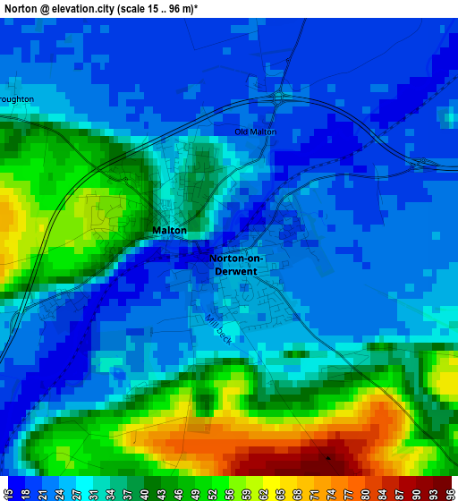
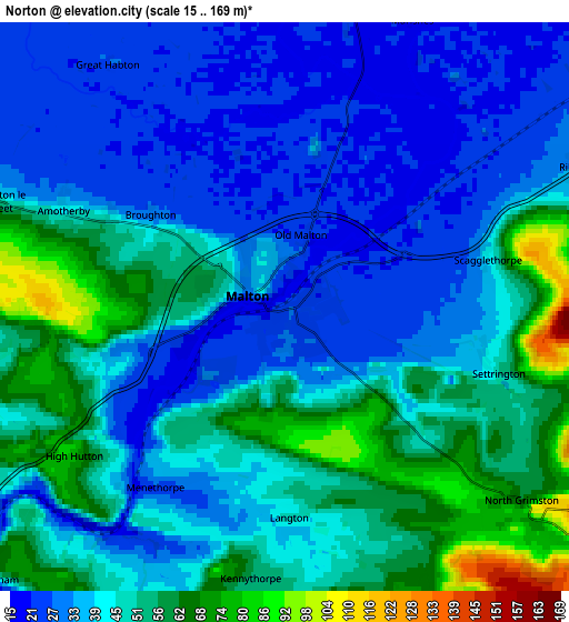
Below is the Elevation map of Norton, which displays elevation range with different colors. Scale of the first map is from 15 to 96 m (49 to 315 ft) with average elevation of 33.5 meters (=110 ft) [note 1]
These maps also provides idea of topography and contour of this city, they are displayed at different zoom levels. More info about maps, scale and edge coordinates you can find below images.
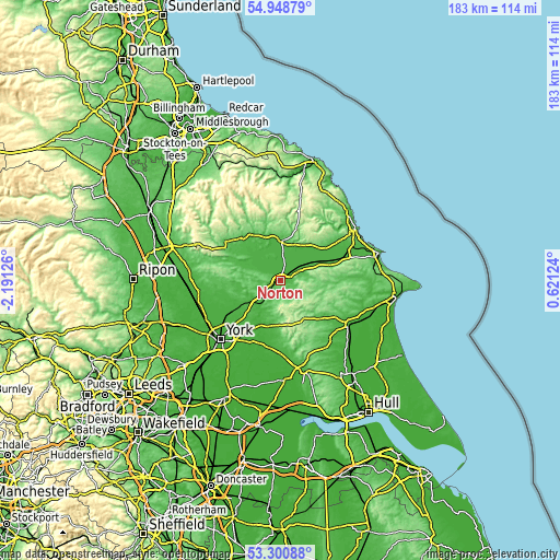
| \ | Map #1 | Map #2 | Topo.Map |
| Scale [m] | 15..96 m | 15..169 m | × |
| Scale [ft] | 49..315 ft | 49..554 ft | × |
| Average | 33.5 m = 110 ft | 42.6 m = 140 ft | × |
| Width | 5.73 km = 3.6 mi | 11.45 km = 7.1 mi | 183.2 km = 113.8 mi |
| Height | 5.73 km = 3.6 mi | 11.45 km = 7.1 mi | 183.2 km = 113.8 mi |
| ↑Max Latitude | 54.15877° | 54.184494° | 54.94879° |
| Latitude at center | 54.13303° | 54.13303° | 54.13303° |
| ↓Min Latitude | 54.107274° | 54.081502° | 53.30088° |
| ← Min Longitude | -0.828955° | -0.872901° | -2.19126° |
| Longitude center | -0.78501° | -0.78501° | -0.78501° |
| →Max Longitude | -0.741065° | -0.697119° | 0.62124° |
Nearby cities:
Cities around Norton sort by population:
• Pickering elevation 62 m
13.1 km,  5°
5°
• Malton 37 m
1 km,  294°
294°
• Stamford Bridge 21 m
18.2 km,  207°
207°
• Kirkbymoorside 67 m
18 km,  327°
327°
• Thornton Dale 37 m
12.1 km,  20°
20°
• Rillington 34 m
6.5 km,  64°
64°
• Full Sutton 19 m
16.9 km,  198°
198°
• Sheriff Hutton 66 m
15.2 km,  251°
251°
• Wetwang 66 m
18.7 km,  133°
133°
• Fimber 96 m
14.8 km,  137°
137°
• Bugthorpe 49 m
13.8 km,  190°
190°
• Kirby Underdale 110 m
12.9 km,  175°
175°
Multilingual:
 En español:
Norton elevación 20 m.
 En France:
Norton élévation 20 m.


Sources and notes:
- [note 1] Map square and city borders are not equal. Map elevation data is calculated only from area inside that square.
- [src 1] Elevation data from geonames database provided with same terms of usage.
- [src 2] The elevation map of Norton is generated using elevation data from NASA's 3 arcsec (90m) resolution SRTM data.
- [src 3] Base (background) map © OpenStreetMap contributors tiles are generated by Geofabrik and OpenTopoMap.
Copyright & License:
This Norton Elevation Map is licensed under CC BY-SA. You may reuse any part from this page, if you give a proper credit by linking to this URL:
 More info on terms of use page.