Otford elevation
Otford (England, Kent), United Kingdom elevation is 70 meters and Otford elevation in feet is 230 ft above sea level [src 1]. Otford is a populated place (feature code) with elevation that is 2 meters (7 ft) smaller than average city elevation in United Kingdom.
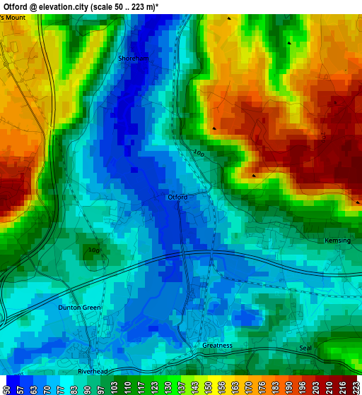
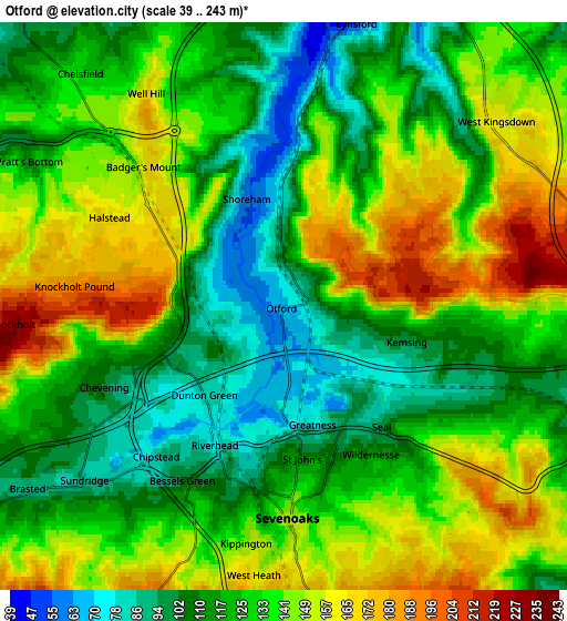
Below is the Elevation map of Otford, which displays elevation range with different colors. Scale of the first map is from 50 to 223 m (164 to 732 ft) with average elevation of 111.1 meters (=365 ft) [note 1]
These maps also provides idea of topography and contour of this city, they are displayed at different zoom levels. More info about maps, scale and edge coordinates you can find below images.
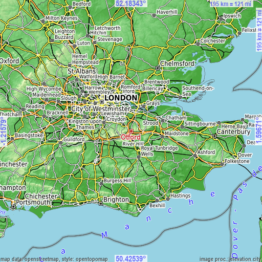
| \ | Map #1 | Map #2 | Topo.Map |
| Scale [m] | 50..223 m | 39..243 m | × |
| Scale [ft] | 164..732 ft | 128..797 ft | × |
| Average | 111.1 m = 365 ft | 130.7 m = 429 ft | × |
| Width | 6.11 km = 3.8 mi | 12.22 km = 7.6 mi | 195.5 km = 121.5 mi |
| Height | 6.11 km = 3.8 mi | 12.22 km = 7.6 mi | 195.5 km = 121.5 mi |
| ↑Max Latitude | 51.340291° | 51.367735° | 52.18343° |
| Latitude at center | 51.31283° | 51.31283° | 51.31283° |
| ↓Min Latitude | 51.285353° | 51.257859° | 50.42539° |
| ← Min Longitude | 0.146515° | 0.102569° | -1.21579° |
| Longitude center | 0.19046° | 0.19046° | 0.19046° |
| →Max Longitude | 0.234405° | 0.278351° | 1.59671° |
Nearby cities:
Cities around Otford sort by population:
• Sevenoaks elevation 144 m
4.5 km,  181°
181°
• Swanley 81 m
9.5 km,  352°
352°
• Orpington 62 m
9.4 km,  316°
316°
• Farnborough 110 m
9.9 km,  301°
301°
• Kemsing 98 m
2.8 km,  105°
105°
• West Kingsdown 163 m
5.9 km,  55°
55°
• Borough Green 92 m
8.3 km, 106°
• Westerham 116 m
9.9 km,  238°
238°
• Eynsford 43 m
6.3 km,  13°
13°
• Wrotham 130 m
8.3 km,  93°
93°
• Sundridge 84 m
6.1 km,  230°
230°
• Horton Kirby 32 m
9.9 km,  22°
22°
Multilingual:
 En español:
Otford elevación 70 m.
 En France:
Otford élévation 70 m.


Sources and notes:
- [note 1] Map square and city borders are not equal. Map elevation data is calculated only from area inside that square.
- [src 1] Elevation data from geonames database provided with same terms of usage.
- [src 2] The elevation map of Otford is generated using elevation data from NASA's 3 arcsec (90m) resolution SRTM data.
- [src 3] Base (background) map © OpenStreetMap contributors tiles are generated by Geofabrik and OpenTopoMap.
Copyright & License:
This Otford Elevation Map is licensed under CC BY-SA. You may reuse any part from this page, if you give a proper credit by linking to this URL:
 More info on terms of use page.