Ponteland elevation
Ponteland (England, Northumberland), United Kingdom elevation is 63 meters and Ponteland elevation in feet is 207 ft above sea level [src 1]. Ponteland is a populated place (feature code) with elevation that is 9 meters (30 ft) smaller than average city elevation in United Kingdom.
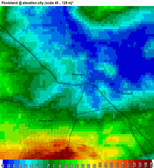
Below is the Elevation map of Ponteland, which displays elevation range with different colors. Scale of the first map is from 49 to 129 m (161 to 423 ft) with average elevation of 72 meters (=236 ft) [note 1]
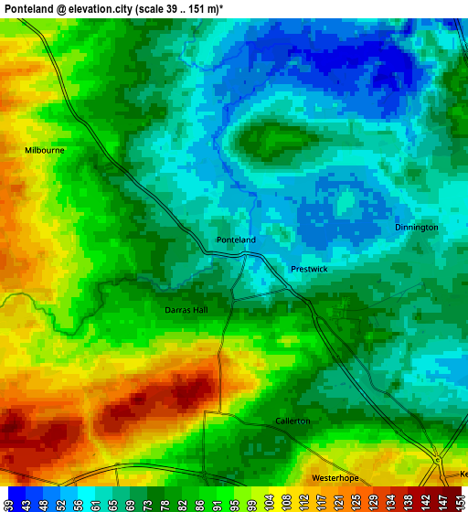
These maps also provides idea of topography and contour of this city, they are displayed at different zoom levels. More info about maps, scale and edge coordinates you can find below images.
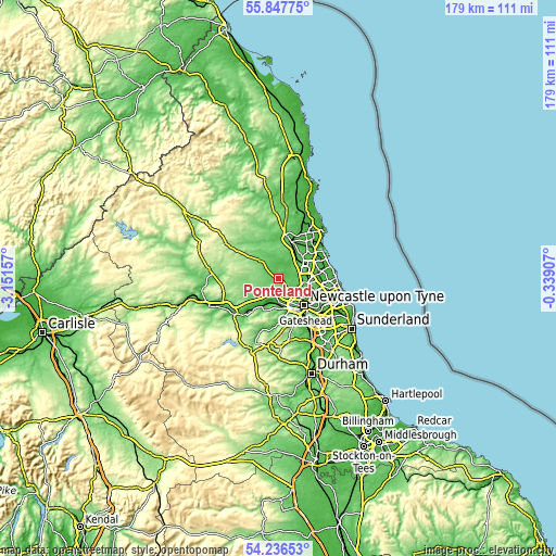
| \ | Map #1 | Map #2 | Topo.Map |
| Scale [m] | 49..129 m | 39..151 m | × |
| Scale [ft] | 161..423 ft | 128..495 ft | × |
| Average | 72 m = 236 ft | 80.8 m = 265 ft | × |
| Width | 5.6 km = 3.5 mi | 11.2 km = 7 mi | 179.2 km = 111.3 mi |
| Height | 5.6 km = 3.5 mi | 11.2 km = 7 mi | 179.1 km = 111.3 mi |
| ↑Max Latitude | 55.075407° | 55.100557° | 55.84775° |
| Latitude at center | 55.05024° | 55.05024° | 55.05024° |
| ↓Min Latitude | 55.025058° | 54.999859° | 54.23653° |
| ← Min Longitude | -1.789265° | -1.833211° | -3.15157° |
| Longitude center | -1.74532° | -1.74532° | -1.74532° |
| →Max Longitude | -1.701375° | -1.657429° | -0.33907° |
Nearby cities:
Cities around Ponteland sort by population:
• Newburn elevation 40 m
7 km,  179°
179°
• Gosforth 67 m
9.9 km,  124°
124°
• Darras Hall 82 m
2 km,  216°
216°
• Blaydon-on-Tyne 10 m
9.7 km,  168°
168°
• Wideopen 69 m
7.8 km,  94°
94°
• Benwell 93 m
9.9 km,  150°
150°
• Dinnington 68 m
4.5 km,  84°
84°
• Wylam 26 m
9.5 km,  210°
210°
• Heddon on the Wall 132 m
6.7 km, 207°
• Hazlerigg 70 m
6.8 km,  98°
98°
• Stannington 63 m
8.1 km,  36°
36°
• Meldon 118 m
9.9 km,  339°
339°
Multilingual:
 En español:
Ponteland elevación 63 m.
 En France:
Ponteland élévation 63 m.
 Auf Deutsch:
Ponteland höhe über dem Meeresspiegel ist 63 m.

Sources and notes:
- [note 1] Map square and city borders are not equal. Map elevation data is calculated only from area inside that square.
- [src 1] Elevation data from geonames database provided with same terms of usage.
- [src 2] The elevation map of Ponteland is generated using elevation data from NASA's 3 arcsec (90m) resolution SRTM data.
- [src 3] Base (background) map © OpenStreetMap contributors tiles are generated by Geofabrik and OpenTopoMap.
Copyright & License:
This Ponteland Elevation Map is licensed under CC BY-SA. You may reuse any part from this page, if you give a proper credit by linking to this URL:
 More info on terms of use page.