Portstewart elevation
Portstewart (Northern Ireland, Causeway Coast and Glens), United Kingdom elevation is 26 meters and Portstewart elevation in feet is 85 ft above sea level [src 1]. Portstewart is a populated place (feature code) with elevation that is 46 meters (151 ft) smaller than average city elevation in United Kingdom.
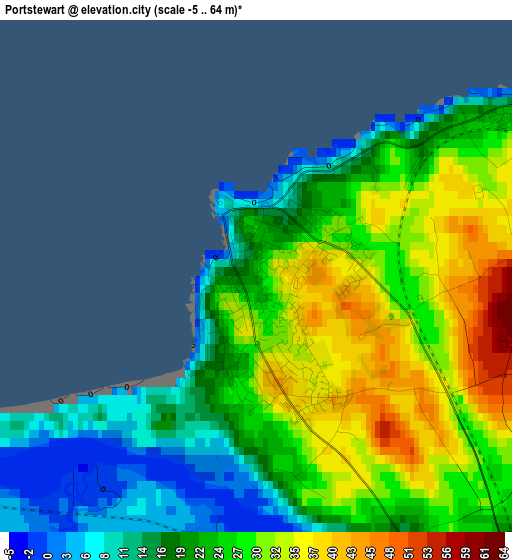
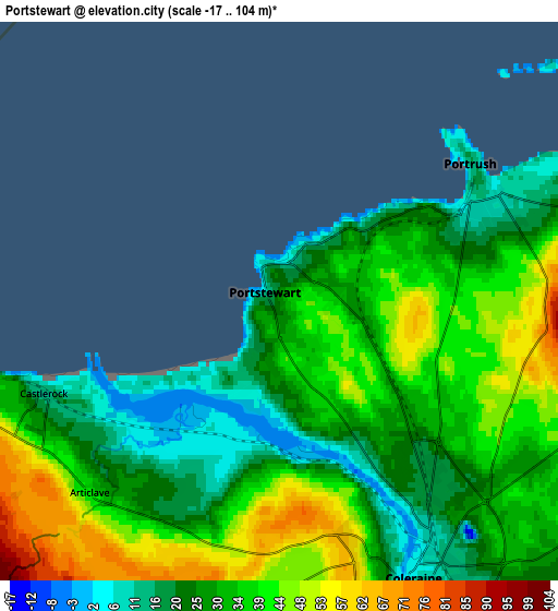
Below is the Elevation map of Portstewart, which displays elevation range with different colors. Scale of the first map is from -5 to 64 m (-16 to 210 ft) with average elevation of 24.8 meters (=81 ft) [note 1]
These maps also provides idea of topography and contour of this city, they are displayed at different zoom levels. More info about maps, scale and edge coordinates you can find below images.
| \ | Map #1 | Map #2 | Topo.Map |
| Scale [m] | -5..64 m | -17..104 m | × |
| Scale [ft] | -16..210 ft | -56..341 ft | × |
| Average | 24.8 m = 81 ft | 33 m = 108 ft | × |
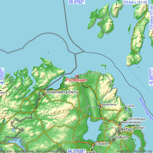
| Width | 5.58 km = 3.5 mi | 11.16 km = 6.9 mi | 178.6 km = 111 mi |
| Height | 5.58 km = 3.5 mi | 11.16 km = 6.9 mi | 178.5 km = 110.9 mi |
| ↑Max Latitude | 55.206404° | 55.231472° | 55.9762° |
| Latitude at center | 55.18132° | 55.18132° | 55.18132° |
| ↓Min Latitude | 55.15622° | 55.131104° | 54.37026° |
| ← Min Longitude | -6.757965° | -6.801911° | -8.12027° |
| Longitude center | -6.71402° | -6.71402° | -6.71402° |
| →Max Longitude | -6.670075° | -6.626129° | -5.30777° |
Nearby cities:
Cities around Portstewart sort by population:
• Coleraine elevation 5 m
6.1 km,  150°
150°
• Limavady 20 m
20.9 km,  225°
225°
• Ballymoney 43 m
17.9 km,  133°
133°
• Portrush 11 m
4.4 km,  68°
68°
• Ballycastle 11 m
30 km,  85°
85°
• Ballintoy Harbour 4 m
23 km, 72°
• Ballykelly 22 m
24.6 km, 231°
• Kilrea 49 m
27.5 km,  158°
158°
• Castlerock 54 m
5.6 km, 231°
• Garvagh 66 m
22.2 km,  172°
172°
• Bushmills 12 m
12.6 km,  78°
78°
• Dunloy 114 m
27 km, 134°
Multilingual:
 En español:
Portstewart elevación 26 m.
 En France:
Portstewart élévation 26 m.
 Auf Deutsch:
Portstewart höhe über dem Meeresspiegel ist 26 m.

Sources and notes:
- [note 1] Map square and city borders are not equal. Map elevation data is calculated only from area inside that square.
- [src 1] Elevation data from geonames database provided with same terms of usage.
- [src 2] The elevation map of Portstewart is generated using elevation data from NASA's 3 arcsec (90m) resolution SRTM data.
- [src 3] Base (background) map © OpenStreetMap contributors tiles are generated by Geofabrik and OpenTopoMap.
Copyright & License:
This Portstewart Elevation Map is licensed under CC BY-SA. You may reuse any part from this page, if you give a proper credit by linking to this URL:
 More info on terms of use page.