Redhill elevation
Redhill (England, Surrey), United Kingdom elevation is 89 meters and Redhill elevation in feet is 292 ft above sea level [src 1]. Redhill is a populated place (feature code) with elevation that is 17 meters (56 ft) bigger than average city elevation in United Kingdom.
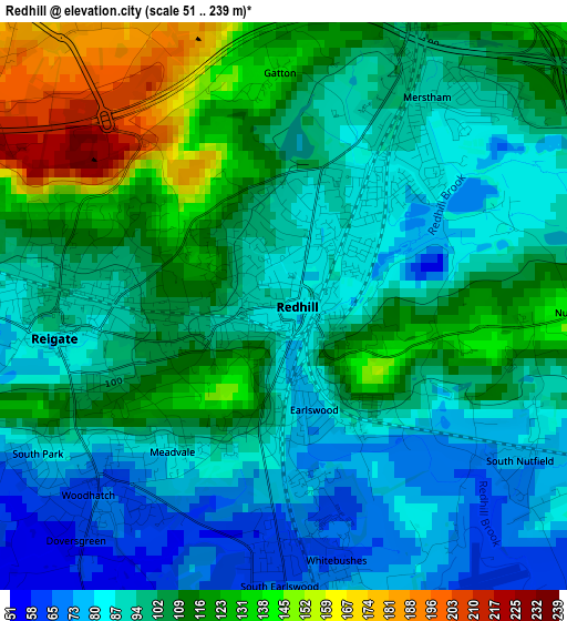
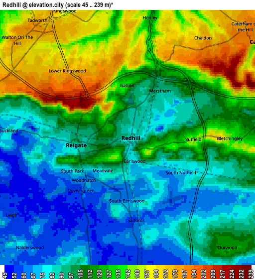
Below is the Elevation map of Redhill, which displays elevation range with different colors. Scale of the first map is from 51 to 239 m (167 to 784 ft) with average elevation of 102.7 meters (=337 ft) [note 1]
These maps also provides idea of topography and contour of this city, they are displayed at different zoom levels. More info about maps, scale and edge coordinates you can find below images.
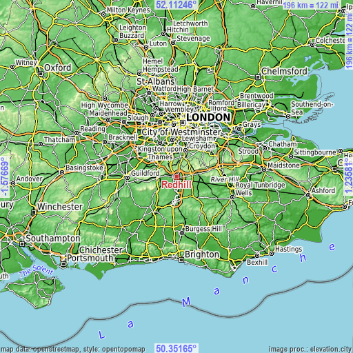
| \ | Map #1 | Map #2 | Topo.Map |
| Scale [m] | 51..239 m | 45..239 m | × |
| Scale [ft] | 167..784 ft | 148..784 ft | × |
| Average | 102.7 m = 337 ft | 110.9 m = 364 ft | × |
| Width | 6.12 km = 3.8 mi | 12.24 km = 7.6 mi | 195.8 km = 121.7 mi |
| Height | 6.12 km = 3.8 mi | 12.24 km = 7.6 mi | 195.8 km = 121.7 mi |
| ↑Max Latitude | 51.267984° | 51.295471° | 52.11246° |
| Latitude at center | 51.24048° | 51.24048° | 51.24048° |
| ↓Min Latitude | 51.21296° | 51.185423° | 50.35165° |
| ← Min Longitude | -0.214385° | -0.258331° | -1.57669° |
| Longitude center | -0.17044° | -0.17044° | -0.17044° |
| →Max Longitude | -0.126495° | -0.082549° | 1.23581° |
Nearby cities:
Cities around Redhill sort by population:
• Reigate elevation 85 m
2.5 km,  261°
261°
• Banstead 160 m
9.4 km,  344°
344°
• Coulsdon 82 m
9.1 km,  13°
13°
• Horley 56 m
7.4 km,  173°
173°
• Caterham 140 m
7.9 km,  53°
53°
• Tadworth 171 m
7.3 km,  321°
321°
• Salfords 55 m
4 km,  179°
179°
• Whyteleafe 113 m
9.6 km,  38°
38°
• Godstone 104 m
7.1 km,  83°
83°
• Bletchingley 143 m
4.9 km,  89°
89°
• Lower Kingswood 178 m
4.4 km, 318°
• Blindley Heath 57 m
9.8 km,  122°
122°
Multilingual:
 En español:
Redhill elevación 89 m.
 En France:
Redhill élévation 89 m.


Sources and notes:
- [note 1] Map square and city borders are not equal. Map elevation data is calculated only from area inside that square.
- [src 1] Elevation data from geonames database provided with same terms of usage.
- [src 2] The elevation map of Redhill is generated using elevation data from NASA's 3 arcsec (90m) resolution SRTM data.
- [src 3] Base (background) map © OpenStreetMap contributors tiles are generated by Geofabrik and OpenTopoMap.
Copyright & License:
This Redhill Elevation Map is licensed under CC BY-SA. You may reuse any part from this page, if you give a proper credit by linking to this URL:
 More info on terms of use page.