Shildon elevation
Shildon (England, County Durham), United Kingdom elevation is 132 meters and Shildon elevation in feet is 433 ft above sea level [src 1]. Shildon is a populated place (feature code) with elevation that is 60 meters (197 ft) bigger than average city elevation in United Kingdom.
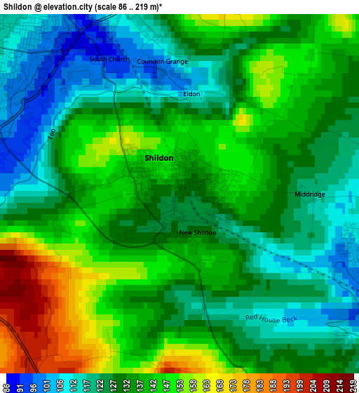
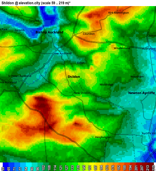
Below is the Elevation map of Shildon, which displays elevation range with different colors. Scale of the first map is from 86 to 219 m (282 to 719 ft) with average elevation of 134.1 meters (=440 ft) [note 1]
These maps also provides idea of topography and contour of this city, they are displayed at different zoom levels. More info about maps, scale and edge coordinates you can find below images.
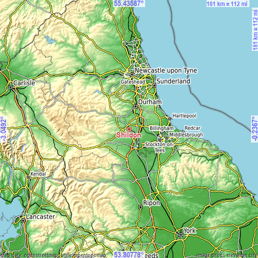
| \ | Map #1 | Map #2 | Topo.Map |
| Scale [m] | 86..219 m | 59..219 m | × |
| Scale [ft] | 282..719 ft | 194..719 ft | × |
| Average | 134.1 m = 440 ft | 126.7 m = 416 ft | × |
| Width | 5.66 km = 3.5 mi | 11.31 km = 7 mi | 181 km = 112.5 mi |
| Height | 5.66 km = 3.5 mi | 11.31 km = 7 mi | 181 km = 112.5 mi |
| ↑Max Latitude | 54.6554° | 54.680814° | 55.43587° |
| Latitude at center | 54.62997° | 54.62997° | 54.62997° |
| ↓Min Latitude | 54.604524° | 54.579062° | 53.80778° |
| ← Min Longitude | -1.686895° | -1.730841° | -3.0492° |
| Longitude center | -1.64295° | -1.64295° | -1.64295° |
| →Max Longitude | -1.599005° | -1.555059° | -0.2367° |
Nearby cities:
Cities around Shildon sort by population:
• Bishop Auckland elevation 110 m
3.6 km,  322°
322°
• Newton Aycliffe 95 m
4.8 km,  105°
105°
• Coundon 175 m
3.8 km,  15°
15°
• High Etherley 164 m
7 km,  292°
292°
• Low Etherley 167 m
7 km, 292°
• Evenwood 165 m
7.7 km,  263°
263°
• Heighington 145 m
4.1 km,  156°
156°
• Hunwick 128 m
7.6 km,  328°
328°
• Coatham Mundeville 74 m
7.9 km,  134°
134°
• Summerhouse 86 m
7.6 km,  203°
203°
• Denton 86 m
7.2 km,  192°
192°
• Walworth 93 m
7.1 km,  183°
183°
Multilingual:
 En español:
Shildon elevación 132 m.
 En France:
Shildon élévation 132 m.


Sources and notes:
- [note 1] Map square and city borders are not equal. Map elevation data is calculated only from area inside that square.
- [src 1] Elevation data from geonames database provided with same terms of usage.
- [src 2] The elevation map of Shildon is generated using elevation data from NASA's 3 arcsec (90m) resolution SRTM data.
- [src 3] Base (background) map © OpenStreetMap contributors tiles are generated by Geofabrik and OpenTopoMap.
Copyright & License:
This Shildon Elevation Map is licensed under CC BY-SA. You may reuse any part from this page, if you give a proper credit by linking to this URL:
 More info on terms of use page.