Southwell elevation
Southwell (England, Nottinghamshire), United Kingdom elevation is 42 meters and Southwell elevation in feet is 138 ft above sea level [src 1]. Southwell is a populated place (feature code) with elevation that is 30 meters (98 ft) smaller than average city elevation in United Kingdom.
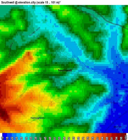
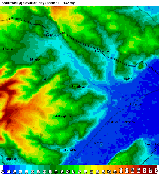
Below is the Elevation map of Southwell, which displays elevation range with different colors. Scale of the first map is from 15 to 101 m (49 to 331 ft) with average elevation of 45.2 meters (=148 ft) [note 1]
These maps also provides idea of topography and contour of this city, they are displayed at different zoom levels. More info about maps, scale and edge coordinates you can find below images.
| \ | Map #1 | Map #2 | Topo.Map |
| Scale [m] | 15..101 m | 11..132 m | × |
| Scale [ft] | 49..331 ft | 36..433 ft | × |
| Average | 45.2 m = 148 ft | 49.9 m = 164 ft | × |
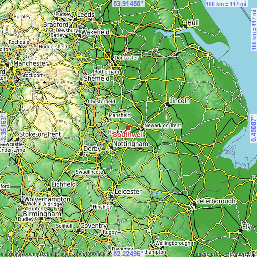
| Width | 5.87 km = 3.6 mi | 11.74 km = 7.3 mi | 187.9 km = 116.8 mi |
| Height | 5.87 km = 3.6 mi | 11.74 km = 7.3 mi | 187.8 km = 116.7 mi |
| ↑Max Latitude | 53.104431° | 53.130806° | 53.91455° |
| Latitude at center | 53.07804° | 53.07804° | 53.07804° |
| ↓Min Latitude | 53.051633° | 53.025209° | 52.22496° |
| ← Min Longitude | -0.999325° | -1.043271° | -2.36163° |
| Longitude center | -0.95538° | -0.95538° | -0.95538° |
| →Max Longitude | -0.911435° | -0.867489° | 0.45087° |
Nearby cities:
Cities around Southwell sort by population:
• Newark on Trent elevation 16 m
9.4 km,  97°
97°
• Boughton 39 m
13.7 km,  352°
352°
• Rainworth 99 m
11.8 km,  292°
292°
• Calverton 54 m
9.6 km,  241°
241°
• Ravenshead 137 m
13.7 km,  273°
273°
• Blidworth 111 m
11 km,  281°
281°
• Burton Joyce 22 m
11.3 km,  207°
207°
• Bilsthorpe 77 m
8.7 km,  322°
322°
• Farnsfield 58 m
5.9 km,  297°
297°
• Farndon 13 m
7.7 km,  113°
113°
• Lowdham 25 m
8 km,  204°
204°
• East Bridgford 52 m
11 km,  183°
183°
Multilingual:
 En español:
Southwell elevación 42 m.
 En France:
Southwell élévation 42 m.
 Auf Deutsch:
Southwell höhe über dem Meeresspiegel ist 42 m.

Sources and notes:
- [note 1] Map square and city borders are not equal. Map elevation data is calculated only from area inside that square.
- [src 1] Elevation data from geonames database provided with same terms of usage.
- [src 2] The elevation map of Southwell is generated using elevation data from NASA's 3 arcsec (90m) resolution SRTM data.
- [src 3] Base (background) map © OpenStreetMap contributors tiles are generated by Geofabrik and OpenTopoMap.
Copyright & License:
This Southwell Elevation Map is licensed under CC BY-SA. You may reuse any part from this page, if you give a proper credit by linking to this URL:
 More info on terms of use page.