Trelech elevation
Trelech (Wales, Carmarthenshire), United Kingdom elevation is 190 meters and Trelech elevation in feet is 623 ft above sea level [src 1]. Trelech is a seat of a third-order administrative division (feature code) with elevation that is 118 meters (387 ft) bigger than average city elevation in United Kingdom.
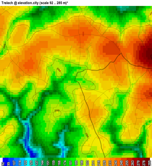
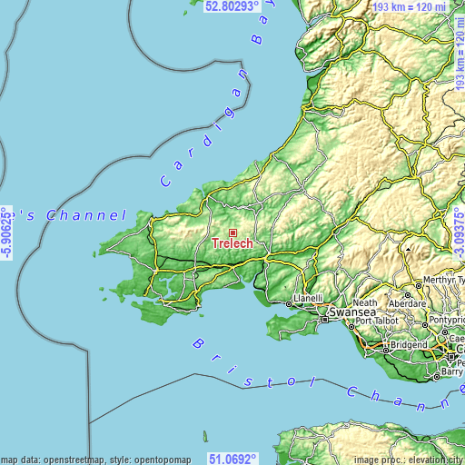
Below is the Elevation map of Trelech, which displays elevation range with different colors. Scale of the first map is from 92 to 285 m (302 to 935 ft) with average elevation of 201.9 meters (=662 ft) [note 1]
These maps also provides idea of topography and contour of this city, they are displayed at different zoom levels. More info about maps, scale and edge coordinates you can find below images.
| \ | Map #1 | Topo.Map |
| Scale [m] | 92..285 m | × |
| Scale [ft] | 302..935 ft | × |
| Average | 201.9 m = 662 ft | × |
| Width | 6.02 km = 3.7 mi | 192.8 km = 119.8 mi |
| Height | 6.02 km = 3.7 mi | 192.8 km = 119.8 mi |
| ↑Max Latitude | 51.971521° | 52.80293° |
| Latitude at center | 51.94444° | 51.94444° |
| ↓Min Latitude | 51.917343° | 51.0692° |
| ← Min Longitude | -4.543945° | -5.90625° |
| Longitude center | -4.5° | -4.5° |
| →Max Longitude | -4.456055° | -3.09375° |
Nearby cities:
Cities around Trelech sort by population:
• Carmarthen elevation 23 m
16.6 km,  126°
126°
• Newcastle Emlyn 31 m
10.9 km,  12°
12°
• Saint Clears 7 m
13.8 km,  179°
179°
• Glandwr 130 m
9.3 km,  258°
258°
• Whitland 20 m
16 km,  209°
209°
• Llandysul 80 m
17 km,  50°
50°
• Crymych 226 m
10.6 km,  287°
287°
• Llanddowror 9 m
16 km,  187°
187°
• Llangynog 114 m
15 km,  155°
155°
• Llanboidy 92 m
9.7 km,  221°
221°
• Abernant 84 m
9.1 km,  140°
140°
• Llanwinio 184 m
4.5 km, 207°
Multilingual:
 En español:
Trelech elevación 190 m.
 En France:
Trelech élévation 190 m.


Sources and notes:
- [note 1] Map square and city borders are not equal. Map elevation data is calculated only from area inside that square.
- [src 1] Elevation data from geonames database provided with same terms of usage.
- [src 2] The elevation map of Trelech is generated using elevation data from NASA's 3 arcsec (90m) resolution SRTM data.
- [src 3] Base (background) map © OpenStreetMap contributors tiles are generated by Geofabrik and OpenTopoMap.
Copyright & License:
This Trelech Elevation Map is licensed under CC BY-SA. You may reuse any part from this page, if you give a proper credit by linking to this URL:
 More info on terms of use page.