Weymouth elevation
Weymouth (England, Dorset), United Kingdom elevation is -2 meters and Weymouth elevation in feet is -7 ft above sea level [src 1]. Weymouth is a populated place (feature code) with elevation that is 74 meters (243 ft) smaller than average city elevation in United Kingdom.
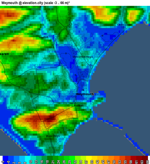
Below is the Elevation map of Weymouth, which displays elevation range with different colors. Scale of the first map is from -3 to 66 m (-10 to 217 ft) with average elevation of 17.5 meters (=57 ft) [note 1]
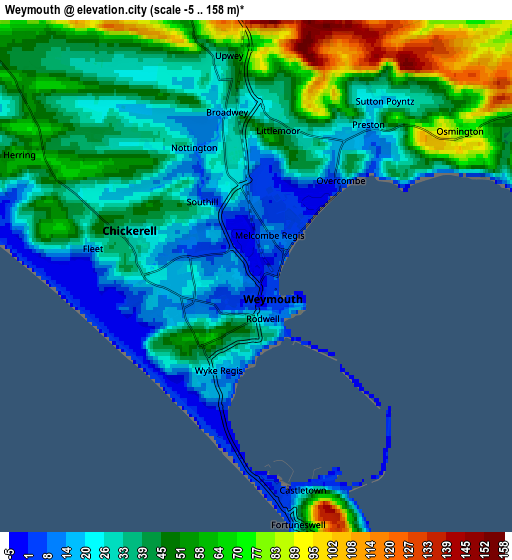
These maps also provides idea of topography and contour of this city, they are displayed at different zoom levels. More info about maps, scale and edge coordinates you can find below images.
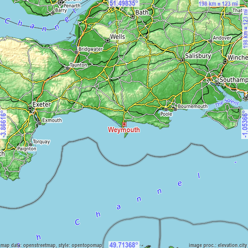
| \ | Map #1 | Map #2 | Topo.Map |
| Scale [m] | -3..66 m | -5..158 m | × |
| Scale [ft] | -10..217 ft | -16..518 ft | × |
| Average | 17.5 m = 57 ft | 41.6 m = 136 ft | × |
| Width | 6.2 km = 3.9 mi | 12.4 km = 7.7 mi | 198.4 km = 123.3 mi |
| Height | 6.2 km = 3.9 mi | 12.4 km = 7.7 mi | 198.4 km = 123.3 mi |
| ↑Max Latitude | 50.642357° | 50.670217° | 51.49835° |
| Latitude at center | 50.61448° | 50.61448° | 50.61448° |
| ↓Min Latitude | 50.586587° | 50.558677° | 49.71368° |
| ← Min Longitude | -2.503855° | -2.547801° | -3.86616° |
| Longitude center | -2.45991° | -2.45991° | -2.45991° |
| →Max Longitude | -2.415965° | -2.372019° | -1.05366° |
Nearby cities:
Cities around Weymouth sort by population:
• Dorchester elevation 55 m
11.5 km,  9°
9°
• Portland 11 m
5.3 km,  168°
168°
• Easton 61 m
9.1 km,  175°
175°
• Overcombe 7 m
3 km,  40°
40°
• Fortuneswell 56 m
6.1 km, 168°
• Chickerell 29 m
3.2 km,  289°
289°
• Wool 18 m
18.5 km,  66°
66°
• Bovington Camp 41 m
18.4 km,  59°
59°
• Charminster 83 m
13.2 km,  3°
3°
• Maiden Newton 98 m
19.9 km,  336°
336°
• Puddletown 59 m
16.9 km,  27°
27°
• Milborne St Andrew 75 m
22.1 km, 34°
Multilingual:
 En español:
Weymouth elevación -2 m.
 En France:
Weymouth élévation -2 m.


Sources and notes:
- [note 1] Map square and city borders are not equal. Map elevation data is calculated only from area inside that square.
- [src 1] Elevation data from geonames database provided with same terms of usage.
- [src 2] The elevation map of Weymouth is generated using elevation data from NASA's 3 arcsec (90m) resolution SRTM data.
- [src 3] Base (background) map © OpenStreetMap contributors tiles are generated by Geofabrik and OpenTopoMap.
Copyright & License:
This Weymouth Elevation Map is licensed under CC BY-SA. You may reuse any part from this page, if you give a proper credit by linking to this URL:
 More info on terms of use page.