Baille elevation
Baille (Provence-Alpes-Côte d'Azur, Département des Bouches-du-Rhône), France elevation is 31 meters and Baille elevation in feet is 102 ft above sea level [src 1]. Baille is a section of populated place (feature code) with elevation that is 143 meters (469 ft) smaller than average city elevation in France.
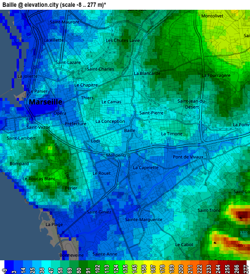
Below is the Elevation map of Baille, which displays elevation range with different colors. Scale of the first map is from -8 to 277 m (-26 to 909 ft) with average elevation of 53.4 meters (=175 ft) [note 1]
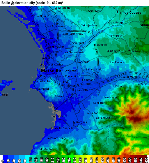
These maps also provides idea of topography and contour of this city, they are displayed at different zoom levels. More info about maps, scale and edge coordinates you can find below images.
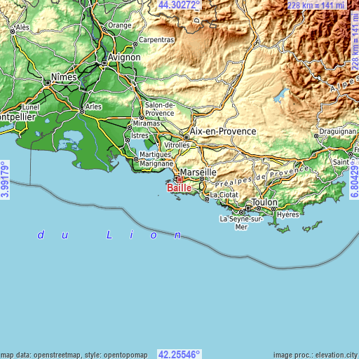
| \ | Map #1 | Map #2 | Topo.Map |
| Scale [m] | -8..277 m | -9..632 m | × |
| Scale [ft] | -26..909 ft | -30..2073 ft | × |
| Average | 53.4 m = 175 ft | 118.5 m = 389 ft | × |
| Width | 7.11 km = 4.4 mi | 14.23 km = 8.8 mi | 227.6 km = 141.4 mi |
| Height | 7.11 km = 4.4 mi | 14.23 km = 8.8 mi | 227.6 km = 141.4 mi |
| ↑Max Latitude | 43.31968° | 43.351644° | 44.30272° |
| Latitude at center | 43.2877° | 43.2877° | 43.2877° |
| ↓Min Latitude | 43.255703° | 43.223689° | 42.25546° |
| ← Min Longitude | 5.354095° | 5.310149° | 3.99179° |
| Longitude center | 5.39804° | 5.39804° | 5.39804° |
| →Max Longitude | 5.441985° | 5.485931° | 6.80429° |
Nearby cities:
Cities around Baille sort by population:
• Marseille 05 elevation 39 m
0.9 km,  13°
13°
• Le Camas 40 m
0.8 km,  337°
337°
• La Blancarde 80 m
1.5 km,  23°
23°
• Rouet 19 m
1.2 km,  206°
206°
• La Capelette 20 m
1 km,  139°
139°
• La Conception 40 m
0.6 km,  323°
323°
• Saint-Pierre 54 m
0.9 km,  51°
51°
• Lodi 31 m
0.8 km,  260°
260°
• Castellane 31 m
1.3 km, 260°
• Notre-Dame du Mont 40 m
1.4 km,  294°
294°
• La Timone 36 m
1.3 km,  86°
86°
• Menpenti 20 m
0.7 km,  194°
194°
Multilingual:
 En español:
Baille elevación 31 m.
 En France:
Baille élévation 31 m.


Sources and notes:
- [note 1] Map square and city borders are not equal. Map elevation data is calculated only from area inside that square.
- [src 1] Elevation data from geonames database provided with same terms of usage.
- [src 2] The elevation map of Baille is generated using elevation data from NASA's 3 arcsec (90m) resolution SRTM data.
- [src 3] Base (background) map © OpenStreetMap contributors tiles are generated by Geofabrik and OpenTopoMap.
Copyright & License:
This Baille Elevation Map is licensed under CC BY-SA. You may reuse any part from this page, if you give a proper credit by linking to this URL:
 More info on terms of use page.