Bourgoin-Jallieu elevation
Bourgoin-Jallieu (Auvergne-Rhône-Alpes, Département de l'Isère), France elevation is 248 meters and Bourgoin-Jallieu elevation in feet is 814 ft above sea level [src 1]. Bourgoin-Jallieu is a seat of a fourth-order administrative division (feature code) with elevation that is 74 meters (243 ft) bigger than average city elevation in France.
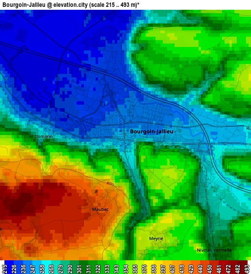
Below is the Elevation map of Bourgoin-Jallieu, which displays elevation range with different colors. Scale of the first map is from 215 to 493 m (705 to 1617 ft) with average elevation of 312.9 meters (=1027 ft) [note 1]
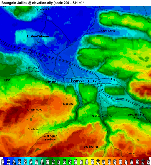
These maps also provides idea of topography and contour of this city, they are displayed at different zoom levels. More info about maps, scale and edge coordinates you can find below images.
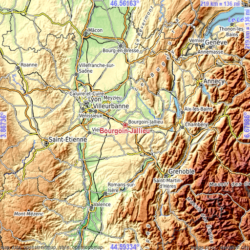
| \ | Map #1 | Map #2 | Topo.Map |
| Scale [m] | 215..493 m | 206..531 m | × |
| Scale [ft] | 705..1617 ft | 676..1742 ft | × |
| Average | 312.9 m = 1027 ft | 340.4 m = 1117 ft | × |
| Width | 6.84 km = 4.3 mi | 13.68 km = 8.5 mi | 218.9 km = 136 mi |
| Height | 6.84 km = 4.3 mi | 13.68 km = 8.5 mi | 218.8 km = 136 mi |
| ↑Max Latitude | 45.616856° | 45.647585° | 46.56163° |
| Latitude at center | 45.58611° | 45.58611° | 45.58611° |
| ↓Min Latitude | 45.555347° | 45.524567° | 44.59334° |
| ← Min Longitude | 5.229665° | 5.185719° | 3.86736° |
| Longitude center | 5.27361° | 5.27361° | 5.27361° |
| →Max Longitude | 5.317555° | 5.361501° | 6.67986° |
Nearby cities:
Cities around Bourgoin-Jallieu sort by population:
• L’Isle-d’Abeau elevation 232 m
5.3 km,  314°
314°
• Ruy 313 m
3.7 km,  89°
89°
• Saint-Chef 320 m
9 km,  52°
52°
• Saint-Savin 261 m
5.4 km,  30°
30°
• Vaulx-Milieu 219 m
7.6 km,  293°
293°
• Cessieu 310 m
8.4 km,  107°
107°
• Nivolas-Vermelle 311 m
3.9 km,  140°
140°
• Saint-Alban-de-Roche 228 m
3.8 km,  284°
284°
• Frontonas 309 m
8.8 km,  317°
317°
• Roche 350 m
8.7 km,  270°
270°
• Domarin 234 m
2.1 km, 271°
• Maubec 439 m
2.2 km,  200°
200°
Multilingual:
 En español:
Bourgoin-Jallieu elevación 248 m.
 En France:
Bourgoin-Jallieu élévation 248 m.
 Auf Deutsch:
Bourgoin-Jallieu höhe über dem Meeresspiegel ist 248 m.

Sources and notes:
- [note 1] Map square and city borders are not equal. Map elevation data is calculated only from area inside that square.
- [src 1] Elevation data from geonames database provided with same terms of usage.
- [src 2] The elevation map of Bourgoin-Jallieu is generated using elevation data from NASA's 3 arcsec (90m) resolution SRTM data.
- [src 3] Base (background) map © OpenStreetMap contributors tiles are generated by Geofabrik and OpenTopoMap.
Copyright & License:
This Bourgoin-Jallieu Elevation Map is licensed under CC BY-SA. You may reuse any part from this page, if you give a proper credit by linking to this URL:
 More info on terms of use page.