Ajaccio elevation
Ajaccio (Corsica, Département de la Corse-du-Sud), France elevation is 12 meters and Ajaccio elevation in feet is 39 ft above sea level [src 1]. Ajaccio is a seat of a first-order administrative division (feature code) with elevation that is 162 meters (531 ft) smaller than average city elevation in France.
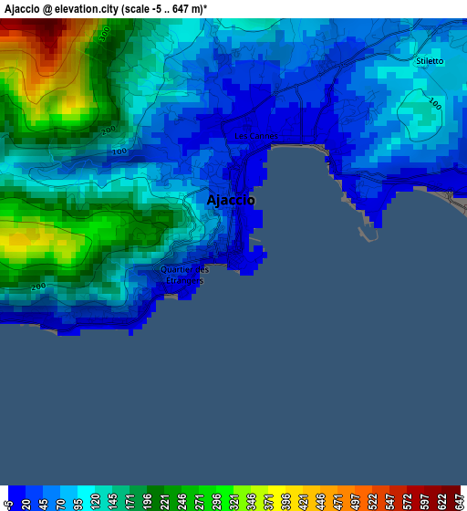
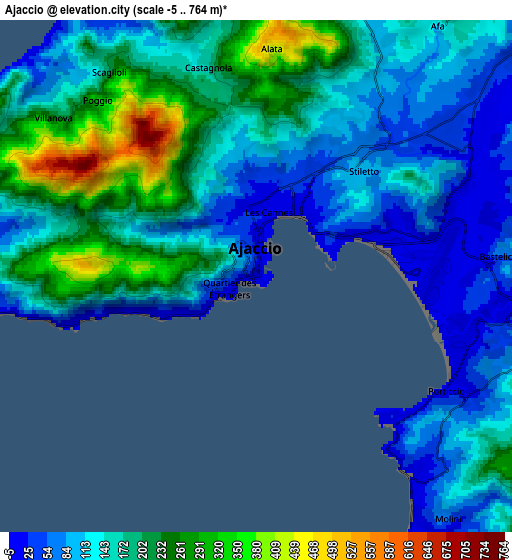
Below is the Elevation map of Ajaccio, which displays elevation range with different colors. Scale of the first map is from -5 to 647 m (-16 to 2123 ft) with average elevation of 126.2 meters (=414 ft) [note 1]
These maps also provides idea of topography and contour of this city, they are displayed at different zoom levels. More info about maps, scale and edge coordinates you can find below images.
| \ | Map #1 | Map #2 | Topo.Map |
| Scale [m] | -5..647 m | -5..764 m | × |
| Scale [ft] | -16..2123 ft | -16..2507 ft | × |
| Average | 126.2 m = 414 ft | 155.7 m = 511 ft | × |
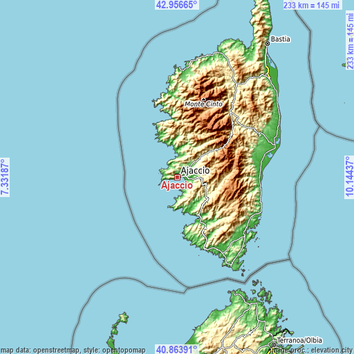
| Width | 7.27 km = 4.5 mi | 14.54 km = 9 mi | 232.7 km = 144.6 mi |
| Height | 7.27 km = 4.5 mi | 14.54 km = 9 mi | 232.7 km = 144.6 mi |
| ↑Max Latitude | 41.951551° | 41.984225° | 42.95665° |
| Latitude at center | 41.91886° | 41.91886° | 41.91886° |
| ↓Min Latitude | 41.886152° | 41.853428° | 40.86391° |
| ← Min Longitude | 8.694175° | 8.650229° | 7.33187° |
| Longitude center | 8.73812° | 8.73812° | 8.73812° |
| →Max Longitude | 8.782065° | 8.826011° | 10.14437° |
Nearby cities:
Cities around Ajaccio sort by population:
• Grosseto-Prugna elevation 442 m
19.4 km,  105°
105°
• Alata 442 m
6.4 km,  2°
2°
• Afa 199 m
8.8 km,  34°
34°
• Sarrola 393 m
14.9 km,  35°
35°
• Cuttoli-Corticchiato 760 m
16.4 km,  64°
64°
• Albitreccia 477 m
18 km, 110°
• Appietto 441 m
10.9 km,  13°
13°
• Peri 429 m
17.8 km, 58°
• Olmeto 360 m
26.9 km,  146°
146°
• Cauro 361 m
14.6 km,  90°
90°
• Pietrosella 484 m
12.8 km,  136°
136°
• Cargèse 88 m
26.9 km,  334°
334°
Multilingual:
 En español:
Ajaccio elevación 12 m.
 En France:
Ajaccio élévation 12 m.


Sources and notes:
- [note 1] Map square and city borders are not equal. Map elevation data is calculated only from area inside that square.
- [src 1] Elevation data from geonames database provided with same terms of usage.
- [src 2] The elevation map of Ajaccio is generated using elevation data from NASA's 3 arcsec (90m) resolution SRTM data.
- [src 3] Base (background) map © OpenStreetMap contributors tiles are generated by Geofabrik and OpenTopoMap.
Copyright & License:
This Ajaccio Elevation Map is licensed under CC BY-SA. You may reuse any part from this page, if you give a proper credit by linking to this URL:
 More info on terms of use page.