Ajain elevation
Ajain (Nouvelle-Aquitaine, Creuse), France elevation is 488 meters and Ajain elevation in feet is 1601 ft above sea level [src 1]. Ajain is a populated place (feature code) with elevation that is 314 meters (1030 ft) bigger than average city elevation in France.
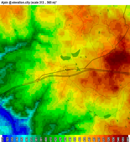
Below is the Elevation map of Ajain, which displays elevation range with different colors. Scale of the first map is from 313 to 565 m (1027 to 1854 ft) with average elevation of 456.4 meters (=1497 ft) [note 1]
These maps also provides idea of topography and contour of this city, they are displayed at different zoom levels. More info about maps, scale and edge coordinates you can find below images.
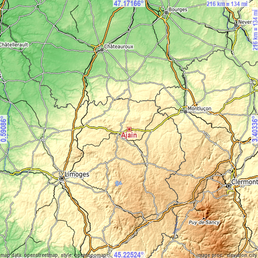
| \ | Map #1 | Topo.Map |
| Scale [m] | 313..565 m | × |
| Scale [ft] | 1027..1854 ft | × |
| Average | 456.4 m = 1497 ft | × |
| Width | 6.76 km = 4.2 mi | 216.4 km = 134.5 mi |
| Height | 6.76 km = 4.2 mi | 216.4 km = 134.5 mi |
| ↑Max Latitude | 46.237474° | 47.17166° |
| Latitude at center | 46.20707° | 46.20707° |
| ↓Min Latitude | 46.176649° | 45.22524° |
| ← Min Longitude | 1.953165° | 0.59086° |
| Longitude center | 1.99711° | 1.99711° |
| →Max Longitude | 2.041055° | 3.40336° |
Nearby cities:
Cities around Ajain sort by population:
• Guéret elevation 454 m
10.4 km,  247°
247°
• Sainte-Feyre 450 m
9.8 km,  219°
219°
• Saint-Vaury 457 m
18.6 km,  269°
269°
• Saint-Sulpice-le-Guérétois 379 m
13 km, 266°
• Aigurande 435 m
28.3 km,  333°
333°
• Ahun 453 m
14 km,  164°
164°
• Gouzon 371 m
18.7 km,  95°
95°
• Boussac 381 m
23.3 km,  47°
47°
• Le Grand-Bourg 390 m
27.6 km,  259°
259°
• Bonnat 346 m
15.2 km, 331°
• Dun-le-Palestel 370 m
27.8 km,  293°
293°
• Bussière-Dunoise 422 m
18.9 km, 287°
Multilingual:
 En español:
Ajain elevación 488 m.
 En France:
Ajain élévation 488 m.


Sources and notes:
- [note 1] Map square and city borders are not equal. Map elevation data is calculated only from area inside that square.
- [src 1] Elevation data from geonames database provided with same terms of usage.
- [src 2] The elevation map of Ajain is generated using elevation data from NASA's 3 arcsec (90m) resolution SRTM data.
- [src 3] Base (background) map © OpenStreetMap contributors tiles are generated by Geofabrik and OpenTopoMap.
Copyright & License:
This Ajain Elevation Map is licensed under CC BY-SA. You may reuse any part from this page, if you give a proper credit by linking to this URL:
 More info on terms of use page.