Alby-sur-Chéran elevation
Alby-sur-Chéran (Auvergne-Rhône-Alpes, Haute-Savoie), France elevation is 458 meters and Alby-sur-Chéran elevation in feet is 1503 ft above sea level [src 1]. Alby-sur-Chéran is a populated place (feature code) with elevation that is 284 meters (932 ft) bigger than average city elevation in France.
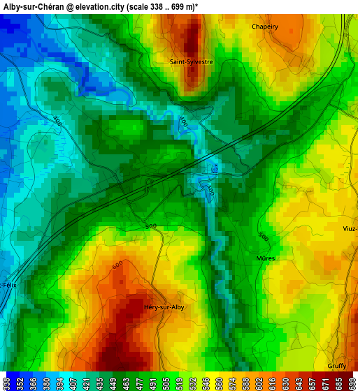
Below is the Elevation map of Alby-sur-Chéran, which displays elevation range with different colors. Scale of the first map is from 338 to 699 m (1109 to 2293 ft) with average elevation of 498.9 meters (=1637 ft) [note 1]
These maps also provides idea of topography and contour of this city, they are displayed at different zoom levels. More info about maps, scale and edge coordinates you can find below images.
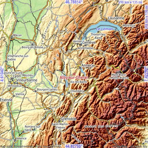
| \ | Map #1 | Topo.Map |
| Scale [m] | 338..699 m | × |
| Scale [ft] | 1109..2293 ft | × |
| Average | 498.9 m = 1637 ft | × |
| Width | 6.81 km = 4.2 mi | 218 km = 135.5 mi |
| Height | 6.81 km = 4.2 mi | 217.9 km = 135.4 mi |
| ↑Max Latitude | 45.84729° | 46.78814° |
| Latitude at center | 45.81667° | 45.81667° |
| ↓Min Latitude | 45.786034° | 44.82795° |
| ← Min Longitude | 5.972725° | 4.61042° |
| Longitude center | 6.01667° | 6.01667° |
| →Max Longitude | 6.060615° | 7.42292° |
Nearby cities:
Cities around Alby-sur-Chéran sort by population:
• Seynod elevation 542 m
9.5 km,  35°
35°
• Rumilly 347 m
7.4 km,  311°
311°
• Albens 350 m
6.4 km,  239°
239°
• Chavanod 510 m
8.3 km,  12°
12°
• La Biolle 405 m
9.4 km,  226°
226°
• Saint-Félix 493 m
3.4 km, 243°
• Sales 400 m
7.8 km,  325°
325°
• Marcellaz-Albanais 520 m
6.7 km,  348°
348°
• Cusy 623 m
5.7 km,  170°
170°
• Gruffy 700 m
4.4 km,  134°
134°
• Viuz-la-Chiésaz 700 m
3.9 km,  97°
97°
• Lovagny 530 m
9.8 km, 7°
Multilingual:
 En español:
Alby-sur-Chéran elevación 458 m.
 En France:
Alby-sur-Chéran élévation 458 m.
 Auf Deutsch:
Alby-sur-Chéran höhe über dem Meeresspiegel ist 458 m.

Sources and notes:
- [note 1] Map square and city borders are not equal. Map elevation data is calculated only from area inside that square.
- [src 1] Elevation data from geonames database provided with same terms of usage.
- [src 2] The elevation map of Alby-sur-Chéran is generated using elevation data from NASA's 3 arcsec (90m) resolution SRTM data.
- [src 3] Base (background) map © OpenStreetMap contributors tiles are generated by Geofabrik and OpenTopoMap.
Copyright & License:
This Alby-sur-Chéran Elevation Map is licensed under CC BY-SA. You may reuse any part from this page, if you give a proper credit by linking to this URL:
 More info on terms of use page.