Alès elevation
Alès (Occitanie, Gard), France elevation is 135 meters and Alès elevation in feet is 443 ft above sea level [src 1]. Alès is a seat of a third-order administrative division (feature code) with elevation that is 39 meters (128 ft) smaller than average city elevation in France.
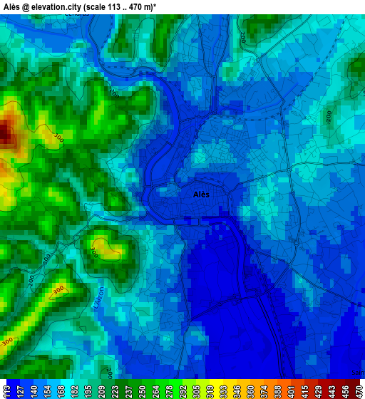
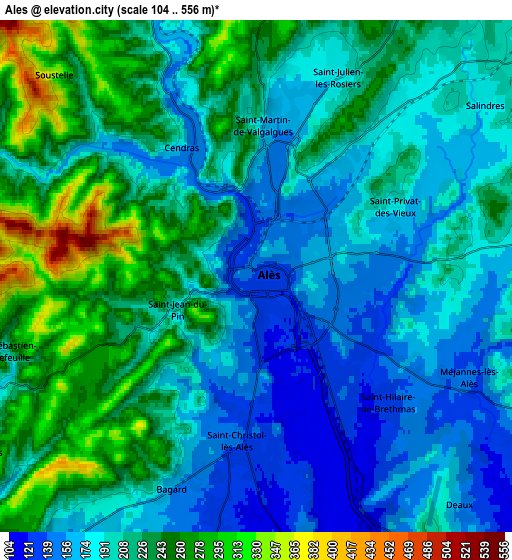
Below is the Elevation map of Alès, which displays elevation range with different colors. Scale of the first map is from 113 to 470 m (371 to 1542 ft) with average elevation of 176.5 meters (=579 ft) [note 1]
These maps also provides idea of topography and contour of this city, they are displayed at different zoom levels. More info about maps, scale and edge coordinates you can find below images.
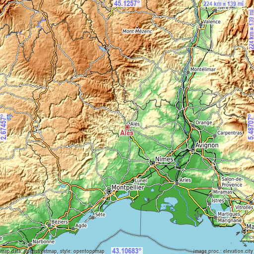
| \ | Map #1 | Map #2 | Topo.Map |
| Scale [m] | 113..470 m | 104..556 m | × |
| Scale [ft] | 371..1542 ft | 341..1824 ft | × |
| Average | 176.5 m = 579 ft | 206.8 m = 678 ft | × |
| Width | 7.01 km = 4.4 mi | 14.03 km = 8.7 mi | 224.5 km = 139.5 mi |
| Height | 7.01 km = 4.4 mi | 14.03 km = 8.7 mi | 224.5 km = 139.5 mi |
| ↑Max Latitude | 44.156427° | 44.187946° | 45.1257° |
| Latitude at center | 44.12489° | 44.12489° | 44.12489° |
| ↓Min Latitude | 44.093337° | 44.061766° | 43.10683° |
| ← Min Longitude | 4.036875° | 3.992929° | 2.67457° |
| Longitude center | 4.08082° | 4.08082° | 4.08082° |
| →Max Longitude | 4.124765° | 4.168711° | 5.48707° |
Nearby cities:
Cities around Alès sort by population:
• Saint-Christol-lès-Alès elevation 136 m
4.7 km,  185°
185°
• Saint-Martin-de-Valgalgues 180 m
4.3 km,  3°
3°
• Saint-Privat-des-Vieux 198 m
4.5 km,  61°
61°
• Saint-Hilaire-de-Brethmas 136 m
6.1 km,  144°
144°
• Salindres 184 m
8.2 km,  50°
50°
• Rousson 224 m
9.1 km,  35°
35°
• Saint-Julien-les-Rosiers 178 m
5.9 km,  21°
21°
• Bagard 152 m
6.4 km,  200°
200°
• Cendras 215 m
3 km,  337°
337°
• Vézénobres 153 m
9.4 km,  150°
150°
• Mons 212 m
7.5 km,  98°
98°
• Laval-Pradel 247 m
9.2 km,  352°
352°
Multilingual:
 En español:
Alès elevación 135 m.
 En France:
Alès élévation 135 m.


Sources and notes:
- [note 1] Map square and city borders are not equal. Map elevation data is calculated only from area inside that square.
- [src 1] Elevation data from geonames database provided with same terms of usage.
- [src 2] The elevation map of Alès is generated using elevation data from NASA's 3 arcsec (90m) resolution SRTM data.
- [src 3] Base (background) map © OpenStreetMap contributors tiles are generated by Geofabrik and OpenTopoMap.
Copyright & License:
This Alès Elevation Map is licensed under CC BY-SA. You may reuse any part from this page, if you give a proper credit by linking to this URL:
 More info on terms of use page.